- My Forums
- Tiger Rant
- LSU Recruiting
- SEC Rant
- Saints Talk
- Pelicans Talk
- More Sports Board
- Coaching Changes
- Fantasy Sports
- Golf Board
- Soccer Board
- O-T Lounge
- Tech Board
- Home/Garden Board
- Outdoor Board
- Health/Fitness Board
- Movie/TV Board
- Book Board
- Music Board
- Political Talk
- Money Talk
- Fark Board
- Gaming Board
- Travel Board
- Food/Drink Board
- Ticket Exchange
- TD Help Board
Customize My Forums- View All Forums
- Show Left Links
- Topic Sort Options
- Trending Topics
- Recent Topics
- Active Topics
Started By
Message
 0
0

Posted on 8/31/17 at 10:05 am to slackster
quote:
These tweets are just unnecessary hype. Taking a southwesterly turn 3000 miles from the US doesn't mean a damn thing about what it will do in a week.
Absolutely. Climo taking as a whole can be useful. Individual storm tracks from the past are worthless at predicting anything that might happen.
Posted on 8/31/17 at 10:09 am to rds dc
quote:
However, pretty much all models are in the short term with this system. Big key, how much lat does it gain in the next 24hrs before bending back SW.
The eventual path pretty much depends on that big Atlantic ridge, how strong it is and it's general orientation correct? Will the big trough at the later part of the run provide an opening for Irma to cut NE.
In the short term, what impact will that little upper low shown at around 45 W and 25 N have on the evolution of the high?

Could that affect the short term progression north before the SW bend?
Posted on 8/31/17 at 10:12 am to rds dc
quote:
Absolutely. Climo taking as a whole can be useful. Individual storm tracks from the past are worthless at predicting anything that might happen.
It's irresponsible fear mongering.
Posted on 8/31/17 at 10:45 am to GEAUXmedic
Damn that euro path could put it in the gulf after landfall in Cuba.
Posted on 8/31/17 at 10:46 am to GEAUXmedic
Something else there are 2 more low systems behind Irma expected to come off the African coast
Posted on 8/31/17 at 10:47 am to slackster

Amazing what low wind shear can mean for a storm. Eye clearly starting to peek out. Outflow is strong. Looks incredibly healthy. What's amazing too is that the waters aren't all that warm. Will probably put the breaks on Irma getting 4-5 intense for the short term.
Posted on 8/31/17 at 10:48 am to GEAUXmedic
quote:
If it did in fact go over the mountains it would get shredded,
Even then it would have the entire gulf to reorganize. We saw with Harvey it don't take much to go from TS to Cat 4
Posted on 8/31/17 at 10:52 am to Jim Rockford
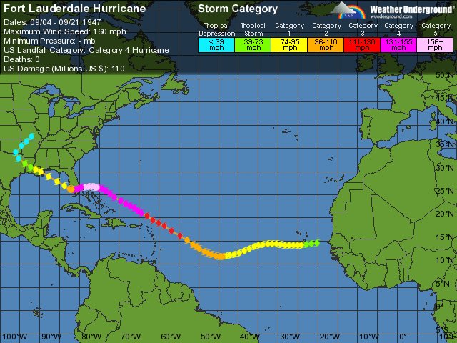
Nope nope nope
Posted on 8/31/17 at 10:52 am to deltaland
quote:
Even then it would have the entire gulf to reorganize. We saw with Harvey it don't take much to go from TS to Cat 4
The Cuba mountains tear up storms, but it's not the meat grinder Hispaniola tends to be. Of course, better it doesn't hit Hispaniola because a TS is a humanitarian crisis in Haiti.
Posted on 8/31/17 at 11:01 am to Duke
quote:
quote:
Even then it would have the entire gulf to reorganize. We saw with Harvey it don't take much to go from TS to Cat 4
The Cuba mountains tear up storms, but it's not the meat grinder Hispaniola tends to be. Of course, better it doesn't hit Hispaniola because a TS is a humanitarian crisis in Haiti.
Who cares. A TS hitting the gulf coast in the next 10 days would be devastating for all. Winds are important sure but if this thing makes it into the gulf then it is going to be much more eventful because of Harvey.
Posted on 8/31/17 at 11:04 am to UAinSOUTHAL
looks like the 12z GFS is currently running
Posted on 8/31/17 at 11:07 am to deltaland
Why the downvotes? I mean nope as in I do not want that potential path. ( I know it was a hurricane from the 40s) but they can gtfo with that shite
Posted on 8/31/17 at 11:13 am to deltaland
MF - a jump from 70 this morning to 100+ now.
Posted on 8/31/17 at 11:23 am to jdd48
looks like Irma starting to peek out in this model... next Thursday... still looks much further north than the Euro

Posted on 8/31/17 at 11:24 am to rt3
yeah... GFS definitely keeping the recurve in place... making it a Bermuda or fish storm
Posted on 8/31/17 at 11:26 am to deltaland


Posted on 8/31/17 at 11:26 am to rt3
quote:I'm liking the looks of it so far. No major development in GOM and Irma headed north. Only thing I don't like so far is that other system sneaking up behind Irma
looks like the 12z GFS is currently running
Posted on 8/31/17 at 11:28 am to ForeverLSU02
quote:
I'm liking the looks of it so far. No major development in GOM and Irma headed north. Only thing I don't like so far is that other system sneaking up behind Irma
yeah... system B sitting way further south than Irma
Posted on 8/31/17 at 11:29 am to deltaland
How are they able to map storm positions and intensities in the open ocean before satellites? Ship reports and island observations were sparse I'd imagine.

 Page 7 of 711

Popular
Back to top