- My Forums
- Tiger Rant
- LSU Recruiting
- SEC Rant
- Saints Talk
- Pelicans Talk
- More Sports Board
- Fantasy Sports
- Golf Board
- Soccer Board
- O-T Lounge
- Tech Board
- Home/Garden Board
- Outdoor Board
- Health/Fitness Board
- Movie/TV Board
- Book Board
- Music Board
- Political Talk
- Money Talk
- Fark Board
- Gaming Board
- Travel Board
- Food/Drink Board
- Ticket Exchange
- TD Help Board
Customize My Forums- View All Forums
- Show Left Links
- Topic Sort Options
- Trending Topics
- Recent Topics
- Active Topics
Started By
Message


 2
2

Posted on 9/7/17 at 10:27 am to LaBR4

Kind of reminds me of that box on hellraiser after its opened

Posted on 9/7/17 at 10:28 am to crispyUGA
quote:
Unglued from the TV? shite, I've been blued to this thread for at least the past 36 hours.
You need to try to shed some of your anxiety.
Posted on 9/7/17 at 10:29 am to soccerfüt
quote:
This model is called the "Making College Visits" path:
Irma's a bull dyke attracted to good southern girls
dem sundresses and boots
Posted on 9/7/17 at 10:30 am to TakingStock
quote:
Where do people get the GFS picture graphics that are typically posted? I follow the model runs on Levi's site, but a lot of times individual JPEG's are posted - just curious where I can find those.
Right click on the model frame you want, select properties, then select the image url. Paste it into the img link on here.
On Safari, right click and copy image address, then post. On mobile, click and hold the image, copy the link, then paste it here.
Lots of different ways.
Posted on 9/7/17 at 10:30 am to GEAUXmedic

General Lee down there bringing the Calvary from Cape Verde
Posted on 9/7/17 at 10:30 am to PsychTiger
quote:
Unglued from the TV? shite, I've been blued to this thread for at least the past 36 hours.
You need to try to shed some of your anxiety.
This thread has been better than any news coverage Ive seen at least.
Im pissed that they are not covering the VIs. Have family is there and have not had contact in 24 hours.
FB is the best source of information with a few boots on the ground and very very spotty Version service.
Trying to get info is hard. Screw the media on this one.
Posted on 9/7/17 at 10:30 am to 50_Tiger
quote:
Okay well damn no contraflow seems kinda mind boggling at this point.
I think the Governor gave them the OK for contraflow and they have decided not to do it yet. Bad decision.
What would Officer Blondie do?
Posted on 9/7/17 at 10:31 am to ForeverLSU02
quote:
Euro Ensembles for Jose
Border patrol turns Jose back around.
Posted on 9/7/17 at 10:32 am to DVinBR
quote:
Anyone else curious to how Irma is spitting out 180mph winds with only 920mb of pressure, most hurricanes with that kind of pressure are cat 4, you typically don't see 180 until around 900mb
The NHC said they might be a little high with their current maximum winds as Irma gets her act together again, and they recently dropped the winds to 175mph on the 10AM advisory.

Posted on 9/7/17 at 10:32 am to someLSUdoosh
It is expected to weaken quite a bit to a cat4 before it makes landfall in Miami though, right? Makes it much more manageable.
relatively speaking. There's a big difference between a 150mph beast and a 185mph monster.
relatively speaking. There's a big difference between a 150mph beast and a 185mph monster.

Posted on 9/7/17 at 10:33 am to TigerFanatic99
Fuuuu
Posted on 9/7/17 at 10:33 am to deltaland
quote:
Border patrol turns Jose back around.
about time they do their damn jobs
Posted on 9/7/17 at 10:33 am to Rhino5
quote:
Bumper-to-Bumper near Becker Rd. on the Turnpike
I see very few brake lights, so it looks like they're moving a decent clip.

Posted on 9/7/17 at 10:33 am to Hangit
quote:
What would Officer Blondie do?
The question is what wouldn't she do?
dammit I miss the LivePD crew.
I actually feel like all these hurricanes are there fault. As soon as they went off the air for a month all this shite started happening.
FUK U DAN
Posted on 9/7/17 at 10:35 am to jackmanusc
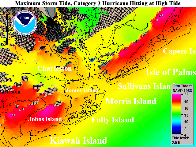
Holy frick that means Charleston under water?
Posted on 9/7/17 at 10:35 am to cajunangelle
quote:
GFDL: The NWS/Geophysical Fluid Dynamics Laboratory model. The GFDL and HWRF models are the only models that provide specific intensity forecasts of hurricanes. Wunderground.com makes these graphics available on Wundermap. More detailed GFDL graphics are available at NOAA/NCEP. See the "GHM" model under the heading, Hurricane Graphics.
The GFDL has been replaced by the HMON, fyi.
Posted on 9/7/17 at 10:35 am to rt3

Is this a fourth system coming in after Jose....date on the model is Sep 18th

Posted on 9/7/17 at 10:36 am to 50_Tiger
High tide is much different from low tide along the east coast, especially where that shows. So if it hits at low tide it will be several feet less than that.

Posted on 9/7/17 at 10:36 am to jackmanusc
This post was edited on 9/7/17 at 10:38 am

 Page 352 of 711

Popular
Back to top