- My Forums
- Tiger Rant
- LSU Recruiting
- SEC Rant
- Saints Talk
- Pelicans Talk
- More Sports Board
- Fantasy Sports
- Golf Board
- Soccer Board
- O-T Lounge
- Tech Board
- Home/Garden Board
- Outdoor Board
- Health/Fitness Board
- Movie/TV Board
- Book Board
- Music Board
- Political Talk
- Money Talk
- Fark Board
- Gaming Board
- Travel Board
- Food/Drink Board
- Ticket Exchange
- TD Help Board
Customize My Forums- View All Forums
- Show Left Links
- Topic Sort Options
- Trending Topics
- Recent Topics
- Active Topics
Started By
Message
re: Hurricane Florence - Catastrophic Flooding Potential
Posted on 9/10/18 at 11:39 am to cajunangelle

Posted on 9/10/18 at 11:39 am to cajunangelle
Another shitty fact of this is the lunar cylce...
So believe it or not, there are 20+ things (depending on your source) that affect tidal cycles.
The new moon was yesterday. The largest high tide in any given lunar cyle is during a new moon as that means the gravitational pull of the moon and sun are combined. That means this thing is going to hit with a spring (king) tide +4 days. While that's not as bad as it impacting during the new moon, that's a lot worse than it impacting a week or 2 from now.
Since the outer banks are wave dominated barrier islands, they'll see and increase of 2-3 feet over the normal storm surge.
However, the areas to the south (lowcountry of SC and GA) will see a much larger storm surge than would be expected because they're tidal/mezo-tidal dominated barrier islands.
Anywhere from St Simon, GA to Bull Island, SC can expect a 6-7 foot surge. Georgetown, SC through Norfolk, VA, you're looking at surges above 10 feet.
 2
2

Posted on 9/10/18 at 11:40 am to deltaland
quote:
If true this one may be headed to Cat 5 status before it’s all set and done
Theres a good possibility/probability it will be a cat5 by tomorrow, if not earlier. The only thing that will impede it is an EWRC, but if/when that happens this will grow into a giant storm.
Posted on 9/10/18 at 11:40 am to slackster
Why's the GFS skipping hours? Looks fubar.
Posted on 9/10/18 at 11:42 am to TheGasMan
quote:
TheGasMan
I'm looking forward to reading your thoughts as this thing gets closer.
Posted on 9/10/18 at 11:43 am to NYNolaguy1
quote:
Theres a good possibility/probability it will be a cat5 by tomorrow, if not earlier. The only thing that will impede it is an EWRC, but if/when that happens this will grow into a giant storm.
for the lay people... EWRC = Eye Wall Replacement Cycle
Posted on 9/10/18 at 11:43 am to deuce985
quote:
Why's the GFS skipping hours? Looks fubar.
It's just Levi's site. He's going to be overwhelmed with traffic the next week or so.
Posted on 9/10/18 at 11:43 am to rt3
I wonder if the Cajun Navy will mobilize to go that far? Our fellow Americans in the Carolinas will need the help. Widespread flooding in many very rural areas plus a lot of urban areas.
Potential is there to rival Katrina or worse if many people try to ride it out. I cannot stress enough to the people reading this if you live in the path, leave. Don’t be stupid
Potential is there to rival Katrina or worse if many people try to ride it out. I cannot stress enough to the people reading this if you live in the path, leave. Don’t be stupid

Posted on 9/10/18 at 11:44 am to jefffan
quote:I am not familiar with GA. but Statesboro or Augusta looks best. Does Augusta have pet friendly hotels? A got danged 5 hour drive no matter how you look at this...Hell it is 5 hours from coastal NC to Charlotte...
If you a direct line on I 77 and go east (basically from columbia Sc to NC/vs border) everything east of there is going to flood. Depending on south North track of storm.
I'm going to Augusta. Prob Thursday

Posted on 9/10/18 at 11:45 am to deltaland
The yellow circle represents 55+ MPH sustained winds at 10 meters.


Posted on 9/10/18 at 11:48 am to deltaland
quote:
Potential is there to rival Katrina or worse if many people try to ride it out. I cannot stress enough to the people reading this if you live in the path, leave. Don’t be stupid
Is the potential for flooding the same though?
Posted on 9/10/18 at 11:48 am to Bruco
quote:
Charlotte pucker factor at 6 but accelerating quickly.
It Charlotte as well. Biggest worry for me at the moment are the trees around the house.
Posted on 9/10/18 at 11:49 am to slackster
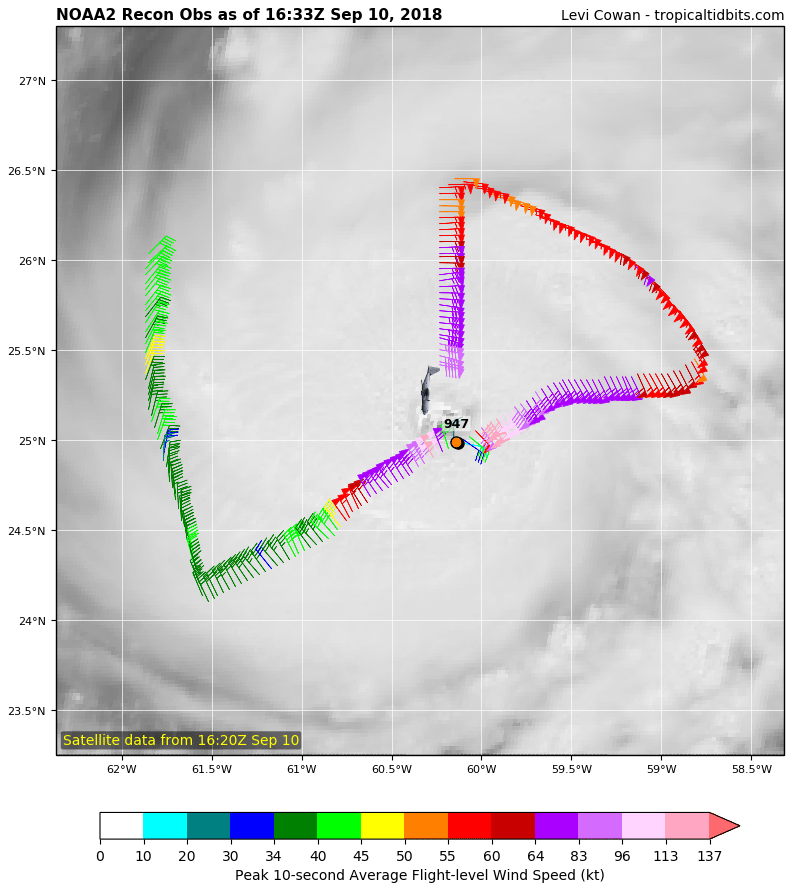
Looks like a hurricane wind field of abt 100 miles wide atm. Also pressure down to 942mb.
This post was edited on 9/10/18 at 11:49 am

Posted on 9/10/18 at 11:50 am to Duke
quote:
It has been the northern outlier this entire time, the NHC has mentioned it has a bit too strong of a northern bias.
This is the one situation where I wouldn't mind a little northern bias.
Posted on 9/10/18 at 11:50 am to slackster
12z GFS Thursday @ 7PM

Friday @ 7PM

Saturday @ 7PM

Sunday @ 7PM
And finally moving into mainland NC Monday @ 1AM:

RIP Outer Banks. Seriously, some islands will be underwater for 3.5 days with storm surge.
Friday @ 7PM
Saturday @ 7PM
Sunday @ 7PM
And finally moving into mainland NC Monday @ 1AM:
RIP Outer Banks. Seriously, some islands will be underwater for 3.5 days with storm surge.
Posted on 9/10/18 at 11:50 am to rt3
My mom just texted me asking if this will be worse than Sandy 
Umm yea this might be the worst in recorded history
Umm yea this might be the worst in recorded history
Posted on 9/10/18 at 11:51 am to deltaland
quote:
I wonder if the Cajun Navy will mobilize to go that far? Our fellow Americans in the Carolinas will need the help. Widespread flooding in many very rural areas plus a lot of urban areas.
They are now called...America's Cajun Navy
Suck it Kibbles

Posted on 9/10/18 at 11:51 am to slackster
Holy frick
I think this may actually fit the billing of the name DOOMCANE
I think this may actually fit the billing of the name DOOMCANE
Posted on 9/10/18 at 11:52 am to tgrbaitn08
From their Facebook Page
quote:
America's Cajun Navy
13 hrs ·
PLEASE SHARE... We’ve been contacted again by a different company this time. $40hr between 18-20 hrs a day. Standby time included and $30 a day for food. Fuel and lodging will be paid for. MUST HAVE 3/4 ton or bigger TRUCK with fuel cell in back and 4wd. Also first payment 2 weeks is 75% and then weekly the rest. So you will be paid in full for all hours documented by company. If interested message the page and we will get your info to them. This is in the Carolina’s. Again we are a volunteer group that is only helping them find Trucks cause we will be out there doing our normal rescues after the storm. Neighbors helping Neighbors is what we are about. Thanks and God Bless
We would like to have some trucks closer to North and South Carolina also
We will get back to everyone first thing in the morning. Thanks
Posted on 9/10/18 at 11:52 am to 50_Tiger
quote:
Pretty sure none of the models predicted this besides HMON
HMON finally got their doomcane wish
Posted on 9/10/18 at 11:52 am to NYNolaguy1
3 mb drop since last pass. Healthy strengthening and keeps looking better on satellite. Going to make a run at 5 it looks like.

 Page 143 of 400

Popular
Back to top