- My Forums
- Tiger Rant
- LSU Recruiting
- SEC Rant
- Saints Talk
- Pelicans Talk
- More Sports Board
- Fantasy Sports
- Golf Board
- Soccer Board
- O-T Lounge
- Tech Board
- Home/Garden Board
- Outdoor Board
- Health/Fitness Board
- Movie/TV Board
- Book Board
- Music Board
- Political Talk
- Money Talk
- Fark Board
- Gaming Board
- Travel Board
- Food/Drink Board
- Ticket Exchange
- TD Help Board
Customize My Forums- View All Forums
- Show Left Links
- Topic Sort Options
- Trending Topics
- Recent Topics
- Active Topics
Started By
Message
re: Hurricane Florence - Catastrophic Flooding Potential
Posted on 9/10/18 at 11:15 am to Pettifogger
Posted on 9/10/18 at 11:15 am to Pettifogger
12z GFS...

This post was edited on 9/10/18 at 11:16 am
 1
1

Posted on 9/10/18 at 11:15 am to LSUJuice
quote:
quote:
--------------------------------------------------------------------------------
are there any fears of mud slides and flash floods further inland?
--------------------------------------------------------------------------------
There should be. 40" in the mountains and foothills will be awful.
Hurricane Floyd is the nearest comparison to what Florence may bring. See images below.


Posted on 9/10/18 at 11:16 am to rt3
quote:
right now Isaac is forecast to run into some sheer in the Caribbean and get shredded to death there
Good news

Posted on 9/10/18 at 11:16 am to 50_Tiger
Outer banks are going to get slammed. We were planning a vacation there for next year. Hopefully it's still there.
Posted on 9/10/18 at 11:16 am to rds dc
The water temps in the gulf are boiling hot right now too
Posted on 9/10/18 at 11:18 am to TigerFanatic99
GFS has Florence stalled off the coast from 102 to 144 hours, at least, so far.
This post was edited on 9/10/18 at 11:19 am
Posted on 9/10/18 at 11:18 am to slackster
quote:
Supposedly the upper atmosphere readings from the earlier recon flight were going to be mixed into the 12z models. I guess we'll see if the Euro changes too.
I'm going to need to see the others cave first. NHC has been skeptical of the GFS so far north thus far. It likes to underdo the ridging. Wouldn't complain if it "wins" though.

Posted on 9/10/18 at 11:18 am to rds dc
That is one healthy arse wave moving into the gulf.
Posted on 9/10/18 at 11:18 am to deuce985
quote:
The water temps in the gulf are boiling hot right now too
what's the wind situation? enough sheering to keep the storm from jumping right up it seems
Posted on 9/10/18 at 11:19 am to Duke
quote:
I'm going to need to see the others cave first. NHC has been skeptical of the GFS so far north thus far. It likes to underdo the ridging. Wouldn't complain if it "wins" though.
didn't an earlier advisory/discussion by the NHC basically call the GFS an outlier?
Posted on 9/10/18 at 11:19 am to The Boat
That's what I was saying earlier that even if it doesn't develop into anything significant the way the models had it on land looked like it was going to dump a good bit of water on someone to where it might even be a flood event.
Posted on 9/10/18 at 11:20 am to rt3
quote:
didn't an earlier advisory/discussion by the NHC basically call the GFS an outlier?
It has been the northern outlier this entire time, the NHC has mentioned it has a bit too strong of a northern bias.
Posted on 9/10/18 at 11:20 am to The Boat
quote:
That is one healthy arse wave moving into the gulf.
Lot of convection, but very little in the way of lower level circulation.
Posted on 9/10/18 at 11:21 am to NYNolaguy1
quote:
12z GFS
When I pull up the 12z GFS it's not showing hours 72-102, which are some pretty important ones.
Posted on 9/10/18 at 11:21 am to deuce985
It’s been a while since Louisiana hasn’t been on the western side of a lopsided storm. If that thing slumps its way into Houston the area around Lake Charles might get dumped on.
This post was edited on 9/10/18 at 11:22 am
Posted on 9/10/18 at 11:25 am to rt3
GFS also has Isaac taking a northern turn now
Posted on 9/10/18 at 11:25 am to baseballmind1212

158 mph winds found ~1800 feet above the surface. Those tend to cycle down over time.
Posted on 9/10/18 at 11:27 am to deuce985
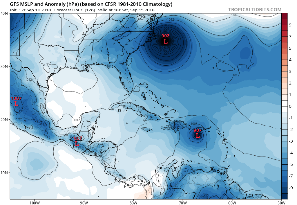
Am I seeing a 903mb on that projection?!
What does that even correlate to as far as estimated wind speed?
What does that even correlate to as far as estimated wind speed?
This post was edited on 9/10/18 at 11:29 am
Posted on 9/10/18 at 11:27 am to slackster
Even if they don’t Jeff will still yell about them like that’s what he’s experiencing.

Posted on 9/10/18 at 11:28 am to cajunangelle
quote:unholy hell.
Hurricane Florence is rapidly intensifying on its path toward the East Coast and is now a Category 4 with 130 mph winds, the National Hurricane Center said in a special update. Florence is expected to strengthen to 150 mph just prior to landfall somewhere on the Southeast or Mid-Atlantic Coast on Thursday night.
Computer model forecasts generally project the storm to make landfall between northern South Carolina and the North Carolina Outer Banks, although shifts in the track are still possible and storm impacts will expand great distances beyond where landfall occurs. Given the uncertainty and the time it takes to evacuate, officials in North Carolina have issued mandatory evacuation orders for Dare County and Hatteras Island.
With each passing flight into the eye of the storm and every new computer model forecast, it has become increasingly unlikely Florence will turn out to sea and spare the Eastern Seaboard from potentially devastating storm surge, flooding and wind. There’s even some indication the hurricane will slow or stall out over the Mid-Atlantic later this week, which could lead to a disastrous amount of rain.
Like Hurricane Harvey stalled over Texas in 2017, Florence could linger over the Southeast for several days after landfall. Forecast models suggest more than two feet of rain could fall over the higher elevations of the Carolinas and Virginia, which would generate dangerous flooding downstream. The flooding might be similar to what the Carolinas experienced during Hurricane Matthew in 2016.
As of 11 a.m., Monday, Florence was tracking west at 13 mph. Its peak winds were 130 mph, making it a Category 4 hurricane. It is not out of the question that Florence could become a Category 5 hurricane at some point. The official Hurricane Center forecast suggests its peak winds will reach 150 mph winds between Tuesday and Wednesday, just 7 mph below Category 5.
If Florence makes landfall as a Category 4 in North Carolina, it will be the strongest storm to come ashore that far north on record.

 Page 141 of 400

Popular
Back to top