- My Forums
- Tiger Rant
- LSU Recruiting
- SEC Rant
- Saints Talk
- Pelicans Talk
- More Sports Board
- Fantasy Sports
- Golf Board
- Soccer Board
- O-T Lounge
- Tech Board
- Home/Garden Board
- Outdoor Board
- Health/Fitness Board
- Movie/TV Board
- Book Board
- Music Board
- Political Talk
- Money Talk
- Fark Board
- Gaming Board
- Travel Board
- Food/Drink Board
- Ticket Exchange
- TD Help Board
Customize My Forums- View All Forums
- Show Left Links
- Topic Sort Options
- Trending Topics
- Recent Topics
- Active Topics
Started By
Message
re: Hurricane Florence - Catastrophic Flooding Potential
Posted on 9/10/18 at 11:01 am to Bruco
Posted on 9/10/18 at 11:01 am to Bruco
Officially a Category 4
LINK
LINK
quote:
Hurricane Florence Tropical Cyclone Update NWS National Hurricane Center Miami FL AL062018 1200 PM AST Mon Sep 10 2018 ...FLORENCE BECOMES A CATEGORY FOUR HURRICANE... Data from a NOAA Hurricane Hunter aircraft indicate that Florence has continued to rapidly stregthen and has maximum sustained winds near 130 mph (195 km/h). The latest minimum central pressure based on data from the aircraft is 946 mb (27.93 inches).
SUMMARY OF 1200 PM AST...1600 UTC...
INFORMATION ---------------------------------------------------
LOCATION...25.0N 60.2W ABOUT 575 MI...925 KM SSE OF BERMUDA ABOUT 1230 MI...1985 KM ESE OF CAPE FEAR NORTH CAROLINA MAXIMUM SUSTAINED WINDS...130 MPH...195 KM/H PRESENT MOVEMENT...W OR 280 DEGREES AT 13 MPH...20 KM/H MINIMUM CENTRAL PRESSURE...946 MB...27.93 INCHES
$$ Forecaster Blake
 1
1

Posted on 9/10/18 at 11:01 am to Pettifogger
that's beautiful/terrifying
Posted on 9/10/18 at 11:02 am to Duke
If people weren't paying attention before they will now. Cat 4's seem to grab attention pretty easily.
Posted on 9/10/18 at 11:03 am to Bruco
The Official Hurricane Anal Pucker Factor... sponsored by Boudreaux's Butt Paste

All of the Carolinas should be inside of "last quarter"
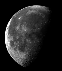
with the areas around the NC/SC line sporting a waxing/waning crescent

All of the Carolinas should be inside of "last quarter"
with the areas around the NC/SC line sporting a waxing/waning crescent

Posted on 9/10/18 at 11:03 am to tgrbaitn08
quote:
are there any fears of mud slides and flash floods further inland?
There should be. 40" in the mountains and foothills will be awful.
Posted on 9/10/18 at 11:04 am to Bruco
Whats the word with Houston?.. Had a dramatic person text me today telling me Houston is getting a hurricane on Friday..
Posted on 9/10/18 at 11:06 am to NYNolaguy1
quote:
If people weren't paying attention before they will now. Cat 4's seem to grab attention pretty easily.
Yeah, this will get everyone's attention. As bad as the coastal impacts will likely be, I hope everyone is just as mindful of the rain to come.
Now that we're in the major hurricane territory, the eyewall replacement cycle watch is about to begin. Not any time very soon as she fully ramps up of course, but will be a big piece to keep an eye on during the approach.
Posted on 9/10/18 at 11:06 am to BearCrocs
They have a system out by Yucatan that has a 40% chance to develop. Models were showing it drifting northwest towards Texas but none showed any significant development. Could be a depression by the time it hits land. Too early to say but it could cause a good bit of rain. Definitely being dramatic. Nothing suggests it developing into a hurricane yet.
Posted on 9/10/18 at 11:06 am to BearCrocs
quote:
Whats the word with Houston?.. Had a dramatic person text me today telling me Houston is getting a hurricane on Friday..
dramatic person is dramatic
there's a wave headed into the gulf... but the NHC gives it only small to medium chance of development over the next 5 days

Posted on 9/10/18 at 11:06 am to BearCrocs
quote:
Whats the word with Houston?.. Had a dramatic person text me today telling me Houston is getting a hurricane on Friday..
Tell them to read space city weather for updates
LINK
quote:
Next weekend and the tropics But wait, there’s more. The National Weather Service has started to track a blob of low pressure that should move from the Caribbean Sea, across the Yucatan Peninsula, into the Gulf of Mexico later Tuesday or Wednesday morning. Until that time it should face a pretty hostile environment for strengthening. But once in the Gulf it could find more favorable conditions. The National Hurricane Center gives this system about a 40 percent chance of becoming a tropical depression or storm during the next five days, and I feel that’s about right. Where’s it going? Whatever this system becomes, it likely is coming to Texas. At least that the conclusion of the European model, which shows solutions this morning for most of the state’s coastline. Please bear in mind that without any kind of low-pressure center—which seems unlikely to develop before this mess moves into the Gulf—it is hard to have much confidence in what will happen with this system.
quote:
As the tropical low moves into the Gulf of Mexico this week it has a chance to develop, most likely into a depression or tropical storm. But as this is early September, we can’t rule anything out. The system will bring increased tropical moisture into Texas, and this will result in increased rain chances, probably beginning Friday. Right now we aren’t seeing a signal for anything too extreme, nor can we say whether heavy rain is most likely for South Texas, the Coastal Bend, or the Houston-Galveston region. You should not be overly worried, but between the rains to start the week, and the potential for more heavy rainfall later this week, we definitely need to be weather aware for awhile. To that end, Matt and I will stay on top of things.

Posted on 9/10/18 at 11:07 am to BearCrocs
quote:
Whats the word with Houston?.. Had a dramatic person text me today telling me Houston is getting a hurricane on Friday..
You need new friends/relatives.
Posted on 9/10/18 at 11:07 am to BearCrocs
There is a disturbance in the gulf off the yucatan.
From what I can gather looks like it's just bringing heavy rain rn. Projecting it anywhere between houston and brownsville.
Eta: I'm more interested in Isaac. Looks like its shooting right for that traditional funnel through Haiti/DR.
From what I can gather looks like it's just bringing heavy rain rn. Projecting it anywhere between houston and brownsville.
Eta: I'm more interested in Isaac. Looks like its shooting right for that traditional funnel through Haiti/DR.
This post was edited on 9/10/18 at 11:11 am

Posted on 9/10/18 at 11:10 am to Duke
Will the recon plane make another pass through?
Posted on 9/10/18 at 11:12 am to Pettifogger
quote:
Will the recon plane make another pass through?
the planes typically fly a pattern that kinda resembles a nuclear hazard warning symbol... of course while moving with the storm

Posted on 9/10/18 at 11:12 am to rds dc
12z GFS looks like a best case scenario with system just missing the Outer Banks and now drifting away. Start of a trend?

Posted on 9/10/18 at 11:13 am to deuce985
quote:
They have a system out by Yucatan that has a 40% chance to develop. Models were showing it drifting northwest towards Texas but none showed any significant development. Could be a depression by the time it hits land. Too early to say but it could cause a good bit of rain. Definitely being dramatic. Nothing suggests it developing into a hurricane yet.
Blue Shed went through enough last year -- he needs a break
Posted on 9/10/18 at 11:13 am to Pettifogger
quote:
Will the recon plane make another pass through?
They'll probably make 3 passes through eye, at least.
Posted on 9/10/18 at 11:14 am to rds dc
quote:
12z GFS looks like a best case scenario with system just missing the Outer Banks and now drifting away. Start of a trend?
Supposedly the upper atmosphere readings from the earlier recon flight were going to be mixed into the 12z models. I guess we'll see if the Euro changes too.
ETA - Drifting away may actually be drifting SW...
This post was edited on 9/10/18 at 11:16 am
Posted on 9/10/18 at 11:15 am to baseballmind1212
quote:
Eta: I'm more interested in Isaac. Looks like its shooting right for that traditional funnel through Haiti/DR.
right now Isaac is forecast to run into some sheer in the Caribbean and get shredded to death there
Posted on 9/10/18 at 11:15 am to rds dc
WCAB disturbance moving towards the Gulf


 Page 140 of 400

Popular
Back to top