- My Forums
- Tiger Rant
- LSU Recruiting
- SEC Rant
- Saints Talk
- Pelicans Talk
- More Sports Board
- Coaching Changes
- Fantasy Sports
- Golf Board
- Soccer Board
- O-T Lounge
- Tech Board
- Home/Garden Board
- Outdoor Board
- Health/Fitness Board
- Movie/TV Board
- Book Board
- Music Board
- Political Talk
- Money Talk
- Fark Board
- Gaming Board
- Travel Board
- Food/Drink Board
- Ticket Exchange
- TD Help Board
Customize My Forums- View All Forums
- Show Left Links
- Topic Sort Options
- Trending Topics
- Recent Topics
- Active Topics
Started By
Message
re: Hurricane Dorian - Headed to Canada
Posted on 9/5/19 at 1:03 pm to TideWarrior
Posted on 9/5/19 at 1:03 pm to TideWarrior
quote:
On the Emerald Isle live feed waves are starting to hit near the top of the pier. Really has picked up in the last few minutes there.
The pier is brand new too, fully replaced just last summer from the previous hurricane. Hoping it makes it through this time in one piece
 0
0

Posted on 9/5/19 at 1:03 pm to NorthEndZone
Stay dry friend 

Posted on 9/5/19 at 1:08 pm to JETigER
quote:
So no “major” status when the Dorian strikes the US.
So no “stalled” Dorian over the US.
This was a nothing burger got the US.
The two ways a hurricane does damage is to be a major or stalled.
Lay off the crack pipe. NC Coast is just starting to see the beginning of their turn over the next 12 hours. Last year it got pounded by CAT 1 storms.
Posted on 9/5/19 at 1:15 pm to Arch Madness
Oyster Landing, SC just exceed Irma's water level at 3.37 feet (3.22 above normal tide) and there is another 30 minutes before high tide.
ETA: Final high water level was 3.47 feet, higher than Irma by 0.12 feet and only about 15 inches lower than Michael.
This gauge has only been installed since 2001.
ETA: Final high water level was 3.47 feet, higher than Irma by 0.12 feet and only about 15 inches lower than Michael.
This gauge has only been installed since 2001.
This post was edited on 9/5/19 at 3:06 pm
Posted on 9/5/19 at 1:23 pm to JETigER
quote:
The two ways a hurricane does damage is to be a major or stalled.
Category 2 Hurricane Ike:

Size matters more than simply Category for surge.

Posted on 9/5/19 at 1:31 pm to metallica81788
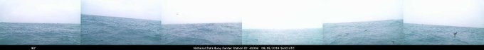
quote:
NWS Charleston, SC
@NWSCharlestonSC
This is a really interesting image from the Edisto buoy (41004) located ~40 miles SE of Charleston. The buoy is squarely in the eye of #Dorian and if you look closely at the web cam you can see birds flying around, likely trapped in the eye. LINK #scwx
NWS Charleston twitter

Posted on 9/5/19 at 1:33 pm to Duke
quote:
you don't have radarscope, pull up the NWS radar from Wilmington or Charleston. Just go to weather.gov, type in the location of interest and search. There will be a radar on the page.
Posted on 9/5/19 at 1:41 pm to Duke
Track matters too. If this hits perpendicular, it only affects a few communities with surge, and then takes out the power for a few dozen miles inland. Paralleling the coast hits hundreds of miles of shoreline with surge + wave erosion + ts force winds.
Posted on 9/5/19 at 1:41 pm to LSUJuice
quote:
Track matters too.
Certainly.

Posted on 9/5/19 at 1:56 pm to Duke
Size, location and angle to the coast matter a lot. You get bigger surges in the shallow gulf.
Posted on 9/5/19 at 2:58 pm to LSUJuice
quote:
Track matters too. If this hits perpendicular, it only affects a few communities with surge, and then takes out the power for a few dozen miles inland. Paralleling the coast hits hundreds of miles of shoreline with surge + wave erosion + ts force winds.
Not always because Florence came in perpendicular as a CAT 1 last year when it hit NC and the flooding was devastating to the area and some counties still recovering and rebuilding from that one. Just saying
Posted on 9/5/19 at 3:05 pm to TideWarrior
Yeah surge is much worse when a storm slams into the coast perpendicular compared to just paralleling it. Florence was also a cat 4 and cat 3 as it approached the coast so it built up a ton of water already even if it hit as a cat 1. Similar to what Katrina did. A storm hitting the coast and making landfall will always be worse than a storm that stays offshore and skims it like this.

Posted on 9/5/19 at 3:07 pm to JETigER
quote:
So no “major” status when the Dorian strikes the US.
So no “stalled” Dorian over the US.
This was a nothing burger got the US.
The two ways a hurricane does damage is to be a major or stalled.


Posted on 9/5/19 at 3:26 pm to rds dc
quote:
94L is on the board
Staying south

Posted on 9/5/19 at 3:40 pm to The Boat
Some Met Doctorate student should do his Thesis on Dorians Core.
I don’t think I’ve seen anything like it in terms of stability and general robustness:
I don’t think I’ve seen anything like it in terms of stability and general robustness:

Posted on 9/5/19 at 4:04 pm to rds dc


Posted on 9/5/19 at 4:05 pm to EXPLAYER
quote:Thanks...we have vacationed twice on Elbow Cay...amazing place...our friends have been going every summer for last 15 years...it was their paradise. we got to know many people there. i would rather donate time than money.
Chicken you can do a lot of things to help. You have the best way of getting out info available in the country with this site. Hell I for one am so willing to pitch in . Those poor peeps lives will never be the same and
Posted on 9/5/19 at 4:10 pm to WestCoastAg
A long track CV storm?
Ready
[Not Ready]
Ready
[Not Ready]

 Page 257 of 263

Popular
Back to top