




 4
4




- My Forums
- Tiger Rant
- LSU Recruiting
- SEC Rant
- Saints Talk
- Pelicans Talk
- More Sports Board
- Fantasy Sports
- Golf Board
- Soccer Board
- O-T Lounge
- Tech Board
- Home/Garden Board
- Outdoor Board
- Health/Fitness Board
- Movie/TV Board
- Book Board
- Music Board
- Political Talk
- Money Talk
- Fark Board
- Gaming Board
- Travel Board
- Food/Drink Board
- Ticket Exchange
- TD Help Board
Customize My Forums- View All Forums
- Show Left Links
- Topic Sort Options
- Trending Topics
- Recent Topics
- Active Topics
Started By
Message
re: Harvey ***Catastrophic Flooding Event***
Posted on 8/29/17 at 10:13 am to LSUFanHouston
Posted on 8/29/17 at 10:13 am to LSUFanHouston
quote:
. this is more an overtopping
can't an overtopping of a levee of such epic quantities of water coming down river cause pretty vast and evasive damage to the levee itself pretty rapidly?
Posted on 8/29/17 at 10:14 am to slackster
quote:
Ahh, gotcha. Glad it will work out for them.
Well not 100% sure... Hopefully Muice's buddy comes through with some info. I won't feel comfortable until I hear from them or someone is on that street and confirms the house is good
This post was edited on 8/29/17 at 10:15 am
Posted on 8/29/17 at 10:14 am to Chad504boy
Yes scouring from the flow is a very real danger
Posted on 8/29/17 at 10:14 am to slackster
quote:
I've got a strong suspicion it's a levee that was over topped, not a levee failure, but I'm trying to find out more.
Earthen levees that get overtopped quickly fail. Just part of the nature of rushing water eating away.
Posted on 8/29/17 at 10:14 am to iknowmorethanyou
quote:
I love the "my place won't flood" radicals
That article is really amazing. Their attitude was basically, "the river has a long way to go, so gtfo with your science."
Posted on 8/29/17 at 10:15 am to Redbone
quote:
000
NOUS44 KLIX 291504
PNSLIX
LAZ034>037-039-040-046>050-056>072-MSZ068>071-077-080>082-300315-
Public Information Statement
National Weather Service New Orleans LA
1004 AM CDT Tue Aug 29 2017
...Tropical Storm Harvey Rainfall Reports...
These rainfall totals are from National Weather Service official
ASOS stations for the 24 hour period ending at 7AM CDT this
morning.
New Orleans Lakefront 3.49
New Orleans International 2.45
Baton Rouge 2.10
Slidell 1.19
These rainfall totals are from National Weather Service official
COOP stations for the 24 hour period ending this morning.
Chauvin 6.31
Dulac 3N 5.24
Thibodaux 4SE 3.85
Cocodrie 6N 3.70
Lutcher 3.48
Ponchatoula 2.87
Livingston 2.55
Baker 2.52
Abita River 2.48
Slidell City 2.35
Baton Rouge Concord 2.13
Galliano 2.00
Dutchtown 1.81
Talisheek 1.64
Meraux 1.48
Donaldsonville 4SW 1.41
Liberty, MS 1.39
These rainfall totals are from CoCoRaHS reporting stations for
the 24 hour period ending this morning.
Madisonville 3.2NNW 3.94
Chauvin 8.2SSW 3.70
Gramercy 0.4NW 3.52
Pontchatoula 0.7SW 3.04
Metairie 1.6ESE 2.58
Gonzales 4.5S 2.11
Denham Springs 6.8N 1.68
The sites above have differing ending times, but these amounts are
generally through 8AM CDT this morning.
$$
98/SO
Posted on 8/29/17 at 10:16 am to slackster
Posted on 8/29/17 at 10:16 am to Chad504boy
quote:
can't an overtopping of a levee of such epic quantities of water coming down river cause pretty vast and evasive damage to the levee itself pretty rapidly?
Yes, although I'm not sure how the levee is constructed in the area.
Posted on 8/29/17 at 10:18 am to tke857
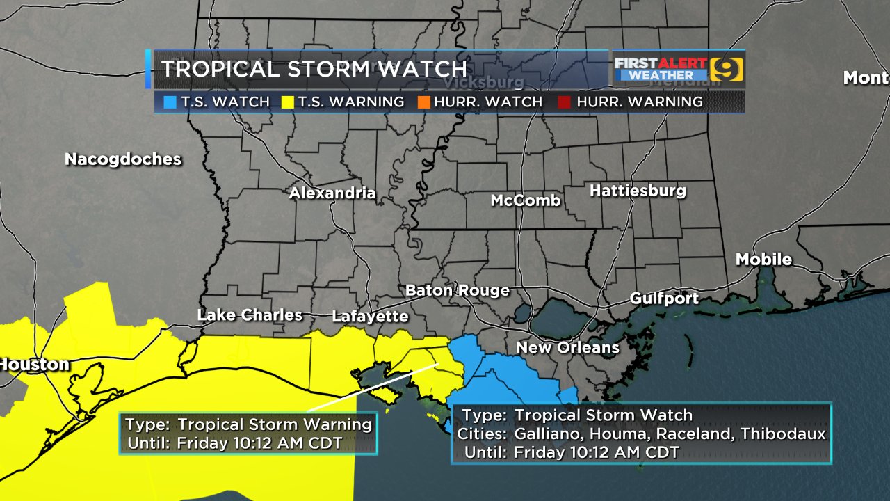
TS warning until Friday? I thought this would be gone by then.
Posted on 8/29/17 at 10:19 am to Janky
quote:
TS warning until Friday? I thought this would be gone by then.
Official forecast:

Posted on 8/29/17 at 10:20 am to Janky
quote:
warning until Friday? I thought this would be gone by then
This.... Wth??
Posted on 8/29/17 at 10:21 am to Janky
quote:
TS warning until Friday? I thought this would be gone by then.
Probably just erring on the side of caution with potential tropical storm winds through Friday. As the system moves out it will get elongated.
Posted on 8/29/17 at 10:21 am to Janky
Looking at the traffic camera @ I-45 and Cypresswood in Spring.
They are launching boats there.
They are launching boats there.
Posted on 8/29/17 at 10:22 am to Chad504boy
quote:
can't an overtopping of a levee of such epic quantities of water coming down river cause pretty vast and evasive damage to the levee itself pretty rapidly?
IF it's a complete earthen levee, there's a possibility of scouring, which could compromise the entire levee structure.
That's why after Katrina there was so much talk about fortifying the levees here with concrete overlay, etc.
Posted on 8/29/17 at 10:22 am to slackster
Kelli wood gardens is closer to the elaffected area than I am
Posted on 8/29/17 at 10:23 am to Jimbeaux28
Once it makes landfall will most of the rain be on the east side like with a hurricane?
Posted on 8/29/17 at 10:24 am to Janky

just insane
Posted on 8/29/17 at 10:24 am to chinhoyang
quote:
If the levee at Columbia Lakes is breaching now, they are in trouble. The river is going to rise, according to this, another ten feet!!!
Depending on the area that is flooded by the breach, the river's projected rise won't be as high, because the water, at least some of it, is diverted into Columbia Lakes.
Posted on 8/29/17 at 10:26 am to real turf fan
quote:
Depending on the area that is flooded by the breach, the river's projected rise won't be as high, because the water, at least some of it, is diverted into Columbia Lakes.
which in turn still makes its way back to brazos. brazos river just becomes wider.
Posted on 8/29/17 at 10:27 am to real turf fan
Colombia Lakes is south of Houston. Someone just said Addicks dam has water running over the top now.

 Page 549 of 618


Popular

Back to top
 Follow TigerDroppings for LSU Football News