- My Forums
- Tiger Rant
- LSU Recruiting
- SEC Rant
- Saints Talk
- Pelicans Talk
- More Sports Board
- Fantasy Sports
- Golf Board
- Soccer Board
- O-T Lounge
- Tech Board
- Home/Garden Board
- Outdoor Board
- Health/Fitness Board
- Movie/TV Board
- Book Board
- Music Board
- Political Talk
- Money Talk
- Fark Board
- Gaming Board
- Travel Board
- Food/Drink Board
- Ticket Exchange
- TD Help Board
Customize My Forums- View All Forums
- Show Left Links
- Topic Sort Options
- Trending Topics
- Recent Topics
- Active Topics
Started By
Message
 0
0

Posted on 8/24/17 at 11:49 pm to slackster
That's the fear, it slows down and strengthens. Harvey hasn't been moving very fast to begin with?
Posted on 8/24/17 at 11:49 pm to slackster
HRRR doesn't really show any skill with tropical systems but it is pretty cool to look at:

Posted on 8/24/17 at 11:49 pm to slackster
Well baws...I'm here in San Antonio. It won't be much better. It's hard to board up and leave any possessions behind. I hate that I became a materialistic person over the years.

Posted on 8/24/17 at 11:49 pm to slackster
quote:
It is supposed to slow down considerably over the next 24 hours
I guess we'll see!
Posted on 8/24/17 at 11:52 pm to rds dc
quote:
HRRR doesn't really show any skill with tropical systems but it is pretty cool to look at:
This is my kind of post.
Posted on 8/24/17 at 11:53 pm to RummelTiger
they went back and edited the 10 PM advsory... no new advisory until 1 AM... still 1 intermediate advisory for the time being
This post was edited on 8/24/17 at 11:56 pm
Posted on 8/24/17 at 11:53 pm to TexasTiger08
quote:
Well baws...I'm here in San Antonio. It won't be much better. It's hard to board up and leave any possessions behind. I hate that I became a materialistic person over the years.
Best of luck to you and yours.
Posted on 8/24/17 at 11:55 pm to rt3
western part of the eyewall... some purple starting to pop in

Posted on 8/24/17 at 11:56 pm to slackster
Thanks. I'm just trying to be content with things. I've done all I can do at this point.

Posted on 8/24/17 at 11:57 pm to TexasTiger08
Good luck. It is always hard to leave but everything but life can be replaced
Posted on 8/24/17 at 11:59 pm to rt3
quote:
western part of the eyewall... some purple starting to pop in
Very intense convective burst and the eastern portion of the core looks much better than earlier as that outer band has calmed down. It will be interesting to watch this unfold tonight. Looks much better than a few hours ago.
Posted on 8/24/17 at 11:59 pm to Ba Ba Boooey
quote:I know this is said with good intentions but it's simply not the case. I had to calm my wife down multiple times after the flood last year when friends said this to her.
It is always hard to leave but everything but life can be replaced

Posted on 8/24/17 at 11:59 pm to slackster
Where can I find the euro model track?

Posted on 8/25/17 at 12:01 am to Amazing Moves
TWC just updated it to a cat 2. 100mph winds.
Probably old news with all yall watching these models, but those of us that can't understand them, there it is.
Probably old news with all yall watching these models, but those of us that can't understand them, there it is.
Posted on 8/25/17 at 12:02 am to GRTiger
quote:
TWC just updated it to a cat 2. 100mph winds.
Probably old news with all yall watching these models, but those of us that can't understand them, there it is.
NHC just put out a special update
quote:
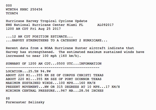
000
WTNT64 KNHC 250456
TCUAT4
Hurricane Harvey Tropical Cyclone Update
NWS National Hurricane Center Miami FL AL092017
1200 AM CDT Fri Aug 25 2017
...12 AM CDT POSITION ESTIMATE...
...HARVEY STRENGTHENS TO A CATEGORY 2 HURRICANE...
Recent data from a NOAA Hurricane Hunter aircraft indicate that
Harvey has strengthened. The estimated maximum sustained winds have
increased to near 100 mph (160 km/h).
SUMMARY OF 1200 AM CDT...0500 UTC...INFORMATION
----------------------------------------------
LOCATION...25.5N 94.9W
ABOUT 220 MI...355 KM SE OF CORPUS CHRISTI TEXAS
ABOUT 220 MI...355 KM SSE OF PORT OCONNOR TEXAS
MAXIMUM SUSTAINED WINDS...100 MPH...160 KM/H
PRESENT MOVEMENT...NW OR 315 DEGREES AT 10 MPH...17 KM/H
MINIMUM CENTRAL PRESSURE...967 MB...28.56 INCHES
$$
Forecaster Zelinsky

Posted on 8/25/17 at 12:03 am to GRTiger

Posted on 8/25/17 at 12:03 am to Amazing Moves
Winds up to 100 mph
Harvey turning on frick you mode
Harvey turning on frick you mode

Posted on 8/25/17 at 12:04 am to rt3
quote:
some purple starting to pop in
Wouldn't be SE TX storm with out some purp poppin'.
Trunks keep poppin', rain be droppin' down in Houston...
Posted on 8/25/17 at 12:08 am to slackster
Yikes. Get the pirogues out...

 Page 150 of 618

Popular
Back to top