- My Forums
- Tiger Rant
- LSU Recruiting
- SEC Rant
- Saints Talk
- Pelicans Talk
- More Sports Board
- Fantasy Sports
- Golf Board
- Soccer Board
- O-T Lounge
- Tech Board
- Home/Garden Board
- Outdoor Board
- Health/Fitness Board
- Movie/TV Board
- Book Board
- Music Board
- Political Talk
- Money Talk
- Fark Board
- Gaming Board
- Travel Board
- Food/Drink Board
- Ticket Exchange
- TD Help Board
Customize My Forums- View All Forums
- Show Left Links
- Topic Sort Options
- Trending Topics
- Recent Topics
- Active Topics
Started By
Message
re: Harvey ***Catastrophic Flooding Event***
Posted on 8/25/17 at 12:08 am to Clyde Tipton
Posted on 8/25/17 at 12:08 am to Clyde Tipton
Speaking of HTown, with this thing potentially strengthening: this would still just be a rain event for us right?
Got enough to worry about with the 20" rain projections. I don't want to think about strong winds
Got enough to worry about with the 20" rain projections. I don't want to think about strong winds
 1
1


Posted on 8/25/17 at 12:08 am to The Boat
quote:
Winds up to 100 mph
Harvey turning on frick you mode
yep.
12 AM Hurricane Center Update
This post was edited on 8/25/17 at 12:09 am

Posted on 8/25/17 at 12:09 am to TexasTiger08
Hey man good luck w everything. Good ppl in CC 
Anyone know if Powerman is still down there?
Anyone know if Powerman is still down there?

Posted on 8/25/17 at 12:11 am to Klark Kent
Always been a rain event for us unless it does some crazy shift.
Posted on 8/25/17 at 12:13 am to bigberg2000
How much rain did Denham/BR get during last yr's big storm?
Posted on 8/25/17 at 12:13 am to bigberg2000
cool, jus checking.
new house has a 60ft pine in the backyard and a 80ft pine in the front yard.
new house has a 60ft pine in the backyard and a 80ft pine in the front yard.
Posted on 8/25/17 at 12:14 am to slackster
quote:
Weather threads might be the most heavily modded threads on this site
Agree and am grateful. Trolling a stickied hurricane thread should have severe consequences. That is way worse than porn bombing.
I am following this thread for important updates instead of the news. It is more easily accessed, readable, better illustrated and more reliably cited than any other local online source.
I am scrolling through and just paying attention to the same 4 posters who only post well-cited gifs, links and updates. Posting comments/requests for advice about frickin flight plans or cruises is a waste of everyone's time at this point.

Posted on 8/25/17 at 12:15 am to LaBR4
Where can I find the euro model track? It's site etc..

Posted on 8/25/17 at 12:16 am to Amazing Moves
Posted on 8/25/17 at 12:18 am to OKellsBells
quote:Whoa. Agreed until here. Like you said, this is one of the better/quicker placers to get immediate info. While it may not be this thread specifically, people can at least point them to the travel board where Cuse has done a great job with the flight thread. It may not be life or death, but to that family, it's a big deal.
Posting comments/requests for advice about frickin flight plans or cruises is a waste of everyone's time at this point.
Posted on 8/25/17 at 12:20 am to RummelTiger
Thank you very much.
Posted on 8/25/17 at 12:21 am to Amazing Moves
You're welcome!

Posted on 8/25/17 at 12:21 am to Amazing Moves
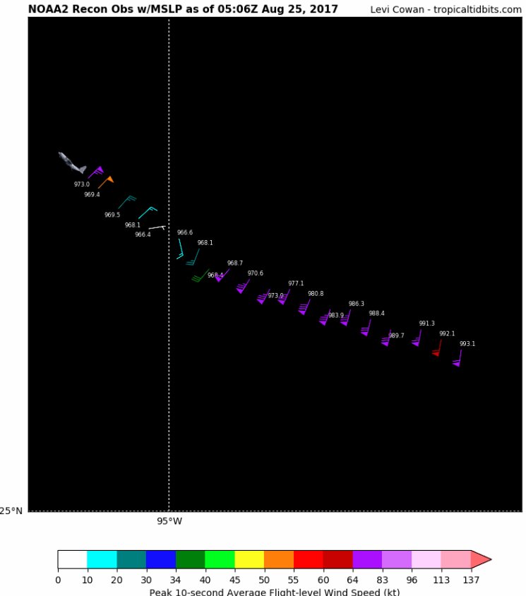
just keeps going lower and lower on each pass. You can see where the eye is calm, but has the lowest pressure.
This post was edited on 8/25/17 at 12:23 am
Posted on 8/25/17 at 12:23 am to ell_13
True. I see your point.
Posted on 8/25/17 at 12:24 am to The Boat
quote:
Winds up to 100 mph
Harvey turning on frick you mode
They're probably going higher soon. Recon found 88kt winds - 101mph - in the NW eye wall, but that dropsonde had 104kt winds not too far from the surface, and the average wind speed in the last 150m was 99kt - 115 MPH.
Usually see those winds make their way to the surface in a strengthening storm.
Posted on 8/25/17 at 12:27 am to S
quote:
Anyone know if Powerman is still down there?
Yeah actually he popped into this thread around 10:00 this morning. He still lives in Corpus. Was considering evacuating. Don't know if he did or not.
Posted on 8/25/17 at 12:27 am to slackster
quote:NOAA has found concentric eyewalls... if this thing keeps intensifying they close up and this thing bombs out. Stay safe out there.
Usually see those winds make their way to the surface in a strengthening storm.
Posted on 8/25/17 at 12:31 am to NYNolaguy1
That core is looking majorly put together right now. It'll be easily a major by 7 am if this keeps up.
Posted on 8/25/17 at 12:33 am to TexasTiger08
quote:
Well baws...I'm here in San Antonio. It won't be much better.
It sucks that you had to leave your stuff behind but you'll be much better there for now. SATX is 500' elevation and far enough inland that the wind will be much much much less. Just don't go driving around in it or immediately thereafter. I can't tell you how frustrating it is to see people drown that way when it's been said 1,000 times it's dumb to do. It's worse in and around SATX and ATX because of all the limestone creeks that are normally dry but become raging torrents.
This post was edited on 8/25/17 at 12:39 am
Posted on 8/25/17 at 12:33 am to NYNolaguy1
For those like me, who have no idea what concentric eyewalls mean:
quote:
Eyewall replacement cycles, also called concentric eyewall cycles, naturally occur in intense tropical cyclones, generally with winds greater than 185 km/h (115 mph), or major hurricanes (Category 3 or above). When tropical cyclones reach this intensity, and the eyewall contracts or is already sufficiently small, some of the outer rainbands may strengthen and organize into a ring of thunderstorms—an outer eyewall—that slowly moves inward and robs the inner eyewall of its needed moisture and angular momentum. Since the strongest winds are in a cyclone's eyewall, the tropical cyclone usually weakens during this phase, as the inner wall is "choked" by the outer wall. Eventually the outer eyewall replaces the inner one completely, and the storm may re-intensify.

 Page 151 of 618

Popular
Back to top