- My Forums
- Tiger Rant
- LSU Recruiting
- SEC Rant
- Saints Talk
- Pelicans Talk
- More Sports Board
- Fantasy Sports
- Golf Board
- Soccer Board
- O-T Lounge
- Tech Board
- Home/Garden Board
- Outdoor Board
- Health/Fitness Board
- Movie/TV Board
- Book Board
- Music Board
- Political Talk
- Money Talk
- Fark Board
- Gaming Board
- Travel Board
- Food/Drink Board
- Ticket Exchange
- TD Help Board
Customize My Forums- View All Forums
- Show Left Links
- Topic Sort Options
- Trending Topics
- Recent Topics
- Active Topics
Started By
Message
re: Francine - Landfall in Terrebonne Parish as CAT 2 100 mph
Posted on 9/11/24 at 7:38 am to imAMAZING
Posted on 9/11/24 at 7:38 am to imAMAZING
I am.
Evidently the little plant down the road sure ain't. They've been clearing all night i guess, sounded like I had an idling locomotive under my carport from 10pm till a few minutes ago.
Evidently the little plant down the road sure ain't. They've been clearing all night i guess, sounded like I had an idling locomotive under my carport from 10pm till a few minutes ago.
 1
1

Posted on 9/11/24 at 7:38 am to DownshiftAndFloorIt
Say baws, looks like they kinda missed on this one huh?
Posted on 9/11/24 at 7:39 am to ShoeBang
quote:
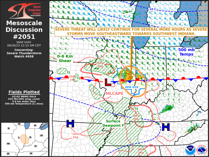
Mesoscale Discussion 2051 NWS Storm Prediction Center Norman OK 0719 AM CDT Wed Sep 11 2024 Areas affected...southeastern Louisiana coastal areas Concerning...Severe potential...Watch possible Valid 111219Z - 111545Z Probability of Watch Issuance...60 percent
SUMMARY...The risk for occasional tornadoes may begin to increase near southeastern Louisiana coastal areas by late morning (10 AM-Noon). Trends are being monitored for the possibility of a tornado watch.
DISCUSSION...The center of Francine has been migrating across and northeast of the Gunnison Oil Platform vicinity of the northwestern Gulf of Mexico during the past hour or so, and is still roughly 170 miles from its forecast south central Louisiana coastal landfall later today. However, the leading edge of a broader convective precipitation shield preceding Francine is beginning to overspread coastal areas, accompanied by saturating thermodynamic profiles with lapse rates trending moist adiabatic in mid-levels. In the wake of this regime, and with the continued approach of Francine, model forecast soundings suggest that a subtle increase in boundary-layer temperatures and dew points may contribute to modest destabilization by midday along coastal areas from west of Boothville into the Vermilion Bay vicinity. It appears that this will coincide with more notable strengthening of low-level wind fields, which are forecast to contribute to enlarging low-level hodographs increasingly supportive of convection with embedded low-level mesocyclones potentially capable of producing tornadoes.
Posted on 9/11/24 at 7:39 am to Thib-a-doe Tiger
quote:
Say baws, looks like they kinda missed on this one huh?
In what way?
Posted on 9/11/24 at 7:40 am to slackster
Glad to see high forward speed and no intensification as it nears shore
Nonetheless, a night storm sucks.
Nonetheless, a night storm sucks.
Posted on 9/11/24 at 7:40 am to rds dc
Does anyone have the current coordinates? I need to update my 1987 McDonald’s hurricane tracking map. I will also be coloring the weather this afternoon. Hopefully they show my picture on the news!!!

Posted on 9/11/24 at 7:40 am to Thib-a-doe Tiger
quote:
Say baws, looks like they kinda missed on this one huh?
Bingo!
Posted on 9/11/24 at 7:40 am to slackster
quote:
In what way?
Dude on Fox was saying wouldn’t get to a 2, now he’s expecting a 2
Posted on 9/11/24 at 7:40 am to Thib-a-doe Tiger
Peititon to add "Lafayette got lucky again" to the bingo card, yats.

Posted on 9/11/24 at 7:41 am to imAMAZING
quote:
So is everyone off work today? Because im sure aint
Technically I’m working but I work from home & don’t have much to do so far
Posted on 9/11/24 at 7:41 am to migui8618
quote:
Peititon to add "Lafayette got lucky again" to the bingo card, yats.
Wouldn’t call it luck, have you met anyone from Lafayette? Hurricanes don’t want to either
Posted on 9/11/24 at 7:42 am to Thib-a-doe Tiger
quote:
Dude on Fox was saying wouldn’t get to a 2, now he’s expecting a 2
Can anyone give some insight as to what factors would come into play to intensify this storm?
Posted on 9/11/24 at 7:43 am to Thib-a-doe Tiger
quote:
Dude on Fox was saying wouldn’t get to a 2, now he’s expecting a 2
Still may not get to a 2. It’s been predicted to be pretty close for a while, but +/- 5mph isn’t a huge deal.
Posted on 9/11/24 at 7:43 am to Alt26
quote:
need to update my 1987 McDonald’s hurricane tracking map.
1978 Schweggmans map
Posted on 9/11/24 at 7:43 am to PTLSU
quote:
I’ve yet to see a single model run or meteorologist on any news channel reporting winds in Nola exceeding 55mph, and even those winds wouldn’t last very long. I suppose it just depends on what people’s definition of “slammed” is.
And people have so little experience in wind they will insist the 50mph gust was 80.
Posted on 9/11/24 at 7:44 am to LegendInMyMind
Nola with a 12:00 pm curfew.. just said on WWL news
Posted on 9/11/24 at 7:44 am to Thib-a-doe Tiger
quote:
Say baws, looks like they kinda missed on this one huh?
The track has barely moved since 10am yesterday, not sure how that is blowing it
Posted on 9/11/24 at 7:44 am to SlidellCajun
quote:
Can anyone give some insight as to what factors would come into play to intensify this storm?
Somebody probably can. I was just saying, with a storm that has been kinda unpredictable that they shouldn’t go on tv and say “this won’t get to a cat 2”, and then 10 hours later the same guy is saying to expect a cat 2
Posted on 9/11/24 at 7:44 am to SlidellCajun
quote:
Can anyone give some insight as to what factors would come into play to intensify this storm?
Warm water, outflow channels, God wanting to frick Louisiana. The usual players.
Posted on 9/11/24 at 7:46 am to jaytothen
This girl on Fox in Jefferson is too cute to be out in this weather

 Page 299 of 492

Popular
Back to top