- My Forums
- Tiger Rant
- LSU Recruiting
- SEC Rant
- Saints Talk
- Pelicans Talk
- More Sports Board
- Fantasy Sports
- Golf Board
- Soccer Board
- O-T Lounge
- Tech Board
- Home/Garden Board
- Outdoor Board
- Health/Fitness Board
- Movie/TV Board
- Book Board
- Music Board
- Political Talk
- Money Talk
- Fark Board
- Gaming Board
- Travel Board
- Food/Drink Board
- Ticket Exchange
- TD Help Board
Customize My Forums- View All Forums
- Show Left Links
- Topic Sort Options
- Trending Topics
- Recent Topics
- Active Topics
Started By
Message

 0
0

Posted on 9/7/24 at 12:33 am to SWLA92
Boo this man.
Posted on 9/7/24 at 12:49 am to BregmansWheelbarrow
Tropical Weather Outlook
NWS National Hurricane Center Miami FL
200 AM EDT Sat Sep 7 2024
For the North Atlantic...Caribbean Sea and the Gulf of Mexico:
1. Southwestern Gulf of Mexico:
A tropical wave over the Yucatan Peninsula of Mexico is producing
disorganized showers and thunderstorms over Guatemala, southeastern
Mexico, and the adjacent waters of the southwestern Gulf of Mexico.
The wave is expected to move over the Bay of Campeche later today,
and an area of low pressure is forecast to develop while interacting
with a frontal boundary. Environmental conditions are forecast to be
conducive for development, and a tropical depression could form
during the early or middle part of next week while the system moves
slowly northwestward over the southwestern Gulf of Mexico.
* Formation chance through 48 hours...medium...40 percent.
* Formation chance through 7 days...medium...60 percent.
Posted on 9/7/24 at 12:59 am to lsuman25
starting to look like a possible TS hitting and stalling along SE texas SW LA coast next wednesday... not strong wind, but i have a feeling we will start getting some eye opening rainfall predictions soon.
might as well get supplied up sooner rather later.
might as well get supplied up sooner rather later.
This post was edited on 9/7/24 at 8:50 am

Posted on 9/7/24 at 5:38 am to CoonassatTEXAS

Not quite hurricane status but good formation
Posted on 9/7/24 at 5:39 am to mylsuhat
06 GFS has a hurricane near Texas Louisiana border on the 12. Actually looks like it weakens before reaching the coast though
This post was edited on 9/7/24 at 5:48 am

Posted on 9/7/24 at 6:48 am to mylsuhat
frick me H-E-B is going to a war zone when I get back to Houston on Sunday

Posted on 9/7/24 at 6:57 am to mylsuhat
Why you selected wind speeds 250 m above ground baw? Trying to scare people?
Posted on 9/7/24 at 7:19 am to Cosmo
Shows the circulation better just like the satellite would
You think the hurricane hunter planes fly at 10m when they are taking measurements?
You think the hurricane hunter planes fly at 10m when they are taking measurements?
This post was edited on 9/7/24 at 7:24 am
Posted on 9/7/24 at 7:30 am to mylsuhat
quote:
You think the hurricane hunter planes fly at 10m when they are taking measurements?
No but they extrapolate surface measurements.
Posted on 9/7/24 at 8:19 am to CoonassatTEXAS
quote:
starting to look like a possible TS hitting and stalling along NE texas SW LA coast next wednesday... not strong wind, but i have a feeling we will start getting some eye opening rainfall predictions soon. might as well get supplied
No model shows it stalling
8-10in in the worst spots is what you will see

Posted on 9/7/24 at 8:20 am to rds dc


Posted on 9/7/24 at 9:25 am to rds dc
Booooooooo
Posted on 9/7/24 at 10:29 am to Mr Happy
Rummy getting a bit of a boner at austin rain possibilities
Posted on 9/7/24 at 10:36 am to Mr Happy
This morning’s Icon run shifted 91L over to Vermilion Bay. Strength looks like a TS.
Posted on 9/7/24 at 10:37 am to udtiger
This system will be interacting with a shortwave trough coming out of Texas. The 00z Euro has a positively tilted progressive s/w, and the 06z has a more neutral and slower s/w. The latter allows the system to briefly experience a favorable upper air pattern with an enhanced outflow channel for strengthening. Either way, proximity to land and the upper level air pattern probably limits 91Ls potential before it is swept away.
00z Euro
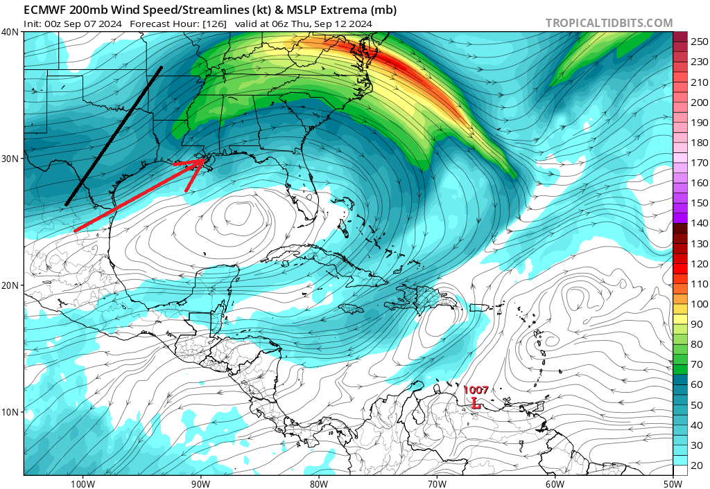
06z GFS
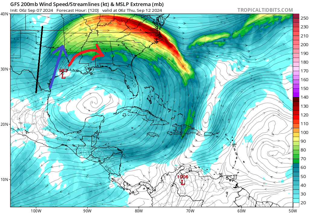
00z Euro
06z GFS
Posted on 9/7/24 at 10:42 am to rds dc
06z GFS the strongest run out of all the models. Curious to see what the 12z runs looks like. ICON so far looked a tad stronger still a TS
Posted on 9/7/24 at 10:44 am to rds dc
So rds is saying a sloppy rain making nothingburger
Printing the shirts
Printing the shirts
Posted on 9/7/24 at 11:05 am to SWLA92
12Z GFS coming in stronger

Posted on 9/7/24 at 11:06 am to Cosmo
quote:
So rds is saying a sloppy rain making nothingburger
What are his thoughts on this GFS run?

 Page 24 of 492

Popular
Back to top