




- My Forums
- Tiger Rant
- LSU Recruiting
- SEC Rant
- Saints Talk
- Pelicans Talk
- More Sports Board
- Fantasy Sports
- Golf Board
- Soccer Board
- O-T Lounge
- Tech Board
- Home/Garden Board
- Outdoor Board
- Health/Fitness Board
- Movie/TV Board
- Book Board
- Music Board
- Political Talk
- Money Talk
- Fark Board
- Gaming Board
- Travel Board
- Food/Drink Board
- Ticket Exchange
- TD Help Board
Customize My Forums- View All Forums
- Show Left Links
- Topic Sort Options
- Trending Topics
- Recent Topics
- Active Topics
Started By
Message
re: February 2019 Cold blast and southern snow discussion thread
Posted on 1/26/19 at 2:45 pm to jimmy the leg

Posted on 1/26/19 at 2:45 pm to jimmy the leg
quote:
I wonder how long the school systems will wait to determine what to do
I have a relative who is in charge of transportation forva rural school system. On weather days he is up 4 AM checking the roads. The first buses are running by 6 so the decision has to be made before then.
 0
0

Posted on 1/26/19 at 3:44 pm to Mudminnow
Let’s not start trashing up the thread with this bullshite

Posted on 1/26/19 at 3:52 pm to jimmy the leg
My God
Wanting to cancel the city for a light snow drizzle
Get a grip
Wanting to cancel the city for a light snow drizzle
Get a grip


Posted on 1/26/19 at 3:55 pm to East Coast Band
quote:
This solution looks WAY more like a snow potential than some other models on the previous pages.
Anytime the snow is predicted from the outset, not a rain first/ change over to snow solution, it is more likely.
However, the big question should be the precipitation total. These Arctic fronts tend to dry out things, therefore I can't imagine a lot of precipitation with the system on Tuesday.
I’m genuinely curious how it’s setting up for us here in Louisville. There’s already an outside chance of a school cancellation due to wind chills on Wednesday, but it’ll be worse if there’s snow on the ground.
This post was edited on 1/26/19 at 3:56 pm

Posted on 1/26/19 at 4:29 pm to Mudminnow
quote:
The road crews will do the same thing for a light dusting as they do in all states, nothing.
Here's a half inch thick and a mile-long bit of sheet ice from the last light dusting we had

I was able to do 60 miles an hour Donuts on my buggy

Posted on 1/26/19 at 6:45 pm to X123F45
yep... snow still there in the 18z GFS



Posted on 1/26/19 at 8:44 pm to rt3
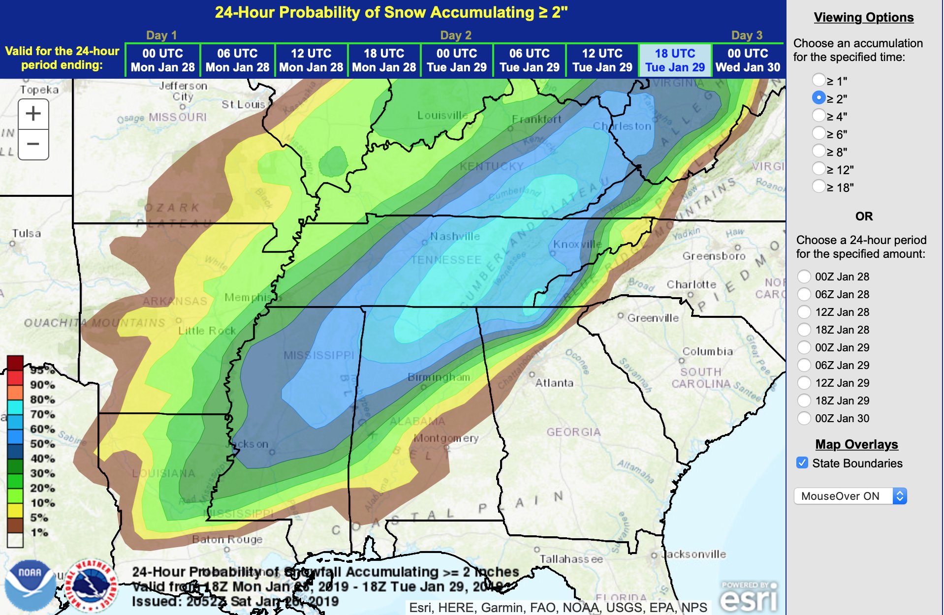
Saw this from a couple hours ago.
Posted on 1/26/19 at 9:20 pm to bayoubengals88
From the Chicago NWS forecast discussion...good thing it is not going to dip this far south.
.LONG TERM...
158 PM CST
Tuesday through Saturday...
Record breaking to perhaps historic cold outbreak still on track
for mid week.
Medium range models remain generally in good agreement in bringing
in a period of record breaking cold, though there are some minor
differences in the details in the models. For days now, the GFS
and GFS-FV3 have remained on the cold end of the spectrum with 2m
advertising fairly widespread -30F temps Wed morning across the
northern CWA and keeping temps at or below -20 all day Wednesday.
These readings don`t just break records, but in some cases shatter
the all-time records. The ECMWF has been and the latest continues
to be more reasonable with 2m temps but still advertises
widespread temps at or below -20F Tues night/Wed AM and again Wed
night/Thur AM.
The ECMWF, GEM, FV3, and GFS all continue advertise all time
record cold 850mb temps and 500mb heights based on the SPC
sounding climo tool. These forecast values have shown some slight
variability from run to run over the past several days, but the
variability has mainly all been within record territory and just a
matter of how much lower than records the values progged are.
Given the run to run consistency and the consistency among the
various medium range models and their respective ensembles, it is
growing increasingly difficult to refrain from forecasting near
all time record temperatures.
Generally speaking, raw 2m temps from the various models
outperform any MOS type products during periods of extreme
temperatures. Have continued to gradually trend the forecast
closer to the model consensus of 2m temps, but still stayed a bit
warmer than the mean and much warmer than the coldest guidance
(GFS & FV3). While remaining warmer than the mean of 2m temp
guidance, we still are now officially forecasting record tying
all time cold high temps Wed at both RFD and ORD. Wind chills
should easily drop into the -35 to -45 range with some -50 degree
wind chills possible, especially Wednesday morning.
.LONG TERM...
158 PM CST
Tuesday through Saturday...
Record breaking to perhaps historic cold outbreak still on track
for mid week.
Medium range models remain generally in good agreement in bringing
in a period of record breaking cold, though there are some minor
differences in the details in the models. For days now, the GFS
and GFS-FV3 have remained on the cold end of the spectrum with 2m
advertising fairly widespread -30F temps Wed morning across the
northern CWA and keeping temps at or below -20 all day Wednesday.
These readings don`t just break records, but in some cases shatter
the all-time records. The ECMWF has been and the latest continues
to be more reasonable with 2m temps but still advertises
widespread temps at or below -20F Tues night/Wed AM and again Wed
night/Thur AM.
The ECMWF, GEM, FV3, and GFS all continue advertise all time
record cold 850mb temps and 500mb heights based on the SPC
sounding climo tool. These forecast values have shown some slight
variability from run to run over the past several days, but the
variability has mainly all been within record territory and just a
matter of how much lower than records the values progged are.
Given the run to run consistency and the consistency among the
various medium range models and their respective ensembles, it is
growing increasingly difficult to refrain from forecasting near
all time record temperatures.
Generally speaking, raw 2m temps from the various models
outperform any MOS type products during periods of extreme
temperatures. Have continued to gradually trend the forecast
closer to the model consensus of 2m temps, but still stayed a bit
warmer than the mean and much warmer than the coldest guidance
(GFS & FV3). While remaining warmer than the mean of 2m temp
guidance, we still are now officially forecasting record tying
all time cold high temps Wed at both RFD and ORD. Wind chills
should easily drop into the -35 to -45 range with some -50 degree
wind chills possible, especially Wednesday morning.
Posted on 1/26/19 at 9:25 pm to NorthEndZone
quote:
From the Chicago NWS forecast discussion...good thing it is not going to dip this far south.
just get a sweater... you'll be ok
Posted on 1/26/19 at 9:29 pm to NorthEndZone
The discussions up that way from Chicago to the Twin Cities are pretty ridiculous reads.
Our little possibly snowy front forecast looks pretty reasonable, room to go a little colder and spread farther south but even then can't imagine it's enough to have much impact along the 10-12-190. Basically the farther north the better in La.
Our little possibly snowy front forecast looks pretty reasonable, room to go a little colder and spread farther south but even then can't imagine it's enough to have much impact along the 10-12-190. Basically the farther north the better in La.

Posted on 1/26/19 at 9:51 pm to Duke
00z GFS running now... yep southern snow is still here


Posted on 1/26/19 at 11:41 pm to rt3
You probably don't want to see the snowfall map though, because it's not much of anything for Alexandria or even much in Monroe. NAM was even leaner. Managing expectations here, as the runs look about the same but the soundings coming off of at least the GFS kinda sucks still.
Still think forecast adjustments are would favor more snow for areas and not less though.
Still think forecast adjustments are would favor more snow for areas and not less though.

Posted on 1/27/19 at 12:07 am to Duke
quote:
Duke
What are your thoughts on the B'ham area? Spann seems to be saying .5" to an 1.5". Looks like we should expect travel conditions to be affected regardless of snowfall due to precipitation followed by freezing temps.
Posted on 1/27/19 at 12:15 am to wareagle47
Apparently on his Twitter he upped it to 2" potential. He is often really conservative on snow totals this far out. Another met was saying he saw indications of enhanced lift somewhere in a sweet spot between Cullman and Calera to snag between 2"-4" which is not uncommon even in a set up like this where it isn't a Gulf system.
Posted on 1/27/19 at 12:20 am to wareagle47
quote:
Spann seems to be saying .5" to an 1.5".
Hard to go wrong with Spann anyway, and that seems to line up with what the models are spitting out. The good side of the forecast to be as cold as it is, there isn't any question to travel impacts, you know there going to be a thing. The finer details on totals will show themselves in the next couple of days. Haven't look at model runs close enough to give you more at this point for the Bham area.
So get that milk and bread and don't go driving if you don't need to.
This post was edited on 1/27/19 at 12:22 am

Posted on 1/27/19 at 8:53 am to Duke
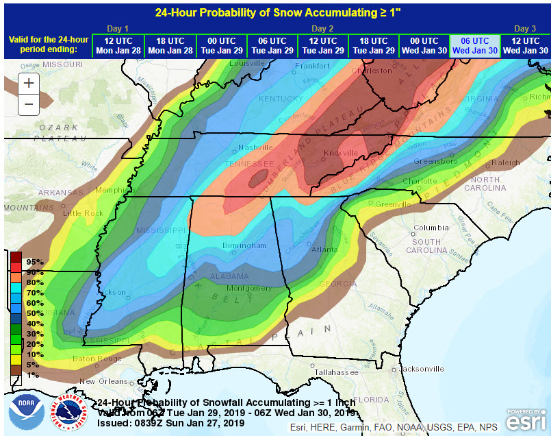
Here’s the update this morning
Posted on 1/27/19 at 9:41 am to Duke
quote:
You probably don't want to see the snowfall map though, because it's not much of anything for Alexandria or even much in Monroe. NAM was even leaner. Managing expectations here, as the runs look about the same but the soundings coming off of at least the GFS kinda sucks still.
Still think forecast adjustments are would favor more snow for areas and not less though.
honestly... I don't care how much snow I get... I want just enough to see some flakes fall and get that little dusting on the grass so everything looks picturesque
I'm not asking for much
Posted on 1/27/19 at 9:47 am to rt3
NWS Lake Charles discussion this morning
quote:
Long Term...Monday Night through Saturday...
The main weather feature of interest will be this low pressure`s
cold front which will push through the CWA late Monday night
through Tuesday morning. This cold front will usher an arctic
airmass into the region accompanied by over-running precipitation.
Forecast model soundings continue to indicate that there will be
a 3-6 hour period where the temperature profile could be
supportive of some snow. However, this will coincide with the time
period that precipitation is exiting the region and the
atmospheric column dries. This will likely limit the potential of
a more robust winter weather event.
Currently, the greatest likelihood for snow to mix into and/or
completely change over from the rain Monday night into Tuesday
morning will be across central Louisiana. Similar to winter
weather events in this area over the past two to three years, any
accumulating snowfall will likely be dependent on the development
of mesoscale snow bands which simply cannot be predicted this far
in advance. However, the majority of model guidance indicates at
least some potential for snow accumulation across Rapides (
Avoyelles Parishes in the northeast portion of the CWA. Ensemble
plumes for this portion of the CWA have mean snowfall
accumulations ranging from 0.25" to 0.5", with higher end totals
of 1" to 2". Therefore, this forecast package did include snowfall
accumulations up to 0.3" in the northeast corner of the CWA.
Details regarding any potential snowfall should *hopefully* become
clearer as time to the event gets closer. Continue to monitor the
forecast for future updates on the potential for snowfall and
possible accumulations.
The more significant impact from this system will be much colder
temperatures during the second half of next week. Model guidance
is forecasting 850 hPa standardized anomalies of -1 to -2 sigma
over the region during the middle part of next week. The coldest
temperatures are expected Tuesday night into Wednesday morning,
when several hours of below freezing temperatures are expected. A
hard freeze will also be possible across portions of Central
Louisiana.
Beyond Thursday, uncertainty in the upper level pattern increases
as model guidance is depicting a wider variety in the strength
and paths of the next series of shortwave troughs that will move
across the CONUS. Therefore, the later half of the forecast was
made up of a blend of WPC and NBM guidance. This results in
chance/slight chance PoPs beginning on Thursday and continuing
through Saturday. While it is unlikely that rainfall will occur
through the entirety of this period, there is at least the
potential for some showers during this timeframe. Temperatures
during the later half of next week are currently expected to be
near to slightly below average.
Posted on 1/27/19 at 10:19 am to rt3
So when does ebr schools close?

Posted on 1/27/19 at 11:22 am to NorthEndZone
Here come the ducks!

 Page 11 of 29

Popular
Back to top
 Follow TigerDroppings for LSU Football News