- My Forums
- Tiger Rant
- LSU Recruiting
- SEC Rant
- Saints Talk
- Pelicans Talk
- More Sports Board
- Fantasy Sports
- Golf Board
- Soccer Board
- O-T Lounge
- Tech Board
- Home/Garden Board
- Outdoor Board
- Health/Fitness Board
- Movie/TV Board
- Book Board
- Music Board
- Political Talk
- Money Talk
- Fark Board
- Gaming Board
- Travel Board
- Food/Drink Board
- Ticket Exchange
- TD Help Board
Customize My Forums- View All Forums
- Show Left Links
- Topic Sort Options
- Trending Topics
- Recent Topics
- Active Topics
Started By
Message

 2
2

Posted on 6/16/23 at 5:23 am to LSUGrrrl
Idk that I’ve ever seen a regular thunderstorm be that bad. May have been deracheo or however it’s spelled
Posted on 6/16/23 at 5:32 am to Tigerpride18
Nasty shite. Line just passed, felt hurricane like. My weather station picked up 46 gusts.

Posted on 6/16/23 at 5:35 am to Twincam
I’m not sure if this technically qualifies as a derecho, but this line blowing through Jackson now is bad like a derecho. The severe thunderstorm warnings say winds could gust to 80 mph.
This post was edited on 6/16/23 at 5:36 am

Posted on 6/16/23 at 5:52 am to Roll Tide Ravens
My lights flickered several times

Posted on 6/16/23 at 6:04 am to Tigerpride18
quote:
Idk that I’ve ever seen a regular thunderstorm be that bad. May have been deracheo or however it’s spelled
For a squall line to be considered a derecho - It has to be 240+ miles in length and have wind gusts exceeding 58mph that entire length.
This system appears to be split into a couple three different cells of slightly varying intensity.
Posted on 6/16/23 at 6:57 am to yurintroubl
The lightning that flashed for 20 minutes was absolutely crazy. We’re very blessed to lose power and have small medium sized limbs down.
My dad’s driveway is covered in a neighbors tree. I’ll be there soon sawing it up.
My dad’s driveway is covered in a neighbors tree. I’ll be there soon sawing it up.
Posted on 6/16/23 at 7:07 am to Strannix
That weather map still has Ft Polk listed.
I wonder how long until someone complains??

Posted on 6/16/23 at 7:16 am to rmnldr
quote:
Is it even a derecho or just a wind bag?
I bet the NWS will do a write up on it, it wanted to derecho but it was more of a supercell cluster. Maybe one of experts can chime in

Posted on 6/16/23 at 7:18 am to LSUGrrrl
That was pretty rough. No electricity in Benton
Posted on 6/16/23 at 7:25 am to Twincam
Supposedly they clock wind at 128.6 mph near I-20 around 2am.
Posted on 6/16/23 at 7:36 am to carhartt
I heard continuous rolling thunder for half an hour
Posted on 6/16/23 at 8:33 am to Strannix
As it rolled into Shreveport:
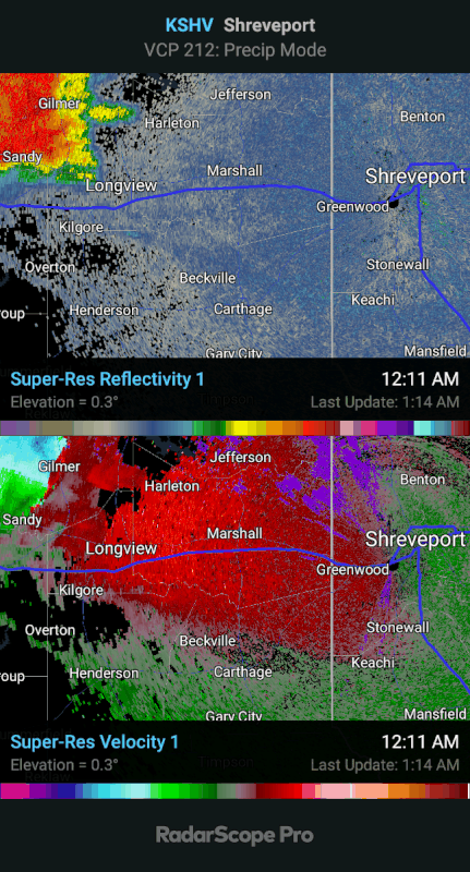
That slight gravity wave or boundary moving in from the SSW amplified the storm on approach. Prior to that the top end had come down and the southern part of the storm was warned for 60mph winds. When that boundary came through and collided with the storm it ramped up again with winds aloft ~130mph. The northern extent got warned for 90mph+ winds and the southern part got bumped back to 70mph. I have the warnings turned off on this loop, but there were plenty of them.
Also, there was likely a brief tornado on the southern side following this loop. The boundary/wave interacted with an already present hook/notch and caused the couplet to tighten. It only lasted for two or three frames. It did get warned, but that warning was after it looked the "best". I didn't get a screen grab of it, but it would have been somewhere between Greenwood and Stonewall....I think.
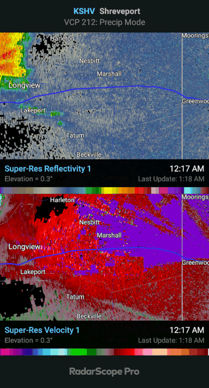
I'm glad everyone seems to be safe and accounted for this morning. Brother Salmon, thank God you're all safe, but I hate the damage done to your home. I wish you the best of luck and hope everything goes as smoothly as possible moving forward.
This is why a weather radio is a must. We're just too prone to turn off the notifications on our phones or put it on Do No Disturb while we're sleeping. This storm rolled through in the middle of the night. It started as an inconspicuous line of severe storms nearly 500 miles away. It ebbed and flowed as far as severity went, and was an easier one to dismiss. Warnings for a destructive severe storm were issued well in advance. That weather radio, properly programmed, would have been there to alert everyone to those warnings. They can be annoying, but they can also save lives. Think about it.
Wishing everyone the best with cleanup and repair.
That slight gravity wave or boundary moving in from the SSW amplified the storm on approach. Prior to that the top end had come down and the southern part of the storm was warned for 60mph winds. When that boundary came through and collided with the storm it ramped up again with winds aloft ~130mph. The northern extent got warned for 90mph+ winds and the southern part got bumped back to 70mph. I have the warnings turned off on this loop, but there were plenty of them.
Also, there was likely a brief tornado on the southern side following this loop. The boundary/wave interacted with an already present hook/notch and caused the couplet to tighten. It only lasted for two or three frames. It did get warned, but that warning was after it looked the "best". I didn't get a screen grab of it, but it would have been somewhere between Greenwood and Stonewall....I think.
I'm glad everyone seems to be safe and accounted for this morning. Brother Salmon, thank God you're all safe, but I hate the damage done to your home. I wish you the best of luck and hope everything goes as smoothly as possible moving forward.
This is why a weather radio is a must. We're just too prone to turn off the notifications on our phones or put it on Do No Disturb while we're sleeping. This storm rolled through in the middle of the night. It started as an inconspicuous line of severe storms nearly 500 miles away. It ebbed and flowed as far as severity went, and was an easier one to dismiss. Warnings for a destructive severe storm were issued well in advance. That weather radio, properly programmed, would have been there to alert everyone to those warnings. They can be annoying, but they can also save lives. Think about it.
Wishing everyone the best with cleanup and repair.
Posted on 6/16/23 at 8:35 am to Strannix
I live close to downtown Tyler
I heard the wind and thunder but not much rain.
Didn’t lose any power but where I work in gladewater yeah there’s power outages
I heard the wind and thunder but not much rain.
Didn’t lose any power but where I work in gladewater yeah there’s power outages

Posted on 6/16/23 at 8:38 am to Salmon
quote:shite. Was the bike hanging on the wall in the back or front half?
The front part of the house is fine. The back half is a complete rebuild though.
Just trying to give you a chuckle through a tough time

Posted on 6/16/23 at 9:16 am to LegendInMyMind
quote:
This is why a weather radio is a must.
yep
Posted on 6/16/23 at 10:27 am to Strannix
Friend works for SWEPCO in Shreveport. Said they tracked winds as high as 97 mph and the average was 80 mph in Bossier and Shreveport. One of the power stations does not have power so they have to get it up and running first so once lines are repaired people will actually have power to get.
Posted on 6/16/23 at 10:33 am to LaPlace Mafia
Over 560,000 customers out of power in TX, LA, MS
LA Power Outages
TX Power Outages
MS Power Outages
LA Power Outages
TX Power Outages
MS Power Outages
Posted on 6/16/23 at 10:47 am to NorthEndZone
I know we have some posters down on the beach in GS, OB, and PCB. That stretch got hammered with 15-17" of rain with hourly rates approaching 5"/hr at times.
Posted on 6/16/23 at 11:02 am to NorthEndZone
From Sanger, TX last night:


 Page 2 of 7

Popular
Back to top