




- My Forums
- Tiger Rant
- LSU Recruiting
- SEC Rant
- Saints Talk
- Pelicans Talk
- More Sports Board
- Fantasy Sports
- Golf Board
- Soccer Board
- O-T Lounge
- Tech Board
- Home/Garden Board
- Outdoor Board
- Health/Fitness Board
- Movie/TV Board
- Book Board
- Music Board
- Political Talk
- Money Talk
- Fark Board
- Gaming Board
- Travel Board
- Food/Drink Board
- Ticket Exchange
- TD Help Board
Customize My Forums- View All Forums
- Show Left Links
- Topic Sort Options
- Trending Topics
- Recent Topics
- Active Topics
Started By
Message
re: Collection of Satellite Photos of Katrina damage (new topic as suggested)
Posted on 8/25/15 at 3:26 pm to Artie Rome


Posted on 8/25/15 at 3:26 pm to Artie Rome
Should've just bulldozed the entire city.
 1
1


Posted on 8/25/15 at 3:28 pm to Bleeding purple
quote:we were being escorted for most of the photo mission by 4 F16's because Airforce 1 was in the air over the city with us. You are not supposed to share the same airspace with the President but they made an exception for us. But they kept us closely guarded
Yep. my dad was flying that one too. He said he had some small arms fire but nothing hit the plane.
 .
. I have some 8mm video footage somewhere of AF1 flying over Lake Pontchartrain just off our right side wing tip


Posted on 8/25/15 at 3:28 pm to udtiger
I'm in this picture. (Okay, I'm almost certainly in a small trailer - and the trailer is in this picture.)

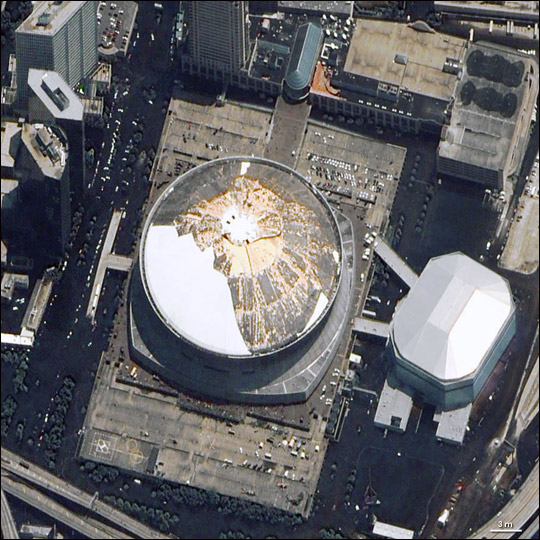
This post was edited on 8/25/15 at 3:29 pm
Posted on 8/25/15 at 3:30 pm to TigerWise
To be serious for a moment, I can't pull myself away from the coverage. I was in BR during everything. Lost power for maybe 12 hours. But seeing the devastation, and having so many loved ones lose everything, is still the most surreal thing I have ever experienced. 9/11 was a blip compared to Katrina on a personal level.

Posted on 8/25/15 at 3:34 pm to Artie Rome
Right in the center of this pic is a small, private airport very close to where I grew up. shite got wrecked there.
(click pic for full size)
LINK ]
(click pic for full size)
LINK ]

Posted on 8/25/15 at 3:40 pm to Artie Rome
She gone baw.
Posted on 8/25/15 at 3:42 pm to Tiger Ryno
I-10 twinspan:

I-10 / I-610 split

17th Street Canal breach and Lakefront

I-10 / I-610 split
17th Street Canal breach and Lakefront
This post was edited on 8/25/15 at 3:49 pm
Posted on 8/25/15 at 3:43 pm to GeauxColonels
Biloxi

Posted on 8/25/15 at 3:45 pm to meauxjeaux2
quote:
Biloxi
Just looked at some there....the debris is unreal.


Posted on 8/25/15 at 3:45 pm to udtiger
Pass Christian/Henderson Point (90 bridge and railroad trestle - gone [along with almost all structures]).


Posted on 8/25/15 at 3:48 pm to meauxjeaux2
quote:
These are my copyrighted images and are not to be used or resold.
I'm sorry. I just sold it.

Posted on 8/25/15 at 3:51 pm to udtiger
Gulfport

Posted on 8/25/15 at 3:53 pm to GeauxColonels

This took me way too long to find.
Posted on 8/25/15 at 3:59 pm to GaryMyMan
City Park (Tad Gormley Stadium)

Fair Grounds

Fair Grounds


Posted on 8/25/15 at 4:05 pm to udtiger
That is just way too much clicking and not enough information as far as landmarks, etc.

Posted on 8/25/15 at 4:34 pm to udtiger
I want to say google maps temporarily had up fresh satellite images of the damaged areas for a time being... because in these - I don't really see the damage around my folks' neighborhood on the Northshore... but all the downed trees that were blocking the roads in the weeks following the storm were EASILY spotted when I searched at the time.
Thought my folks' house was GONE... but it was just all the debris that collected around the house obscured what I was looking at.
Thought my folks' house was GONE... but it was just all the debris that collected around the house obscured what I was looking at.

Posted on 8/25/15 at 5:06 pm to yurintroubl
It would be cool to see a satellite picture of the pile of debris on west end. It was like a mountain of of crap

Posted on 8/25/15 at 5:39 pm to HeadBusta4LSU
That it was. It had to be 30-40 feet high, 75 yards wide and many many blocks long.
I wish I'd have taken a picture of it.
I wish I'd have taken a picture of it.


Posted on 8/25/15 at 5:50 pm to Jake88
Jesus... just looked up my old boss's place in Waveland.
That whole area was completely flattened. Gone.
That whole area was completely flattened. Gone.
Posted on 8/25/15 at 6:05 pm to BoostAddict
Yep, between the tracks and the beach in Waveland was ground zero. The Jourdan river probably had a higher storm surge, but people only say that since there was shite left to measure it off of. It was ~29' at my house in Old Town BSL.

 Page 2 of 3

Popular
Back to top
 Follow TigerDroppings for LSU Football News