- My Forums
- Tiger Rant
- LSU Recruiting
- SEC Rant
- Saints Talk
- Pelicans Talk
- More Sports Board
- Coaching Changes
- Fantasy Sports
- Golf Board
- Soccer Board
- O-T Lounge
- Tech Board
- Home/Garden Board
- Outdoor Board
- Health/Fitness Board
- Movie/TV Board
- Book Board
- Music Board
- Political Talk
- Money Talk
- Fark Board
- Gaming Board
- Travel Board
- Food/Drink Board
- Ticket Exchange
- TD Help Board
Customize My Forums- View All Forums
- Show Left Links
- Topic Sort Options
- Trending Topics
- Recent Topics
- Active Topics
Started By
Message
re: Category 5 Hurricane Melissa - 185 mph, 892mb, Top 3 in Recorded History
Posted on 10/27/25 at 7:31 am to DeCat ODahouse

Posted on 10/27/25 at 7:31 am to DeCat ODahouse
quote:
Same words were said about another 3rd World locale after a hurricane in 2005.
True, but TPTB bowed to the race hucksters and consciously refused to try and improve the place when the opportunity was presented.
 0
0

Posted on 10/27/25 at 8:19 am to DeCat ODahouse
quote:
Same words were said about another 3rd World locale after a hurricane in 2005.
Thankfully we have a leader who won't import thousands of Jamaicans under the guise of "climate change disaster refugees".

Posted on 10/27/25 at 8:31 am to Turnblad85

Posted on 10/27/25 at 9:22 am to Bobby OG Johnson
Dropsonde measured 151 knot (173.8 mph) winds at surface in NE eyewall. I wonder if they officially go with 150 knots at next advisory.
Incredible storm.
 >
>
Incredible storm.
>This post was edited on 10/27/25 at 9:27 am
Posted on 10/27/25 at 9:30 am to NorthEndZone
Look at these dropsonde readings
210 kt at 907mb
Not a record though. Katrina had a reading of 234 kt
AF Recon plane just completed a center pass. New data is arriving now.
909.5mb extrap pressure. She's getting angry

210 kt at 907mb
Not a record though. Katrina had a reading of 234 kt
AF Recon plane just completed a center pass. New data is arriving now.
909.5mb extrap pressure. She's getting angry

Posted on 10/27/25 at 9:51 am to Disco Ball
(no message)
Posted on 10/27/25 at 9:52 am to CarolinaGamecock99
165mph, 908 mb is nuts
Posted on 10/27/25 at 9:56 am to Disco Ball
That is insane
Posted on 10/27/25 at 9:58 am to Disco Ball
quote:
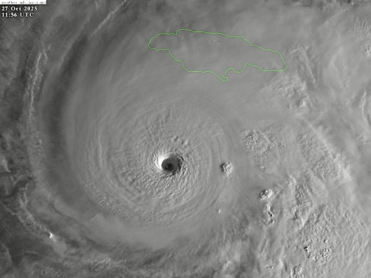
Hurricane Melissa Discussion Number 25
NWS National Hurricane Center Miami FL AL132025
1100 AM EDT Mon Oct 27 2025
Melissa has the classic strong hurricane appearance in satellite
imagery this morning, with a well-defined 10-nm wide eye embedded
in a central dense overcast with cloud tops colder than -80C. The
hurricane also has a large complex of outer banding over the
eastern semicircle and a circulation that covers most of the
Caribbean west of 70 degrees west longitude. Reports from NOAA and
Air Force Reserve Hurricane Hunter aircraft indicate the central
pressure has fallen to near 908 mb, with both aircraft releasing
dropsondes in the northeastern eyewall that support an initial
intensity of 145 kt. The NOAA aircraft left the storm early after
experiencing severe turbulence in the southwestern eyewall.
The eye is wobbling around due to the slow motion, but the best
estimate of the initial motion is 270/3 kt. The mid-level ridge
north of Melissa is weakening as a deep-layer mid-latitude trough
moves eastward through the southeastern United States. This should
cause the hurricane to turn northward during the next 12 h or so at
a continued slow forward speed. After 24 h, Melissa should turn
northeastward with some increase in forward speed as the
mid-latitude westerly flow becomes the dominant steering
mechanism. This general motion should continue for the rest of the
forecast period. On the forecast track, the center of Melissa will
be near or over Jamaica late tonight or early Tuesday, cross
eastern Cuba Tuesday night or early Wednesday, and then move near
or over the Bahamas and the Turks and Caicos on Wednesday. After
that, the cyclone could reach the vicinity of Bermuda on Thursday
night. The new forecast track has some minor adjustments from the
previous track and is a blend of the HFIP Corrected Consensus, the
Google DeepMind ensemble mean, and the other consensus models.
Some fluctuations in intensity are likely during the next 12-24 h
due to the possibility that Melissa will start an eyewall
replacement cycle. However, this is unlikely to weaken Melissa
significantly, and there is no practical difference in Melissa
making landfall in Jamaica at category 4 or 5 intensity, since both
categories produce catastrophic wind damage. After reaching Jamaica,
a combination of land interaction and increasing southwesterly shear
should cause some weakening, although Melissa is still forecast to
be a major hurricane when it reaches Cuba. Once over the Atlantic,
stronger shear should cause more substantial weakening, and Melissa
is expected to become extratropical by the end of the forecast
period. The new intensity forecast has minor adjustments from the
previous and follows the trend of the intensity consensus.
Posted on 10/27/25 at 10:03 am to NorthEndZone
The only silver lining in all this is that she did not turn northerly when expected and continued much farther west sparing Kingston from the direct hit that was predicted.
Posted on 10/27/25 at 10:05 am to Disco Ball
quote:
The only silver lining in all this is that she did not turn northerly when expected and continued much farther west sparing Kingston from the direct hit that was predicted.
Not a silver lining for the US media that wants to make money off reports on the devastation.

Posted on 10/27/25 at 10:12 am to weagle1999
Don't worry, I'm sure the Clinton Foundation will step in to provide relief with your donations.

Posted on 10/27/25 at 10:15 am to CarolinaGamecock99
quote:
165mph, 908 mb is nuts
and all of those people on the southern coastline that are staying to "protect their property from thieves" are going to drown. I guess they don't realize there will be nothing left to protect when a 165 MPH tornado, moving at 5 mph, and 20 foot wall of water hits them. Gilbert came in from the east and cut across the island, this one is pushing a wall of water directly at them. Lord have mercy on those poor people !
Posted on 10/27/25 at 10:23 am to weagle1999
quote:
Not a silver lining for the US media that wants to make money off reports on the devastation.
The most terrifying thing for meteorologists and news networks is it heading into the atlantic and not the Gulf.
Posted on 10/27/25 at 11:06 am to Turnblad85
quote:
The most terrifying thing for meteorologists and news networks is it heading into the atlantic and not the Gulf.
Exactly.
Although they will be happy to show scenes of devastation from Jamaica.

Posted on 10/27/25 at 11:08 am to CarolinaGamecock99
quote:
165mph, 908 mb


Posted on 10/27/25 at 11:16 am to TT9
Jamaica is in a lot of trouble. Man oh man. Prayers.
Posted on 10/27/25 at 11:17 am to T1gerNate
Sure as shite are, sending prayers that way.
Posted on 10/27/25 at 11:26 am to NorthEndZone

Posted on 10/27/25 at 11:37 am to LegendInMyMind
Damn this is gonna suck for Jamaica

 Page 9 of 36

Popular
Back to top