- My Forums
- Tiger Rant
- LSU Recruiting
- SEC Rant
- Saints Talk
- Pelicans Talk
- More Sports Board
- Fantasy Sports
- Golf Board
- Soccer Board
- O-T Lounge
- Tech Board
- Home/Garden Board
- Outdoor Board
- Health/Fitness Board
- Movie/TV Board
- Book Board
- Music Board
- Political Talk
- Money Talk
- Fark Board
- Gaming Board
- Travel Board
- Food/Drink Board
- Ticket Exchange
- TD Help Board
Customize My Forums- View All Forums
- Show Left Links
- Topic Sort Options
- Trending Topics
- Recent Topics
- Active Topics
Started By
Message
re: Category 5 Hurricane Melissa - 185 mph, 892mb, Top 3 in Recorded History
Posted on 10/21/25 at 8:25 pm to rds dc
Posted on 10/21/25 at 8:25 pm to rds dc
quote:
Melissa has the potential to be one of the all-time most devastating storms in the WCAB.
Whoa. You saying this is wild
It’s gonna be that powerful a storm?
 2
2


Posted on 10/21/25 at 8:37 pm to dyslexic
UGK4LIFE
Posted on 10/21/25 at 9:16 pm to Fun Bunch
quote:
It’s gonna be that powerful a storm?
If it gets into the far western WCAB, then it has very high-end potential. The biggest threat is a stall/slow movement near the islands, which could produce catastrophic flooding.
The best case scenario would be something like the 18z HFAS models, which move it SW quicker. However, that would have the greatest potential for long-term intensity. A Cat 5 accelerating off to the NE across the islands is probably preferable to a stall/slow movement solution that drops 50" plus on someone.

Posted on 10/21/25 at 9:18 pm to rds dc
This looks bad for Haiti/DR. That cone is a perfect circle.
Posted on 10/21/25 at 9:30 pm to LegendInMyMind
quote:
This looks bad for Haiti/DR. That cone is a perfect circle
I wouldn't be surprised to see some SW shifts in the NHC forecast as Melissa is staying pretty disorganized.
Posted on 10/21/25 at 9:33 pm to Fun Bunch
quote:
It’s gonna be that powerful a storm?
Gonna dump a massive amount of water wherever it tracks.
Posted on 10/21/25 at 10:12 pm to rds dc
Rds, what is causing the various models to be so inconsistent from model to model?
Posted on 10/22/25 at 1:14 pm to Spankum
Latest Canadian model is basically Sandy part II
Loading Twitter/X Embed...
If tweet fails to load, click here.Posted on 10/22/25 at 1:14 pm to Allthatfades
SUPER DUPER MEGA HALLOWEEN STORM MELISSA THE TERRIBLE
Posted on 10/22/25 at 3:29 pm to rds dc
The latest HAFS-B gets Melissa to 199 mph and 884 mb to the SW of Jamaica.

Posted on 10/22/25 at 3:30 pm to rds dc
Drives like a woman.
Posted on 10/22/25 at 7:02 pm to rds dc
That WSW turn.
Hurricane models are pinging on elite intensity potential. Which, given the depth and warmth of the water and a nice anticyclone over the top, makes sense.
Plus east coast has to watch closer with it getting farther west.
Hurricane models are pinging on elite intensity potential. Which, given the depth and warmth of the water and a nice anticyclone over the top, makes sense.
Plus east coast has to watch closer with it getting farther west.
This post was edited on 10/22/25 at 7:04 pm

Posted on 10/22/25 at 7:11 pm to rds dc
Man that sucks. It's going to turn into a major storm then just sit over Jamaica for days? How does that happen?
Posted on 10/22/25 at 7:38 pm to rds dc
The Gulf of M’erica is undefeated against hurricanes.
Posted on 10/22/25 at 7:53 pm to Ingeniero
quote:
How does that happen?
Steering has broken down, there's nothing to move it.

Posted on 10/22/25 at 7:56 pm to Allthatfades
Mark is lying. He would love that to happen

Posted on 10/22/25 at 8:06 pm to rds dc
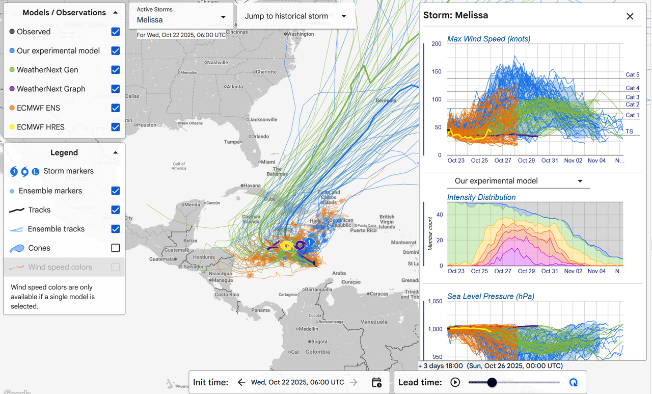
Weather nerds...
Just found this tool // website:
LINK to deepmind weather lab
Fascinating insight into various model data sets
Just found this tool // website:
LINK to deepmind weather lab
Fascinating insight into various model data sets
Posted on 10/22/25 at 8:24 pm to Allthatfades
That's the post of an a-hole. What a sensationalistic bitch.
This post was edited on 10/22/25 at 8:25 pm
Posted on 10/22/25 at 8:39 pm to Duke
quote:
That WSW turn.
Hurricane models are pinging on elite intensity potential. Which, given the depth and warmth of the water and a nice anticyclone over the top, makes sense.
Plus east coast has to watch closer with it getting farther west.
I posted earlier that this had high-end potential; it could make a run at Wilma and Gilbert. There really isn't anything in the modeled setup that would prevent it from busting the all-time records. It will come down to inner core dynamics and how long it can hold on before an ERC.
Posted on 10/22/25 at 8:44 pm to rds dc
quote:
posted earlier that this had high-end potential; it could make a run at Wilma and Gilbert. There really isn't anything in the modeled setup that would prevent it from busting the all-time records. It will come down to inner core dynamics and how long it can hold on before an ERC.
Funny how nature eventually finds a way to transfer insane heat away from an area

 Page 2 of 36

Popular
Back to top