- My Forums
- Tiger Rant
- LSU Recruiting
- SEC Rant
- Saints Talk
- Pelicans Talk
- More Sports Board
- Fantasy Sports
- Golf Board
- Soccer Board
- O-T Lounge
- Tech Board
- Home/Garden Board
- Outdoor Board
- Health/Fitness Board
- Movie/TV Board
- Book Board
- Music Board
- Political Talk
- Money Talk
- Fark Board
- Gaming Board
- Travel Board
- Food/Drink Board
- Ticket Exchange
- TD Help Board
Customize My Forums- View All Forums
- Show Left Links
- Topic Sort Options
- Trending Topics
- Recent Topics
- Active Topics
Started By
Message
re: May 4th Severe Weather Threat Thread (Flash Flood Emergency - Birmingham & Hoover, Ala.)
Posted on 5/4/21 at 3:39 pm to Bobby OG Johnson
Posted on 5/4/21 at 3:39 pm to Bobby OG Johnson
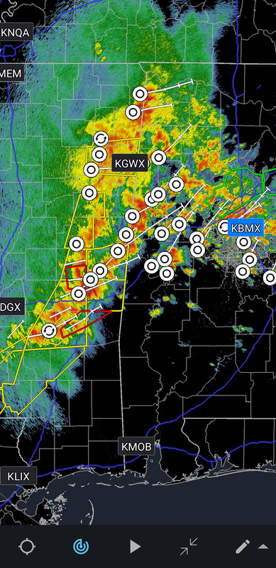
Gonna be tough telling wind from tornado damage with this line.
 0
0

Posted on 5/4/21 at 3:40 pm to LegendInMyMind
quote:
Are any of the storm chasers streaming?
I hope not in that mess.
Not that I would do it but isn't this type of weather what these guys and gals love? I mean you can't chase storms on a bluebird day.
Posted on 5/4/21 at 3:43 pm to Boudreaux35
That watch is farther south than I expected.
This post was edited on 5/4/21 at 3:44 pm
Posted on 5/4/21 at 3:47 pm to GEAUXmedic
That's a whole lot of storm tracks.
Posted on 5/4/21 at 3:49 pm to Boudreaux35
quote:
Not that I would do it but isn't this type of weather what these guys and gals love? I mean you can't chase storms on a bluebird day.
Not really. There's no "chasing" a QLCS with high winds like this. It would just be "pick a random spot, let the line bowl you over, drive back through it, pick another spot, let the line bowl you over".
There aren't many great looking discreet cells forming in clear air for them to track and watch develop. It would be primarily chase just for the sake of the chase.
This post was edited on 5/4/21 at 3:52 pm
Posted on 5/4/21 at 3:55 pm to Boudreaux35
quote:
Not that I would do it but isn't this type of weather what these guys and gals love? I mean you can't chase storms on a bluebird day.
Chasing rain wrapped tornados in the trees, in the midst of flash flood potential rains and a severe wind event on-going with the line...
Not what I'd call a good day of chasing.
Posted on 5/4/21 at 4:03 pm to Duke
Over near Airline and Pecue. The rain is coming down in two different directions. Never seen that before. The rain is coming in crossing paths
Posted on 5/4/21 at 4:05 pm to TulaneUVA
quote:
Over near Airline and Pecue. The rain is coming down in two different directions. Never seen that before. The rain is coming in crossing paths
Forrest, is that you?
Posted on 5/4/21 at 4:08 pm to LegendInMyMind
pretty serious flooding in Bham - they are considering a Flash Flood emergency
Posted on 5/4/21 at 4:10 pm to Thracken13
This shite has been training on that area for a while.
Posted on 5/4/21 at 4:16 pm to Thracken13
quote:
pretty serious flooding in Bham - they are considering a Flash Flood emergency
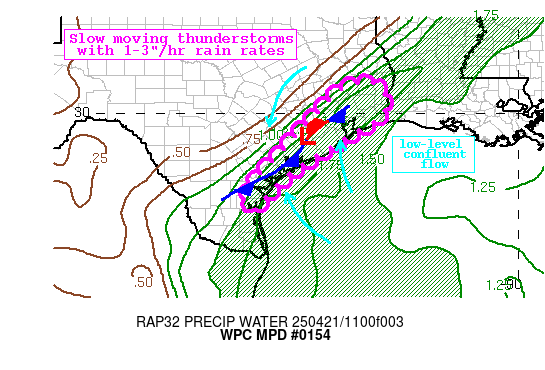
Quick overview from the WPC to show the factors coming together. There's a boundary (the dotted W to E running line) that all that southerly flow is lifting up over and raining out over Birmingham. Smaller scale feature causing a lot of trouble for Birmingham.
Unfortunately, the QLCS is yet to even roar through.
Posted on 5/4/21 at 4:16 pm to LegendInMyMind
yeah - makes me happy my apartment is on the top of a hill out 280 - no flooding here

Posted on 5/4/21 at 4:18 pm to TulaneUVA
quote:
Over near Airline and Pecue. The rain is coming down in two different directions.
I was just over there around lunch time.

If the storm tracks are correct, a lot of this will go North of Baton Rouge
This post was edited on 5/4/21 at 4:22 pm
Posted on 5/4/21 at 4:20 pm to Duke
I was just about to say that the Birmingham Metro area doesn't want to see any more storms form South of that one near Moundville out in front of the line. Just a mess.
Posted on 5/4/21 at 4:20 pm to Duke
yeah - i think we have the chance for borderline historic flooding when the main line gets here. the grounds here are very saturated - gonna be a lot of trees/lines down tonight
Posted on 5/4/21 at 4:26 pm to Thracken13
Northeast AL may end up in a similar situation as what is over Bham lifts their way, then the line moves through. They just had extensive Flash Flood Warnings expire, but may end up with more within the hour.
This post was edited on 5/4/21 at 4:26 pm

Posted on 5/4/21 at 4:27 pm to LegendInMyMind
Posted on 5/4/21 at 4:27 pm to Thracken13
quote:
yeah - i think we have the chance for borderline historic flooding when the main line gets here. the grounds here are very saturated - gonna be a lot of trees/lines down tonight
The one good thing is instability is going to be very limited over Birmingham tonight because of all the rain today and eventual lack of daytime heating. Surface based convection already appears to be shut down, the sounding from Birmingham tonight should confirm. That doesn't help with the frontal based rain though. That's not going to get cleared out until the line moves through.
The pine belt in southern Mississippi looks primed to take a punch as the line progresses. Current obs show party cloudy skies with temps getting into the 80s and juicy 70+ dews. Shear isn't rocking that hard, but will have stronger winds from aloft to pull down the farther north toward I20 you go.
Northshore too has this high CAPE brewing, but a little cloudier and farther from the upper disturbance should make the severe impacts a little less widespread I'd think.
This post was edited on 5/4/21 at 4:28 pm
Posted on 5/4/21 at 4:29 pm to Duke
just got the EAS for Flash Flood Warning for where I am in Shelby County
Posted on 5/4/21 at 4:31 pm to Duke
quote:
Northshore too has this high CAPE brewing, but a little cloudier and farther from the upper disturbance should make the severe impacts a little less widespread I'd think.
We talking CAPE?
Two days running low CAPE saw storms go wild and High CAPE fizzled. I love it when some on WXTwitter post monster CAPE soundings or models only to see it do nothing. Mississippi said the other day, "We don't need no stinkin' CAPE!"

 Page 24 of 28

Popular
Back to top