- My Forums
- Tiger Rant
- LSU Recruiting
- SEC Rant
- Saints Talk
- Pelicans Talk
- More Sports Board
- Fantasy Sports
- Golf Board
- Soccer Board
- O-T Lounge
- Tech Board
- Home/Garden Board
- Outdoor Board
- Health/Fitness Board
- Movie/TV Board
- Book Board
- Music Board
- Political Talk
- Money Talk
- Fark Board
- Gaming Board
- Travel Board
- Food/Drink Board
- Ticket Exchange
- TD Help Board
Customize My Forums- View All Forums
- Show Left Links
- Topic Sort Options
- Trending Topics
- Recent Topics
- Active Topics
Started By
Message
re: May 4th Severe Weather Threat Thread (Flash Flood Emergency - Birmingham & Hoover, Ala.)
Posted on 5/4/21 at 4:33 pm to LegendInMyMind
Posted on 5/4/21 at 4:33 pm to LegendInMyMind
just proves - no matter how much you think you know, Mother Nature will give you the middle finger and show you something
 1
1

Posted on 5/4/21 at 4:35 pm to Thracken13
quote:
just proves - no matter how much you think you know, Mother Nature will give you the middle finger and show you something
Twitter has a bad habit of never looking for failure modes. They get tunnel vision on a couple parameters and miss the bigger picture. The opposite is also true. Many of them lack any nuance and just get carried away.
Posted on 5/4/21 at 4:39 pm to LegendInMyMind
quote:
We talking CAPE?
Why not when there's an obvious lifting mechanism?
quote:
Two days running low CAPE saw storms go wild and High CAPE fizzled. I love it when some on WXTwitter post monster CAPE soundings or models only to see it do nothing. Mississippi said the other day, "We don't need no stinkin' CAPE!"
Just thinking on all the open warm sector busts over the years...

Posted on 5/4/21 at 4:43 pm to Thracken13
The line does not seem as bad as it moves through west Alabama, particularly the northern part of the line.
Posted on 5/4/21 at 4:46 pm to Roll Tide Ravens
quote:
The line does not seem as bad as it moves through west Alabama, particularly the northern part of the line.
All the rain ------> stable air. Go back to that WPC image I posted on that last page, basically north of the W to E boundary will be instability limited.
Posted on 5/4/21 at 4:48 pm to Duke
quote:
All the rain ------> stable air. Go back to that WPC image I posted on that last page, basically north of the W to E boundary will be instability limited
Yeah, and the earlier storms really worked the atmosphere from Birmingham north. Where I’m at north of Birmingham, my temp and dew point dropped into the lower 60s after those storms. It came back up during the lull, but the atmosphere clearly didn’t recover enough.
Posted on 5/4/21 at 5:03 pm to Roll Tide Ravens
quote:
Yeah, and the earlier storms really worked the atmosphere from Birmingham north. Where I’m at north of Birmingham, my temp and dew point dropped into the lower 60s after those storms. It came back up during the lull, but the atmosphere clearly didn’t recover enough.
It doesn't look like it can. The high energy air is getting lifted over y'all vs being able to advect in at the surface and reload quickly.
In weather oddities news, I'm watching a flurry and it's 50 degrees outside. I've seen wet bulbing, but this is a little ridiculous. It's evaporating basically on contact with the surface with this 40something% RH.
Posted on 5/4/21 at 5:08 pm to Roll Tide Ravens
Southern half of the line has its act together.
Posted on 5/4/21 at 5:12 pm to Roll Tide Ravens
Sounds like the NWS in Birmingham is on the verge of issuing a flash flood emergency for the Birmingham metro area.
Posted on 5/4/21 at 5:18 pm to Roll Tide Ravens
NWS Birmingham has issued a PDS Flash Flood Emergency for the Birmingham metro.
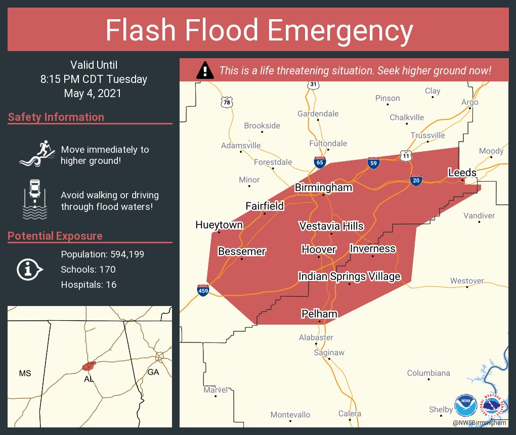
This post was edited on 5/4/21 at 5:21 pm
Posted on 5/4/21 at 5:23 pm to Roll Tide Ravens
quote:
@NWSBirmingham
This Flash Flood Warning has been upgraded to Considerable! This is a LIFE-THREATENING SITUATION!! Please DO NOT drive into flood waters! #alwx
Posted on 5/4/21 at 5:29 pm to Roll Tide Ravens
quote:
Yeah, and the earlier storms really worked the atmosphere from Birmingham north. Where I’m at north of Birmingham, my temp and dew point dropped into the lower 60s after those storms. It came back up during the lull, but the atmosphere clearly didn’t recover enough.
Last night was the first evening/night we've had in North AL where it felt like storms. This morning, after the first round, it was entirely different. It became evident with the wording from NWSHuntsville and them dropping the Tornado watch way early.
Posted on 5/4/21 at 5:30 pm to Roll Tide Ravens
quote:
Southern half of the line has its act together.
More lightning than I expected farther North. It just ran me back in the house off the porch.
Posted on 5/4/21 at 5:30 pm to LegendInMyMind
And looks like we have a wake low on the backside of the line. Winds really picking up behind the line in Tuscaloosa.
Posted on 5/4/21 at 5:32 pm to LegendInMyMind
Edit: knew I wouldn’t beat Bobby to it.
This post was edited on 5/4/21 at 5:33 pm
Posted on 5/4/21 at 5:33 pm to Duke
quote:
In weather oddities news, I'm watching a flurry and it's 50 degrees outside. I've seen wet bulbing, but this is a little ridiculous. It's evaporating basically on contact with the surface with this 40something% RH.
Mark Studduth showed their live cam in CO on his video yesterday, and it had some pretty good snow on the ground.
Posted on 5/4/21 at 5:33 pm to LegendInMyMind
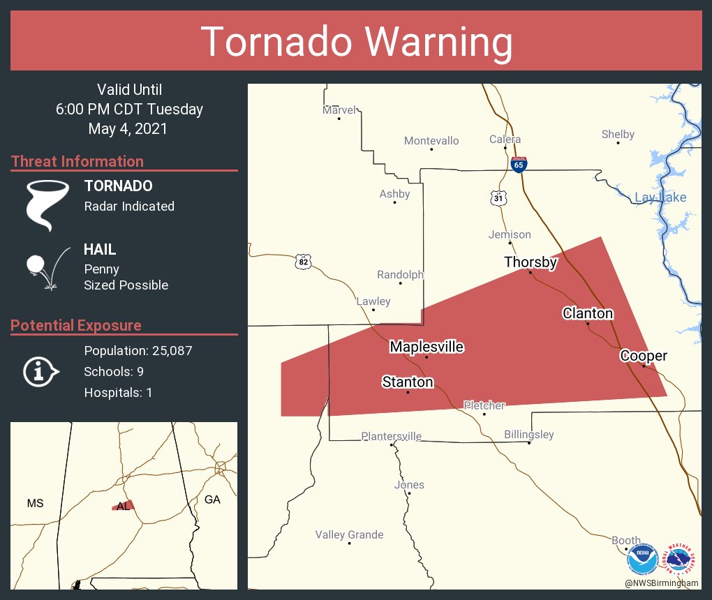
Confirmed tornado in Perry County, AL, moving into Chilton County.
Posted on 5/4/21 at 5:34 pm to LegendInMyMind
quote:
More lightning than I expected farther North. It just ran me back in the house off the porch.
Still getting convection, just elevated.
I miss thunderstorms.

 Page 25 of 28

Popular
Back to top