- My Forums
- Tiger Rant
- LSU Recruiting
- SEC Rant
- Saints Talk
- Pelicans Talk
- More Sports Board
- Fantasy Sports
- Golf Board
- Soccer Board
- O-T Lounge
- Tech Board
- Home/Garden Board
- Outdoor Board
- Health/Fitness Board
- Movie/TV Board
- Book Board
- Music Board
- Political Talk
- Money Talk
- Fark Board
- Gaming Board
- Travel Board
- Food/Drink Board
- Ticket Exchange
- TD Help Board
Customize My Forums- View All Forums
- Show Left Links
- Topic Sort Options
- Trending Topics
- Recent Topics
- Active Topics
Started By
Message
 1
1

Posted on 10/30/19 at 12:38 pm to 777Tiger
quote:
nd if it was cane harvesting season you were just fuccked
Still the case if you have to drive down to Thibodaux or Houma.
I remember driving up to Marxville one time to visit a girl I was seeing and getting stuck behind cane trucks for what seemed like an eternity. It’s a different world up there along La-1.
Posted on 10/30/19 at 12:39 pm to jlovel7
I used to get on the interstate 10 at Airline Hwy towards New Orleans when it was dirt and we would hunt ducks along it. Lots of good pass shooting.
Siegan Lane was gravel.
Siegan Lane was gravel.
Posted on 10/30/19 at 12:43 pm to jlovel7
3+ hours to travel between Laffy and Lake Chuck. If you traveling between Lake Chuck and Baton Rouge, it was Hwy 190 via Longville and Hwy 171 about 6 hours to get to an LSU game from Lake Chuck
Posted on 10/30/19 at 12:44 pm to The Boat
quote:
You had to get off I-49 and drive through Alexandria all the way up until 1996.
Funny you say that. My daughter played a softball tournament in Alex this past weekend. I haven't gotten off on 71 right there and gone around that traffic circle since 1991 on our way to the state cross country meet in Natchitoches.
You ain't lying. There was a frickin GAP in 49 right there at Alexandria!
This post was edited on 10/30/19 at 12:44 pm
Posted on 10/30/19 at 12:46 pm to Junky
quote:
The ponchartrain expressway follows the railway, which has been there for years.
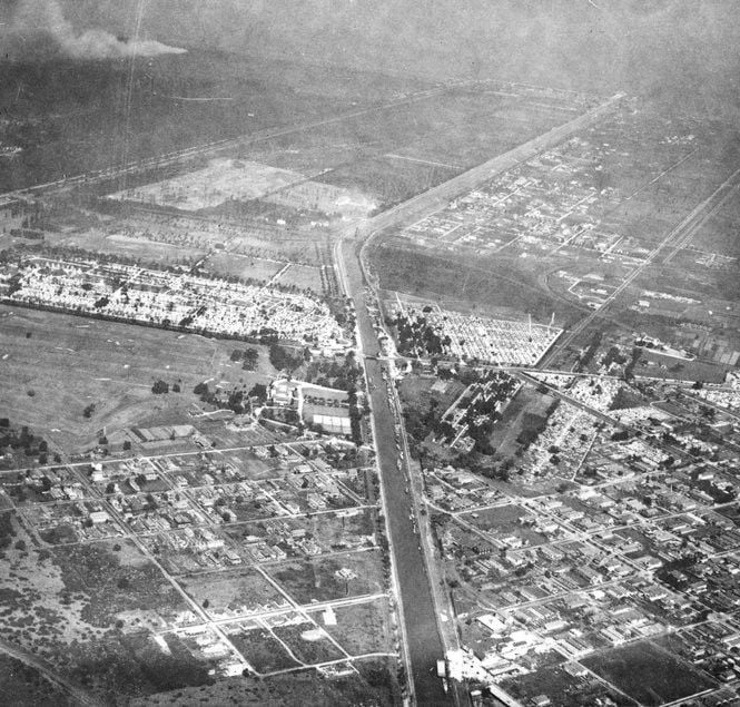
The Pontchartrain Expressway was once the New Basin Canal... You can see the Metairie and Greenwood cemeteries in the middle of the pic...
This post was edited on 10/30/19 at 12:54 pm

Posted on 10/30/19 at 12:46 pm to mikelbr
I love that they raised the speed limit through Alex recently. It was brutal having to drop from 75 to 60 for those 10 or so miles on I-49.
Posted on 10/30/19 at 12:46 pm to jlovel7
quote:
What was louisiana like before the interstate?
Litter free.
Posted on 10/30/19 at 12:48 pm to mikelbr
quote:
I haven't gotten off on 71 right there and gone around that traffic circle
used to like that because of the F-104 on a stick in that circle
Posted on 10/30/19 at 12:49 pm to VolsOut4Harambe
quote:
Not just in LA but everywhere, railroads played a much larger part in passenger transportation.
They were passe by 1950 for passenger travel. Since almost everyone had no more than one car per family, rail was used to travel if dad had to use it for work. 1955 1957 traveled on SP from Beaumont to Laffy with mom to visit her ailing mother and that was the only time I have ever been on a train, other than kiddy trains when visiting a zoo.
Posted on 10/30/19 at 12:50 pm to jlovel7
Better than it is now
Posted on 10/30/19 at 12:51 pm to CitizenK
quote:
other than kiddy trains when visiting a zoo.
those are trains too, baw!
Posted on 10/30/19 at 12:51 pm to Martini
quote:
I used to get on the interstate 10 at Airline Hwy towards New Orleans when it was dirt and we would hunt ducks along it. Lots of good pass shooting.
Siegan Lane was gravel.
That's when my parents bought in the first filing of Village St George.
A fun rabbit hole to take during a slow day at work is looking at older road maps next to google maps and tracking how you would have gone from Baton Rouge to New orleans in 1925.
The southern terminus of the Jefferson Highway was in New Orleans, Louisiana at the intersection of St. Charles Avenue and Common Street.[1] It is marked by a six-foot tall Georgia granite obelisk donated by the New Orleans chapter of the Daughters of the American Revolution. The obelisk was installed on April 15, 1918,[2] and it was formally dedicated the following January.[3]
The original route (finalized in December 1916)[4] on today's roads is as follows:
Louisiana
New Orleans to Kenner:
From the southern terminus at Common Street, the Jefferson Highway followed St. Charles Avenue, Canal Street, City Park Avenue, and Metairie Road into Jefferson Parish.
Leaving New Orleans, the Jefferson Highway followed Metairie Road, Shrewsbury Road, and Jefferson Highway to Kenner. This route is covered by LA 611-9, LA 3261, LA 611-3, US 90, and LA 48. (The section of road that is called "Jefferson Highway" between Shrewsbury Road and the New Orleans city limits at South Claiborne Avenue was not part of the original route, as it did not exist until 1928.)[5]
Kenner to Geismar:
From Kenner to Geismar, the Jefferson Highway followed alongside the east bank levee of the Mississippi River which, due to various sections of levee being relocated during the 1920s and 1930s, is often a significant distance removed from the modern River Road. Also, a two-mile section between Norco and Montz was eliminated in 1935 when the parallel U.S. 61 Bonnet Carré Spillway Bridge carrying Airline Highway across the Bonnet Carré Spillway was opened. However, the route is approximated by LA 48 to Norco, River Road to Montz, LA 628 to LaPlace, LA 44 to Burnside, LA 942 to Darrow, and LA 75 to Geismar. (Portions of the River Road at Reserve and Gramercy are still known as Jefferson Highway.)
Geismar to Baton Rouge:
From Geismar to Baton Rouge, the route followed LA 73 and is still known as (Old) Jefferson Highway.
The original routing through downtown Baton Rouge followed Claycut Road, LA 427 (South Acadian Thruway), LA 73 (Government Street), 19th Street, and North Street to the former Mississippi River ferry landing to Port Allen.
Jeffseron Highway Wiki
Gmaps to the southern end of Jefferson Hwy. Have you ever seen this monument?
This post was edited on 10/30/19 at 12:55 pm
Posted on 10/30/19 at 12:52 pm to kingbob
quote:
Still the case if you have to drive down to Thibodaux or Houma.
Back in the day, it was cane carts pulled by tractors. There were way more and much slower.

Posted on 10/30/19 at 12:52 pm to 777Tiger
Still there man. We like planes on sticks here in Alex.
Got more of em on the airbase
Got more of em on the airbase
Posted on 10/30/19 at 12:53 pm to tigerfoot
quote:
Got more of em on the airbase
used to be a happening base before all of the consolidation started

Posted on 10/30/19 at 12:54 pm to Shexter
quote:
quote:
SHV-BTR was a nightmare, could take 5-6 hours some times
I still like to take HWY 71 to get to Shreveport. I find it a great kick back drive with Lea's Pies a required stopping place.
The problem was the Alexandria to Shreveport part of the drive. SHV was a 3-hour drive from Alexandria on Hwy. 1, with the Alex to BR part of the drive clocking in at about 2 hours via 71 to 190.
Posted on 10/30/19 at 12:54 pm to Y.A. Tittle
quote:
Lea's was still overrated then, though. Perfect halfway spot.
Never terrible by any means, but nothing special. Logistics made Lea’s more money than their food.
Posted on 10/30/19 at 12:56 pm to jlovel7
quote:that was actually a man dug canal that went to the lake. Ever heard of the Carondolete and New Basin canals.?
Were things like the Ponchartrain expressway that cuts through downtown new orleans still there or was that not added until the interstate?

Posted on 10/30/19 at 12:57 pm to GeauxGutsy
Their pies were money. I actually still like them, but they are not quite as good as they used to be.
The rest of their food has always been pretty much just an excuse to get a slice of pie, though. I liked it for what it was.
The rest of their food has always been pretty much just an excuse to get a slice of pie, though. I liked it for what it was.

 Page 2 of 5

Popular
Back to top