- My Forums
- Tiger Rant
- LSU Recruiting
- SEC Rant
- Saints Talk
- Pelicans Talk
- More Sports Board
- Fantasy Sports
- Golf Board
- Soccer Board
- O-T Lounge
- Tech Board
- Home/Garden Board
- Outdoor Board
- Health/Fitness Board
- Movie/TV Board
- Book Board
- Music Board
- Political Talk
- Money Talk
- Fark Board
- Gaming Board
- Travel Board
- Food/Drink Board
- Ticket Exchange
- TD Help Board
Customize My Forums- View All Forums
- Show Left Links
- Topic Sort Options
- Trending Topics
- Recent Topics
- Active Topics
Started By
Message


 2
2

Posted on 3/9/16 at 2:14 pm to lsugolfredman
So I'm supposed to get 12" of rain and it isn't even raining here?

Posted on 3/9/16 at 2:15 pm to Hammertime
you know there is such a thing as tomorrow and the next day, right?
and Shreveport got 10" from like 3pm to midnight yesterday
so yeah...its possible
and Shreveport got 10" from like 3pm to midnight yesterday
so yeah...its possible
Posted on 3/9/16 at 2:16 pm to Clyde Tipton
with the way people talk about Johnny's on here I am surprised the entire community wasn't out there sand bagging
Posted on 3/9/16 at 2:17 pm to Salmon

Posted on 3/9/16 at 2:17 pm to rds dc
quote:
quote:
How the frick does the NWS miss this forecast by 200 miles? All this rain we were supposed to get in LC ended up in Shreveport. I could understand if it were an hour away or whatnot, but 200 miles?
This is one of NWS's all time busts events here. Thays an understatement.
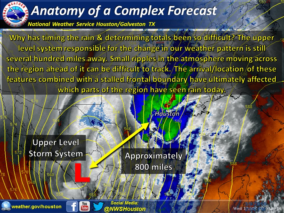
This has been a very hard system to forecast. The models have really struggled with it and there aren't many analogs for such a highly unusual setup.
Deep tropical moisture is streaming north out of the Gulf resulting in record PWAT across Texas, Louisiana and Arkansas. So one of the main ingredients is in place for extreme rainfall but the triggers have been very hard to get a handle on. Numerous waves of energy have been rotating around the base of the system and kicking out across Texas. Each of these waves of energy sets off rounds of thunderstorms. Forecasting convective evolution is still extremely hard and that is making it hard to nail down who gets the most rain and when.
Trends this morning certainly point to SE Texas and SW Louisiana getting in on the action today
Here is a graphic from NWS Houston touching on why this has been so tricky
Posted on 3/9/16 at 2:32 pm to Salmon
Caddo back under Flash Flood warning.

Posted on 3/9/16 at 2:40 pm to Clyde Tipton
is that johnnys on barksdale?
Posted on 3/9/16 at 2:43 pm to Polar Pop
It just said Bossier.
Posted on 3/9/16 at 2:44 pm to Clyde Tipton
Looks like the one in front of Krogers on Barksdale. That whole shady grove area floods like a bitch.
Posted on 3/9/16 at 2:46 pm to Polar Pop

Shreveport getting the shaft
Posted on 3/9/16 at 2:48 pm to arn
This reminds me of the 2009 levee break in Dogwood.
Posted on 3/9/16 at 2:54 pm to Polar Pop
quote:
Update, 1:20 p.m.: The latest forecast from the National Weather Service increases to amount of rain expected over the next three days in south Louisiana. The forecast now calls for around 10 inches in the New Orleans area and 4-5 inches in the Baton Rouge area.
Posted on 3/9/16 at 3:01 pm to spslayto
Just saw I-49 now has water issues south of shreveport. I-20 has the two spots at least between bossier and ruston closed. Saw a couple of y'all post about traveling through here today/tom.
Edit: sherif says highway 80 also closed near bossier so there isn't an open route through that area. Maybe highway 2 is open further north.
Edit: sherif says highway 80 also closed near bossier so there isn't an open route through that area. Maybe highway 2 is open further north.
This post was edited on 3/9/16 at 3:09 pm
Posted on 3/9/16 at 3:02 pm to Topwater Trout
quote:
with the way people talk about Johnny's on here I am surprised the entire community wasn't out there sand bagging
Johnny's? No. Franks? Yes.
This post was edited on 3/9/16 at 3:04 pm
Posted on 3/9/16 at 3:03 pm to Polar Pop
quote:
Looks like the one in front of Krogers on Barksdale. That whole shady grove area floods like a bitch.
Old parkway high school is being used as a shelter for evacuees
Posted on 3/9/16 at 3:04 pm to spslayto
quote:
10 inches in the New Orleans area and 4-5 inches in the Baton Rouge area.
Pretty safe bet that, BR posters will lambast the NWS for not getting as much rain as NOLA.
Posted on 3/9/16 at 3:08 pm to Polar Pop
quote:
This reminds me of the 2009 levee break in Dogwood.
This reminds me of 1991.
Posted on 3/9/16 at 3:09 pm to Bistineaubengal
I was still shitting my pants in 91 but I vaugely remember my mom rolling through floodwaters in the Accord to get me from daycare, my dad was overseas.
Posted on 3/9/16 at 3:11 pm to Bistineaubengal
quote:
This reminds me of 1991.
I was in middle school. My dad ran out of gas near ockley/fern. Had to walk, well wade, through ankle deep water.
First and last time he ran out of gas.

 Page 9 of 102

Popular
Back to top