- My Forums
- Tiger Rant
- LSU Recruiting
- SEC Rant
- Saints Talk
- Pelicans Talk
- More Sports Board
- Fantasy Sports
- Golf Board
- Soccer Board
- O-T Lounge
- Tech Board
- Home/Garden Board
- Outdoor Board
- Health/Fitness Board
- Movie/TV Board
- Book Board
- Music Board
- Political Talk
- Money Talk
- Fark Board
- Gaming Board
- Travel Board
- Food/Drink Board
- Ticket Exchange
- TD Help Board
Customize My Forums- View All Forums
- Show Left Links
- Topic Sort Options
- Trending Topics
- Recent Topics
- Active Topics
Started By
Message
First trip to rigs
Posted on 4/26/26 at 7:31 am
Posted on 4/26/26 at 7:31 am
Will be in grand isle for Memorial Day weekend. Fishing from SH BX25. Intend to run out to the rigs for snapper. Fished the bay a lot, have never run out to the rigs. At the risk of asking any fisherman for his fav spot, where would you go in a BX25 to have a decent shot at red snapper? Those rigs you can see from the beach, what is caught around them? Also, how would you get smart about locating rigs near GI on a map or with gps coordinates?
 11
11

Posted on 4/26/26 at 8:25 am to MAEFIELD
Whatever rig has a parade of boats next to it.
Just kidding
I’m mad because I won’t be there.
Just kidding
I’m mad because I won’t be there.
Posted on 4/26/26 at 8:54 am to MAEFIELD
I would hit the artificial reefs in the south timbalier 130 blocks. If you have the fuel a run to ship shoal may produce larger fish
Posted on 4/26/26 at 8:54 am to MAEFIELD
quote:
Those rigs you can see from the beach, what is caught around them?
Mangroves sometimes, mostly trash though. Mostly sharks. The close ones are only in 30 or 40 feet of water and the good red snapper fishing usually starts around 100 feet just because theres so much pressure closer in.
quote:
how would you get smart about locating rigs near GI on a map or with gps coordinates?
Rig locations are public information. Theres rig maps on the internet. Most GPS map cards will have them marked already. You're never out of sight of at least a half dozen of them until you get more than 50 miles out. That weekend itll be a real boat parade out there. If youre going to tie up to the rig and have never done that before, study up on how to safely do that more than where to fish. People's snapper holes are their most sacred secrets, so dont expect any hot tips. Just learn how to tie up safely and have fun.
Posted on 4/26/26 at 9:40 am to MAEFIELD
I would suggest downloading an app such as Navionics, Garmin boating, or whatever that has detailed offshore info, topography, relief shading and such would be helpful.
Put this on your phone and when you have time you can pinch and zoom and find a lot of stuff just looking at the maps. It will tell you water depth and distance. The rigs and wrecks will be marked. Find a distance you are comfortable with going and search within that range.
Hopefully you have a gps trolling motor on your sea hunt as that’s a hell of a lot easier than having to tie up to the rig.
Posted on 4/26/26 at 9:47 am to MAEFIELD
Here is an example from an app I use. This is the gulf out in front of the Fourchon rock barges. The image shows platforms, and wrecks, and very importantly it shows the depth. As I zoom in it shows more detail.
This is from Garmin boating and I pay an annual fee. Works as a great backup when offshore as you have to download the map area that you intend to use so it will work without a cell signal.
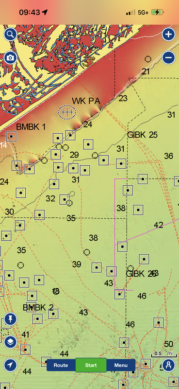
This is from Garmin boating and I pay an annual fee. Works as a great backup when offshore as you have to download the map area that you intend to use so it will work without a cell signal.
Posted on 4/26/26 at 10:55 am to MAEFIELD
ST 130s reef
28°41.445'N 90°9.757'W
Also you’ll be around other rigs to give other opportunities. If you’re new to offshore and want to go to South Timbaliar, I would suggest launching in Fourchon. If not, chances are you will shite your pants by accidentally cutting through LOOP.
28°41.445'N 90°9.757'W
Also you’ll be around other rigs to give other opportunities. If you’re new to offshore and want to go to South Timbaliar, I would suggest launching in Fourchon. If not, chances are you will shite your pants by accidentally cutting through LOOP.
Posted on 4/26/26 at 11:14 am to headedwest21
Thanks for the tips, very helpful. Given boat size, I’ll pick my days.
Posted on 4/26/26 at 11:56 am to MAEFIELD
Start at the rigs in the Grand Isle blocks- like 42….it will put you in about 130’ of water and you’re only 14 miles off from Caminada and 17 miles from Barataria Pass.
8oz sliding egg on your braid above the swivel, 80lb. flouro leader with a 10/0 circle hook. Drop and pull off the bottom, try a few different depths, get squid and cigar minnows or pogies- sometimes they are particular about what they eat.
It’s gonna all be about the seas, but by Memorial Day, we should have an abundance of good days.
ETA- heed Headwest’s advice- DO NOT cut through Loop. It’s on your chart. Pay attention. Otherwise, we will all laugh when they are calling you out: “Recreational Vessel heading 20 knots at “position” you are in a federally protected area, you must leave now- we have pictures of your vessel”
Good luck! I have fished all over the world and Grand Isle never gets old for me.
This post was edited on 4/26/26 at 12:00 pm
Posted on 4/26/26 at 12:20 pm to MAEFIELD
quote:
Thanks for the tips, very helpful. Given boat size, I’ll pick my days
In addition to the red snapper suggestions don’t sleep on targeting mangroves.
Bring some cat food or make some boiled spaghetti noodle chum and work up current of the platform. 10ft 30# floro and a red hook in a shrimp or pogie with no weight tossed into the feeding frenzy. With med weight spinning rod mangroves are blast and they eat just as good as RS.
Posted on 4/26/26 at 1:24 pm to headedwest21
quote:
chances are you will shite your pants by accidentally cutting through LOOP.
Been there done that with some buddies twenty years ago. That damn grey crew boat is fast fast

Posted on 4/26/26 at 9:10 pm to MAEFIELD
Thought I just read the new abbreviation for Rigolets.
Posted on 4/27/26 at 2:24 am to bayoudude
quote:
Been there done that with some buddies twenty years ago
What’s crazy is that before 9/11, we used to cut through all the time. Just had to holler at guy on radio that cutting through with bearing and he would tell you have a good day. After 9/11, you were getting chased. And if you ever been chased, you realize how quick that big boat can move.
Posted on 4/27/26 at 9:09 am to MAEFIELD
Early in the year there should be lots of snapper. Just try to get to 80 ft or deeper to get away from the nearshore trash. 100+ is better. I respectfully disagree with others about chum, no need to do that especially this early, the fish will be eager and plentiful. Use pogy or shrimp or mullet or cigar minnow or any meat on a hook with enough weight to get it down a bit in the current.
Posted on 4/27/26 at 11:18 am to MAEFIELD
Your best bet would be to go to LDWF website and get coordinates for the cutoffs in the GI, south Tim fields.
If not, GI 40s (15 miles from grand isle) should have decent snapper.
If not, GI 40s (15 miles from grand isle) should have decent snapper.
Posted on 4/27/26 at 11:43 am to MAEFIELD
If you don't already have them I found a guy through Facebook that sells a SD card with all the rigs/wellheads marked as waypoints for $50. I then went onto the LDWF website and pulled all the coordinates for all the reefs/cutoff rigs they have listed from ST all the way east to a bit past Venice and manually entered them into our unit. Even if you don't want to mess with the reefs/cutoffs I felt like for $50 it was a good value to have all the wellheads marked.
LINK
LINK
Posted on 4/27/26 at 3:19 pm to WizardSleeve
Biggest problem is that early snapper season always happens when the wind is very high

 Page 1 of 1


Popular
Back to top