- My Forums
- Tiger Rant
- LSU Recruiting
- SEC Rant
- Saints Talk
- Pelicans Talk
- More Sports Board
- Fantasy Sports
- Golf Board
- Soccer Board
- O-T Lounge
- Tech Board
- Home/Garden Board
- Outdoor Board
- Health/Fitness Board
- Movie/TV Board
- Book Board
- Music Board
- Political Talk
- Money Talk
- Fark Board
- Gaming Board
- Travel Board
- Food/Drink Board
- Ticket Exchange
- TD Help Board
Customize My Forums- View All Forums
- Show Left Links
- Topic Sort Options
- Trending Topics
- Recent Topics
- Active Topics
Started By
Message
 1
1

Posted on 8/29/23 at 5:55 pm to tokenBoiler
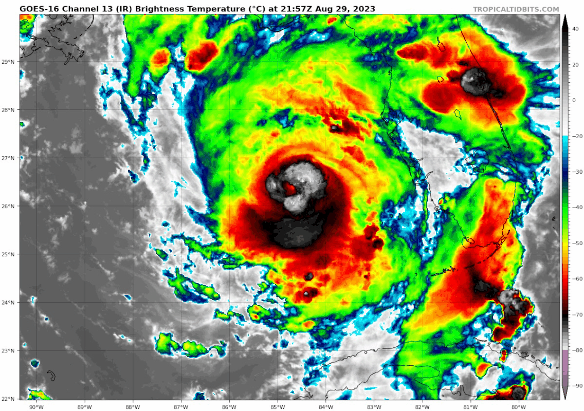
Surface pressure of 963 mb last pass. Think we see a Major Hurricane by next update?

Posted on 8/29/23 at 5:59 pm to joshnorris14
Still seeing lightning in the eye wall, which seems to be becoming more well defined and wrapping more completely around the eye.
Posted on 8/29/23 at 6:07 pm to joshnorris14
quote:
Surface pressure of 963 mb last pass
Vortex msg or extrap?

Posted on 8/29/23 at 6:10 pm to Roll Tide Ravens
quote:
Derrick Herndon
@DerrickHerndon2
Recon is reporting concentric eyewalls. This seems less like an ERC and more like a banding eye feature possibly due to some dry air entrainment seen earlier that has wrapped around the outer eyewall.


Posted on 8/29/23 at 6:12 pm to Bobby OG Johnson
quote:
Recon is reporting concentric eyewalls. T
Well that's a new term. Add it to the bingo card.
Posted on 8/29/23 at 6:15 pm to alphaandomega
I'd try the Rotary club in Crawfordville. Or one of the larger churches. Or the Wakulla County Sheriff's office. But I really don't have contacts there per se.
Posted on 8/29/23 at 6:15 pm to jfan244888
Looks like it makes a decent jump NE in this frame.
EDIT: NE. I’m dumb.
This post was edited on 8/29/23 at 6:18 pm

Posted on 8/29/23 at 6:17 pm to LPLGTiger
I dont see it
Still going due north of east
Still going due north of east
Posted on 8/29/23 at 6:19 pm to joshnorris14
quote:
Think we see a Major Hurricane by next update?
I don't think so. Has some work to do with wind to get there.
Posted on 8/29/23 at 6:24 pm to gladchiefisgone
quote:
I flew on P-3 Orion's in the Navy back in the 70's and early 80's....That plane was a workhorse and one of the toughest in the Navy fleet.
My BIL flew on the SIGINT version. He had a card in his wallet promising $20k in gold for his safe return if he was shot down.

Posted on 8/29/23 at 6:24 pm to Roll Tide Ravens
What's the significance of lightning in the eyewall?
Posted on 8/29/23 at 6:26 pm to deeprig9
quote:
What's the significance of lightning in the eyewall?
Deeper convection with storms building higher making them able to form ice crystals and thus produce lightning. Generally a sign of a strengthening storm.

Posted on 8/29/23 at 6:28 pm to LegendInMyMind
It’s a good thing she is moving forward at a high speed. Less time to get stronger over those super warm gulf waters.

Posted on 8/29/23 at 6:28 pm to rds dc
Pinellas and Hillsborough bros, are ya breathing a sigh of relief yet?
Posted on 8/29/23 at 6:28 pm to Bobby OG Johnson
quote:
Dr. Levi Cowan
@TropicalTidbits
The last 2 hours of aircraft reconnaissance observations show #Idalia moving slightly east of north, close to the latest NHC forecast track. East of north motion is what you want to see if you are in #Franklin, #Wakulla, #Jefferson, or #Leon counties, but not so great for #Taylor County and #Dixie County. Hurricanes wobble, so short-term motions like this don't guarantee anything. Expect massive storm surge in the Apalachee Bay area and points southeast no matter what.


Posted on 8/29/23 at 6:36 pm to Bobby OG Johnson

Posted on 8/29/23 at 6:38 pm to Bobby OG Johnson
Max wind on radar is ~105mph at ~17.5K feet. That's in the heaviest rain band on the SSE side. Not the end all, especially since we have planes in there. Just good to compare.
This post was edited on 8/29/23 at 6:40 pm
Posted on 8/29/23 at 6:38 pm to Bernie Bierman
quote:
Pinellas and Hillsborough bros, are ya breathing a sigh of relief yet?
The eye of Katrina missed NOLA. No sigh of relief until tomorrow.
Posted on 8/29/23 at 6:43 pm to VCeagle2013
quote:
Dixie County


 Page 103 of 139

Popular
Back to top