- My Forums
- Tiger Rant
- LSU Recruiting
- SEC Rant
- Saints Talk
- Pelicans Talk
- More Sports Board
- Fantasy Sports
- Golf Board
- Soccer Board
- O-T Lounge
- Tech Board
- Home/Garden Board
- Outdoor Board
- Health/Fitness Board
- Movie/TV Board
- Book Board
- Music Board
- Political Talk
- Money Talk
- Fark Board
- Gaming Board
- Travel Board
- Food/Drink Board
- Ticket Exchange
- TD Help Board
Customize My Forums- View All Forums
- Show Left Links
- Topic Sort Options
- Trending Topics
- Recent Topics
- Active Topics
Started By
Message
Severe weather threat tomorrow
Posted on 10/11/22 at 1:56 pm
Posted on 10/11/22 at 1:56 pm

quote:
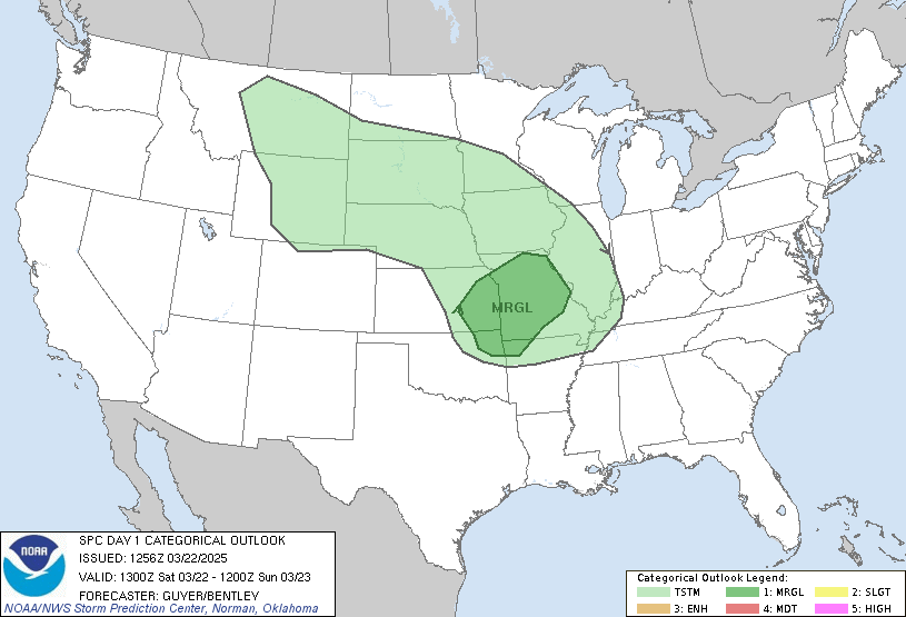
Synopsis... A large-scale upper trough will develop eastward from the Plains on Wednesday morning, becoming oriented from the Upper Midwest to the Southeast by Thursday morning. Enhanced southwesterly flow ahead of the trough will overspread much of the Midwest, and decreasing with southward extent into the southern U.S. At the surface, a cold front extending from WI southwestward into western OK/northwest TX will sweep eastward during the forecast period. By Thursday morning, the front is expected to extend from western NY/PA toward Middle TN, southwestward toward the TX coast. ...Middle TN into the OH Valley Vicinity... Stronger vertical shear will be in place across the region, closer to the core of the upper trough and within the stronger surface pressure gradient associated with a low over Ontario. South/southwesterly low-level flow will bring a narrow corridor of upper 50s and 60s F surface dewpoints northward ahead of the eastward-advancing cold front. Heating will be limited by cloud cover and possibly early day showers. However, cooling aloft will support modestly steep midlevel lapse rates, and MLCAPE of a few hundred J/kg will be possible amid 30+ kt effective shear magnitudes. Transient supercells and briefly organized clusters could produce isolated strong storms capable of hail and strong gusts. Low-level instability will be limited, but enlarged, favorably curved surface-3 km hodographs suggest a brief tornado also could occur. ...AR into western TN/northern MS Vicinity... Additional thunderstorms are expected to develop along the front during the afternoon across AR and shift east/southeast into western TN and northern MS. Some guidance suggest an increase in hail and strong gust potential will accompany these cells. Stronger heating is expected along this corridor ahead of the front, resulting in steeper low-level lapse rates, while cooling aloft associated with the main upper trough supports steepening mid-level lapse rates. Effective shear magnitudes around 25-35 kt and favorable hodographs suggest some rotating cells will be possible. A narrow corridor of relative greater severe potential may exist within this corridor and an upgrade to Slight risk may be needed in subsequent outlooks if forecast confidence increases.
May see an upgrade to Slight risk in ar, Tn, North Ms
This post was edited on 10/12/22 at 8:38 am
Posted on 10/11/22 at 1:59 pm to deltaland
"Marginal"??
Lame.
Sounds like a Southern Californian panicking over a quarter inch of rain.
Lame.
Sounds like a Southern Californian panicking over a quarter inch of rain.
Posted on 10/11/22 at 1:59 pm to deltaland
Gonna need at least yellow, delta, before a thread is warranted. At least.
Posted on 10/11/22 at 1:59 pm to deltaland
Congrats on getting to start a weather thread
Posted on 10/11/22 at 3:48 pm to deltaland
Cancel school for a cool front season
[ON]
OFF
[ON]
OFF
Posted on 10/11/22 at 3:49 pm to deltaland
It'd be nice to get some fricking rain in SELA
Posted on 10/11/22 at 3:51 pm to deltaland
Water falling from the sky? What sorcery is this?
Posted on 10/11/22 at 8:09 pm to deltaland
So nowadays, we call thunderstorm forecasts “slight, marginal or enhanced severe weather”.
And in the map above, about a third of the country will be under a “marginal severe weather alert”, which means “it’s gonna rain y’all”.
And in the map above, about a third of the country will be under a “marginal severe weather alert”, which means “it’s gonna rain y’all”.
Posted on 10/12/22 at 11:53 am to deltaland
Thread is shite. Looks to be dry as your gmaws pussy today
Popular
Back to top
 12
12


