- My Forums
- Tiger Rant
- LSU Recruiting
- SEC Rant
- Saints Talk
- Pelicans Talk
- More Sports Board
- Fantasy Sports
- Golf Board
- Soccer Board
- O-T Lounge
- Tech Board
- Home/Garden Board
- Outdoor Board
- Health/Fitness Board
- Movie/TV Board
- Book Board
- Music Board
- Political Talk
- Money Talk
- Fark Board
- Gaming Board
- Travel Board
- Food/Drink Board
- Ticket Exchange
- TD Help Board
Customize My Forums- View All Forums
- Show Left Links
- Topic Sort Options
- Trending Topics
- Recent Topics
- Active Topics
Started By
Message

Wednesday weather thread: MS, AL, LA, TN, Enhanced for MS, AL, TN
Posted on 12/27/21 at 6:54 am
Posted on 12/27/21 at 6:54 am

quote:
Severe thunderstorms are possible for portions of the Deep South into the southwestern Appalachians.
quote:
Most guidance suggests some convection may be ongoing at the beginning of the period near the Red River across northeast Texas. In that area, isentropic ascent will be increasing as the low-level jet strengthens in response to the ejecting mid-level shortwave trough. As these thunderstorms continue east-northeast, they will encounter an increasingly unstable airmass across southern Arkansas and northern Louisiana, where mid 60s dewpoints will be present by mid to late morning. Supercell wind profiles are expected across the entire warm sector with 50 to 65 knots of effective vertical shear. Therefore, this activity could be severe during the morning hours across portions of southern Arkansas and northern Louisiana. Regardless of the evolution of this early day storm activity, additional storm development is expected during the afternoon hours. Then, the influence of the weak southern stream mid-level shortwave trough overspreads the warm sector, and the surface low moves out of the Plains and into the Mid-Mississippi Valley.
quote:
These uncertainties also impact expected storm intensity due to the influence on the low-level wind field. Most guidance shows a broad 40 knot low-level jet with a peak around 50 kts eventually moving into eastern Tennessee Wednesday night. However, the weak surface low results in light surface winds across much of the warm sector. This would be a limiting factor to the tornado threat, and especially the significant tornado threat, which would be greater with a stronger surface low such as is depicted by the 00Z NAM. Given the uncertainties mentioned above, a slight risk seems justified at this time. However, if model guidance trends toward a stronger system or if more widespread warm sector convection appears likely, an enhanced risk may be needed in later outlooks.
At least for now, this system appears to be only minimal. Let's hope the stronger system does not develop.
This post was edited on 12/29/21 at 6:14 am
 20
20

Posted on 12/27/21 at 6:59 am to East Coast Band
1st page
Posted on 12/27/21 at 7:06 am to East Coast Band
Hoping this means we have a significant cool front coming through. It’s been as hot as Satan’s ballsack for December.
Posted on 12/27/21 at 7:11 am to East Coast Band
Does this mean winter is finally coming???
Oh and 1st page
Oh and 1st page

Posted on 12/27/21 at 7:13 am to East Coast Band
20's in North LA

Posted on 12/27/21 at 7:30 am to East Coast Band
Bad weather incoming....
1st page
1st page
Posted on 12/27/21 at 7:30 am to Strannix
For one day

Posted on 12/27/21 at 7:55 am to East Coast Band


Posted on 12/27/21 at 8:42 am to East Coast Band
The older I get, the more I hate seeing these threads.
Posted on 12/27/21 at 9:33 am to High C
I was told in another thread there would be a TD meetup at Mt Driskill only requirement is that you bring snow skis or a snowboard.
Posted on 12/27/21 at 11:12 am to Tigersonfire
quote:
Does this mean winter is finally coming???
We'll get like two days of Winter temps. Then it is back to the 60s and 70s.
This post was edited on 12/27/21 at 11:13 am
Posted on 12/27/21 at 11:13 am to East Coast Band
quote:
Let's hope the stronger system does not develop.
That one is concerning.
ETA: I just pulled a sounding for central LA on Saturday evening that had 79°/70°....in January.
This post was edited on 12/27/21 at 11:21 am
Posted on 12/27/21 at 12:20 pm to East Coast Band
Wednesday is an appetizer, this weekend will be the main event with the potential for a widespread severe outbreak due to a large mid level trough and yes, cold weather afterward.

Posted on 12/27/21 at 12:32 pm to deltaland
25-30 degree 24 hour temperature changes in bound the week of January 3rd

Posted on 12/27/21 at 12:36 pm to East Coast Band
That High Pressure Ridge over Florida can gf itself.
Posted on 12/27/21 at 8:49 pm to The Boat
Going to be interesting to see what the storms/showers across the area tomorrow do for the Wednesday storm development. We will probably have a few boundaries evident throughout the day Wednesday leftover from tomorrow's activity.
That will also help the dews go even higher, though they don't need much help. Temps in the mid 70s as far North as central AL with dews in the mid to upper 60s. It may as well be March. The NAM is showing plenty of cells firing across the warm sector. There will be decent CAPE and plenty of moisture.
Wednesday's potential is looking better than I expected.
Posted on 12/28/21 at 10:29 am to LegendInMyMind
quote:
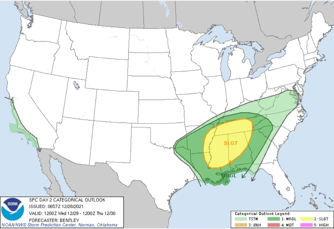
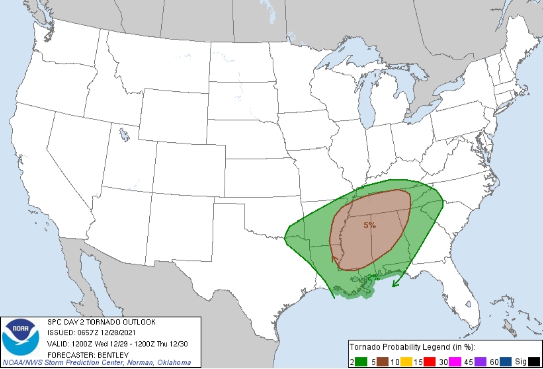
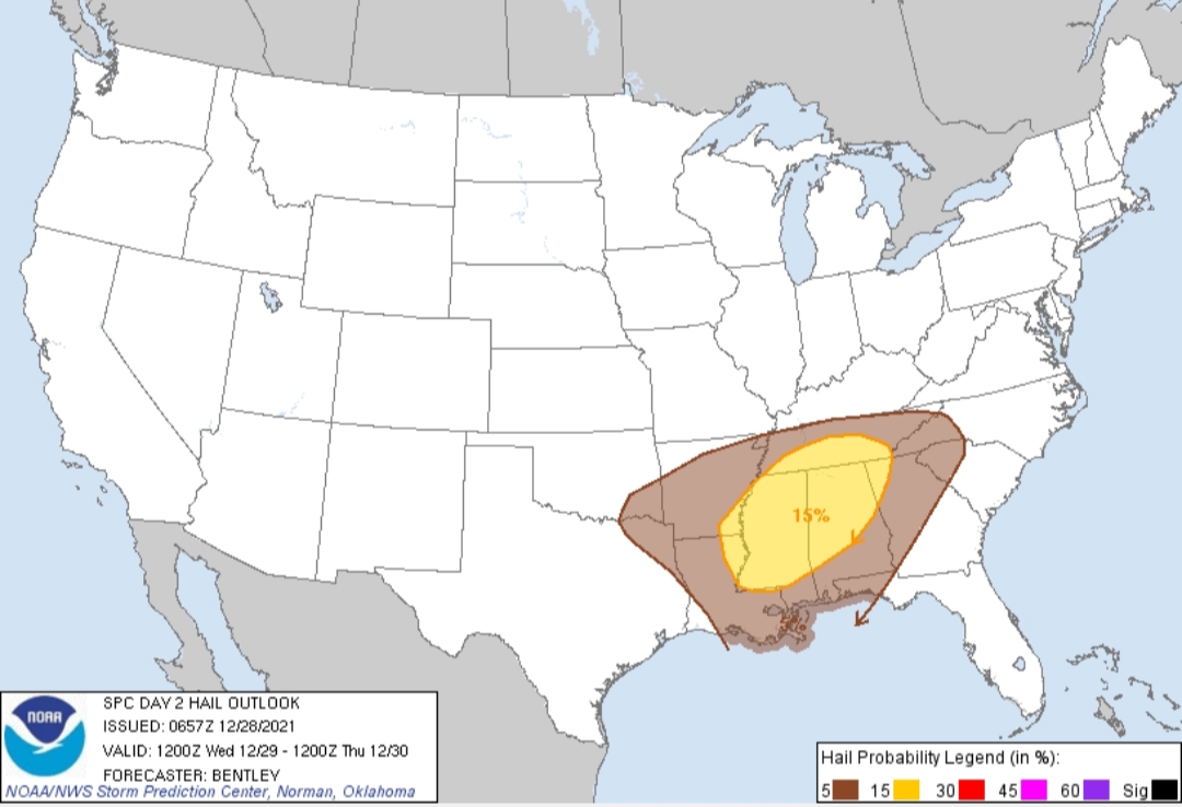
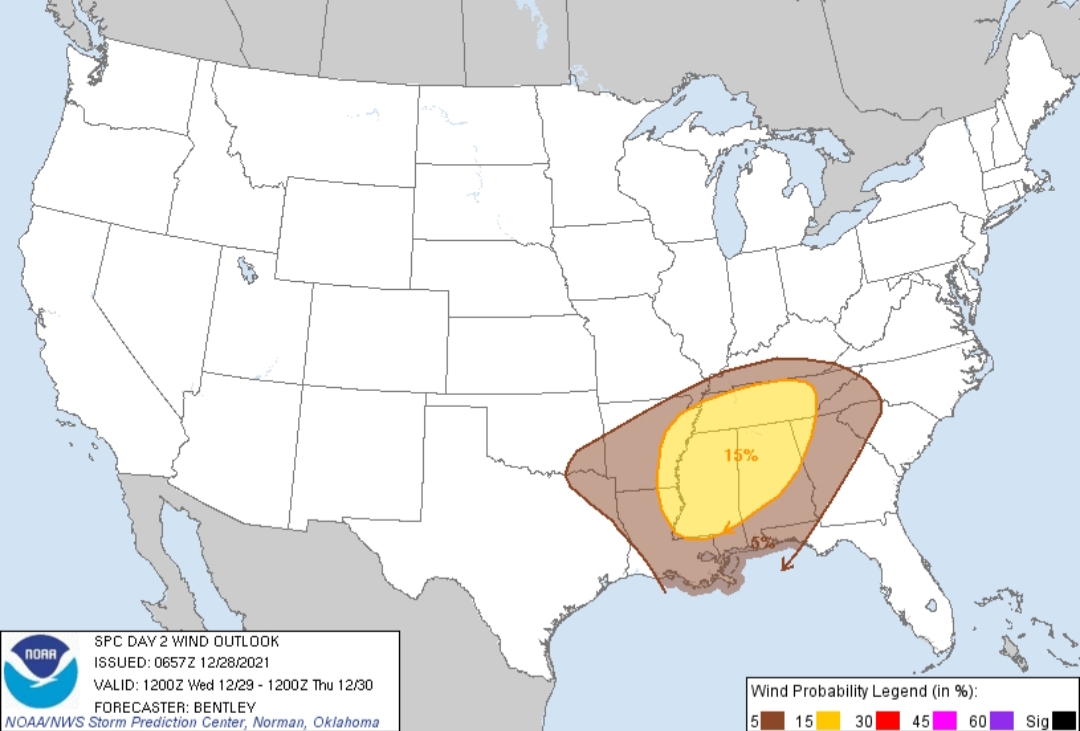
Day 2 Convective Outlook NWS Storm Prediction Center Norman OK 1257 AM CST Tue Dec 28 2021
Valid 291200Z - 301200Z
...THERE IS A SLIGHT RISK OF SEVERE THUNDERSTORMS FOR PORTIONS OF THE MID-SOUTH AND TENNESSEE VALLEY...
...SUMMARY... Severe thunderstorms are possible for portions of the Deep South into the Tennessee Valley. Large hail, damaging winds, and a few tornadoes will be possible.
...Synopsis... A mid-level shortwave trough can be seen off the Oregon coast early Tuesday morning. This shortwave will round the base of the large-scale trough to near the Southern High Plains by 12Z Wednesday and into the northern Great Lakes by Thursday night. This will overspread weak height falls across the warm sector during the day Wednesday. Meanwhile, a lee cyclone is expected to develop near the Oklahoma Panhandle Wednesday morning and move quickly eastward along the surface front through the day. Guidance has come into better agreement showing a closed surface low developing along the front, but there still remains some uncertainty in the exact location and strength of this surface low.
...Portions of the Mid-South and Tennessee Valley... A long-fetch Caribbean moisture feed will be in place across the Southeast on Wednesday morning with mid-60s dewpoints into southern Tennessee at 12Z. Low-level flow will strengthen in response to the developing surface low along the front Wednesday afternoon. This will advect higher theta-e air northward with mid 60s dewpoints into north central Tennessee and upper 60s dewpoints into portions of northern Mississippi and Alabama. Some breaks in the clouds are anticipated in this region as low-level cloud streaks advect northward across the warm sector, which may allow temperatures to warm into the mid to upper 70s. As a result, ample instability is anticipated across the warm sector, with MLCAPE in excess of 1500 J/kg possible as far north as Columbus, Mississippi.
Thunderstorms will likely be ongoing at the beginning of the period near the Red River in southeast Oklahoma/northeast Texas in response to increasing isentropic ascent as the low-level jet strengthens. This activity is expected to continue northeastward through the day and may eventually overspread the warm sector, and become surface based. The marginal and slight risk have been expanded northward to account for this possibility given the favorable severe parameter space across much of the warm sector Wednesday afternoon.
The primary severe weather threat will be focused on thunderstorms east of this activity in a region of broad, weak isentropic ascent where a confluence band could set up off the Gulf of Mexico. Expect storms to develop out of cloud streaks which will be streaming north through the morning. 00Z CAM guidance appears to be subdued in reflectivity and updraft helicity depiction. Forecast soundings in proximity of this convection would suggest more intense storm development than is currently shown. CAM guidance has had similar issues in past cool-season Southeast severe events, and therefore it could be a false depiction of storm intensity based on the environment. However, there are times when lackluster CAM reflection of storm intensity is hinting at a greater problem with forcing. This is at least somewhat of a concern given the mostly neutral height tendency across the region for much of the event.
Any storms which develop in this region will encounter favorable vertical shear for supercells with effective shear in excess of 50 knots. In addition, the weakly forced nature of the convection will likely favor a mostly discrete storm mode. These storms should have a tornado threat, given the strengthening low-level jet, with a broad region of 40 knots of southwesterly flow at 850mb depicted by most guidance. This will yield effective SRH around 250 m2/s2 which will be more than sufficient for a few tornadoes.
An upgrade to enhanced (10%/sig) was considered across northern Mississippi and northwest Alabama, but ultimately settled on an expansion of the slight risk for this outlook. If guidance continues to trend toward a stronger surface low, and if CAM guidance starts to show more intense storm development, an upgrade to enhanced may be necessary.
..Bentley.. 12/28/2021
CLICK TO GET WUUS02 PTSDY2 PRODUCT
NOTE: THE NEXT DAY 2 OUTLOOK IS SCHEDULED BY 1730Z
Posted on 12/28/21 at 11:38 am to East Coast Band
So, we get one day of winter temps and then back to muggy/humid mild summer weather. Cool, gfy.

Posted on 12/28/21 at 1:01 pm to Birdie225
Feels like Temps 20s for the southshore Monday morning, 60s on Tuesday. What the frick is happening 
Posted on 12/28/21 at 1:45 pm to geauxtigers87
quote:
Feels like Temps 20s for the southshore Monday morning, 60s on Tuesday. What the frick is happening
AOC is fricking with the thermostat.

 Page 1 of 7

Popular
Back to top