- My Forums
- Tiger Rant
- LSU Recruiting
- SEC Rant
- Saints Talk
- Pelicans Talk
- More Sports Board
- Fantasy Sports
- Golf Board
- Soccer Board
- O-T Lounge
- Tech Board
- Home/Garden Board
- Outdoor Board
- Health/Fitness Board
- Movie/TV Board
- Book Board
- Music Board
- Political Talk
- Money Talk
- Fark Board
- Gaming Board
- Travel Board
- Food/Drink Board
- Ticket Exchange
- TD Help Board
Customize My Forums- View All Forums
- Show Left Links
- Topic Sort Options
- Trending Topics
- Recent Topics
- Active Topics
Started By
Message
re: Zeta - The cleanup begins
Posted on 10/24/20 at 10:56 pm to lsufan4lifeMiles
Posted on 10/24/20 at 10:56 pm to lsufan4lifeMiles
That's right
 0
0


Posted on 10/24/20 at 11:09 pm to trussthetruzz
quote:
If this thing makes a beeline to the LA coast I vote he gets to come back early. His input is valuable
This idiot has some of you so fooled on here. I can throw up the same images he does and throw out some nonsense words behind it just as easily as he does. There are only a few people who you should listen to for advice on here.
shite, PJ should be listened to more than him. You just have to do the opposite of what PJ says, but he still knows more by knowing less.
Posted on 10/24/20 at 11:14 pm to oOoLsUtIgErSoOo
quote:
This idiot has some of you so fooled on here. I can throw up the same images he does and throw out some nonsense words behind it just as easily as he does.
Yikes, I would hope no one looks to him for decision making info. He just keeps the thread moving and keeps it from going stale in between RDS and Duke updates.
He had a tireless energy when it comes to these hurricane threads. That’s his “value”
Posted on 10/24/20 at 11:19 pm to Bobby OG Johnson
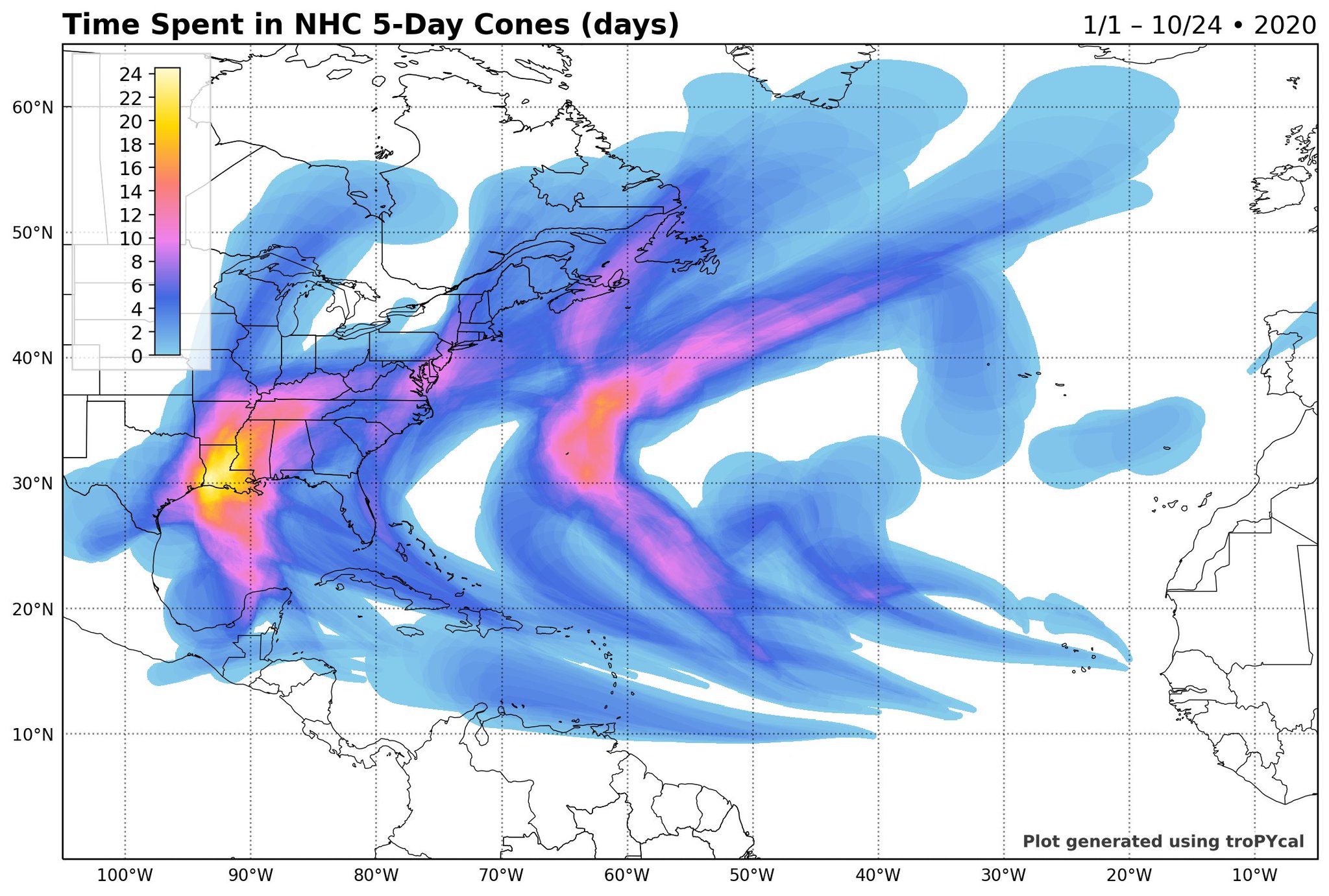
quote:
Louisiana has had a cumulative of THREE WEEKS in the cone this year!
Damn. I don't know why, but that chart drives that fact home.
Posted on 10/24/20 at 11:24 pm to oOoLsUtIgErSoOo
You have an unusual obsession with slackster. He might want to get a restraining order on you.
Posted on 10/24/20 at 11:26 pm to oOoLsUtIgErSoOo
quote:
shite, PJ should be listened to more than him. You just have to do the opposite of what PJ says, but he still knows more by knowing less.
Find the lie

Posted on 10/24/20 at 11:36 pm to lsufan4lifeMiles
quote:
Should I evacuate from Plaquemines Parish before it’s mandatory?
what’s your opinion on halftime traffic?

Posted on 10/24/20 at 11:37 pm to rds dc
Posted on 10/24/20 at 11:45 pm to Who_Dat_Tiger
Slacksterwould say “the cone is a margin of error of 5,000 miles in a 120 hour window, so anywhere from Mexico City to Tallahassee should be watching out. Let’s see how it plays out the next 5 days.”
Posted on 10/25/20 at 12:14 am to LegendInMyMind
Well since I'm nocternal now, guess it's as good a time as any to set the table with this one.
So as of 00z tonight:

Got a shortwave over SE Alabama/Georgia/FL panhandle. This feature is going to be moving out of the way tonight and tomorrow and a ridge is going to build in behind it from the west.
Additionally the start of the big upper trough that will bring a cold front through here next week and potentially some winter weather into places as far SE as the TX Panhandle and Oklahoma can be seen up in Canada and into Montana and Idaho. This feature will dive south over the next day and have a substantial trough over the mountain west.
In the following image: feature 1 is the big western storm system, feature 2 is the little shortwave exiting, and the arrow is out of the ridge forming over Texas and starting to build east (you know, where the arrow points).

So what's going to happen is that ridge builds east and ends up over Florida directing traffic WNW to NW by Tuesday (sound familiar bc it should). This will get the storm moving and into the Gulf of Mexico.

Note the 591 dm heights over Florida, there's the heart of our ridge. Clockwise flow around it, pushing everything on it's western side to the north. Then comes the tricky part...
The incoming western storm system will begin to break down the ridge as it approaches and end up providing a strong push to the NE for anything in the Gulf. The difficult detail is exactly when it pushes in to force the turn.

This is the main source of why the models are going to have a big spread on this early on. The details on timing matter and those aren't easy to get right exactly in the 5 day range.
Let's look at the Euro vs GFS to illustrate.
The 12z Euro from today:

Stronger ridge centered over Florida with 591 height line extending into the eastern gulf with a slower moving western system. This allows the storm to get farther west before turning NE.
The GFS at 00z tonight for the same point in time:

Western system faster, ridge farther east. Storm would end up farther east.
So there is a lot of uncertainty in the end game here as the models figure out exactly what's going to happen timing wise. The trend this year is for that SE ridge to be persistent and stronger, so I would discount the Euro just because it hasn't had a great year.
Just look at the GFS ensembles:

Quite a spread of possibilities. You'll also note the stronger members are to the east side. That's because the incoming system from the west is going to bring a lot of shear and dry air to the party. So a stronger system is only possible farther east just ahead of the big shear.
That's the basics on the big picture steering for this thing. Just going to be watching how the players evolve and that'll narrow the possible outcomes.
I'll make a post in a little bit concerning strength.
So as of 00z tonight:
Got a shortwave over SE Alabama/Georgia/FL panhandle. This feature is going to be moving out of the way tonight and tomorrow and a ridge is going to build in behind it from the west.
Additionally the start of the big upper trough that will bring a cold front through here next week and potentially some winter weather into places as far SE as the TX Panhandle and Oklahoma can be seen up in Canada and into Montana and Idaho. This feature will dive south over the next day and have a substantial trough over the mountain west.
In the following image: feature 1 is the big western storm system, feature 2 is the little shortwave exiting, and the arrow is out of the ridge forming over Texas and starting to build east (you know, where the arrow points).
So what's going to happen is that ridge builds east and ends up over Florida directing traffic WNW to NW by Tuesday (sound familiar bc it should). This will get the storm moving and into the Gulf of Mexico.
Note the 591 dm heights over Florida, there's the heart of our ridge. Clockwise flow around it, pushing everything on it's western side to the north. Then comes the tricky part...
The incoming western storm system will begin to break down the ridge as it approaches and end up providing a strong push to the NE for anything in the Gulf. The difficult detail is exactly when it pushes in to force the turn.
This is the main source of why the models are going to have a big spread on this early on. The details on timing matter and those aren't easy to get right exactly in the 5 day range.
Let's look at the Euro vs GFS to illustrate.
The 12z Euro from today:
Stronger ridge centered over Florida with 591 height line extending into the eastern gulf with a slower moving western system. This allows the storm to get farther west before turning NE.
The GFS at 00z tonight for the same point in time:
Western system faster, ridge farther east. Storm would end up farther east.
So there is a lot of uncertainty in the end game here as the models figure out exactly what's going to happen timing wise. The trend this year is for that SE ridge to be persistent and stronger, so I would discount the Euro just because it hasn't had a great year.
Just look at the GFS ensembles:
Quite a spread of possibilities. You'll also note the stronger members are to the east side. That's because the incoming system from the west is going to bring a lot of shear and dry air to the party. So a stronger system is only possible farther east just ahead of the big shear.
That's the basics on the big picture steering for this thing. Just going to be watching how the players evolve and that'll narrow the possible outcomes.
I'll make a post in a little bit concerning strength.
Posted on 10/25/20 at 12:34 am to oOoLsUtIgErSoOo
quote:
This idiot has some of you so fooled on here. I can throw up the same images he does and throw out some nonsense words behind it just as easily as he does. There are only a few people who you should listen to for advice on here.
I don't think anybody has him on the level of the weather experts on here but he has been engaged in these threads for long enough and paid attention that he's actually picked up enough to be a solid contributor. If nothing else, he can sometimes translate when Duke or rds veer too much into weatherbabble.
In short, slackster is kind of the Tigerdroppings ideal. 99% of us are dumber for having read and posted on the OT, he's the rare one that's actually smarter for having done so.
This post was edited on 10/25/20 at 12:36 am
Posted on 10/25/20 at 12:57 am to Duke
To give some idea on strength, especially as a function of position, let's look at the 00z HMON and HWRF.


See what I mean. Farther east, less hostile and stronger system. It also would make sense that a stronger system early would end up farther east, feeling more of the northern comp of the steering that would be more pronounced at the mid levels. Hence the HMON being faster north and farther east.
Why the HWRF so much weaker at this point? Well, uh, the mid-levels get pretty sheary and dry air starts getting worked into the system. It's far enough west where the incoming upper low from out west starts punching it in the face.

The HMON is just far enough east to keep the dry air mostly out of the core but still suggests a very east loaded system. So it remains stronger.

At this point, for Louisiana interests, it looks like it would be more of a rain event if it ends up this far west. Hell, we might not even get much rain as it would likely be very east loaded at that point.
Things work to have it farther east and the potential for more substantial impacts are there for the Florida Panhandle.
See what I mean. Farther east, less hostile and stronger system. It also would make sense that a stronger system early would end up farther east, feeling more of the northern comp of the steering that would be more pronounced at the mid levels. Hence the HMON being faster north and farther east.
Why the HWRF so much weaker at this point? Well, uh, the mid-levels get pretty sheary and dry air starts getting worked into the system. It's far enough west where the incoming upper low from out west starts punching it in the face.
The HMON is just far enough east to keep the dry air mostly out of the core but still suggests a very east loaded system. So it remains stronger.
At this point, for Louisiana interests, it looks like it would be more of a rain event if it ends up this far west. Hell, we might not even get much rain as it would likely be very east loaded at that point.
Things work to have it farther east and the potential for more substantial impacts are there for the Florida Panhandle.
This post was edited on 10/25/20 at 12:59 am
Posted on 10/25/20 at 6:16 am to Duke
Appreciate all the analysis

Posted on 10/25/20 at 7:01 am to SlidellCajun
In the cone again
Just can't wait to be in the cone again
The life I love is bitching on TD with my friends
I can't wait to be in the cone again
Just can't wait to be in the cone again
The life I love is bitching on TD with my friends
I can't wait to be in the cone again
Posted on 10/25/20 at 7:08 am to upgrayedd


Posted on 10/25/20 at 7:10 am to SECbro

Posted on 10/25/20 at 7:13 am to rds dc
Oh f%£€|£%%|co! I feel like I’m in some kind of hurricane twilight zone, Delta remix. 


Posted on 10/25/20 at 7:13 am to Bobby OG Johnson
quote:
Louisiana has had a cumulative of THREE WEEKS in the cone this year!
That's it, feels like we've been in the cone all summer
Posted on 10/25/20 at 7:15 am to upgrayedd
In the cone again
Just can’t wait to be in the cone again
Waiting anxiously for Peej’s pick
Hoping to hear Louisiana’s fricked
Will know for sure we won’t get jackshit
In the cone again
Just can’t wait to be in the cone again
Just can’t wait to be in the cone again
Waiting anxiously for Peej’s pick
Hoping to hear Louisiana’s fricked
Will know for sure we won’t get jackshit
In the cone again
Just can’t wait to be in the cone again
Posted on 10/25/20 at 7:19 am to Duke
Dang, that is a lot of "if's and when's". 

 Page 23 of 228

Popular
Back to top