




- My Forums
- Tiger Rant
- LSU Recruiting
- SEC Rant
- Saints Talk
- Pelicans Talk
- More Sports Board
- Fantasy Sports
- Golf Board
- Soccer Board
- O-T Lounge
- Tech Board
- Home/Garden Board
- Outdoor Board
- Health/Fitness Board
- Movie/TV Board
- Book Board
- Music Board
- Political Talk
- Money Talk
- Fark Board
- Gaming Board
- Travel Board
- Food/Drink Board
- Ticket Exchange
- TD Help Board
Customize My Forums- View All Forums
- Show Left Links
- Topic Sort Options
- Trending Topics
- Recent Topics
- Active Topics
Started By
Message
re: Weather geeks: excerpts of week long forecasting of the 4/27/11 tornado outbreak
Posted on 4/27/19 at 11:39 am to East Coast Band
Posted on 4/27/19 at 11:39 am to East Coast Band
What I like about this series is that it shows what went into it from the NWS, and covers all aspects. I've watched all the local guys and Spann's coverage a few times, but it took some digging to find these. I had a new/greater respect for the local NWS crews after watching it.
 0
0


Posted on 4/27/19 at 12:57 pm to East Coast Band
I took these photos in Hackleburg, Alabama on April 28, 2011. How can you survive your entire house being blown away by an EF5?


Posted on 4/27/19 at 1:15 pm to just1dawg
I was at work on second shift and watched that storm cross the river. The entire cloud base was rotating as it passed and was so low it looked like you could touch it. That is still the most eerie weather I've ever felt. It crossed the river into Limestone county, took out the high tension power poles (another amazing pic), and knocked our power out.
The destruction along the path near the nuclear plant was amazing. I had friends and family lose their homes.
The destruction along the path near the nuclear plant was amazing. I had friends and family lose their homes.
Posted on 4/27/19 at 1:18 pm to LegendInMyMind
A coworker was informed around the same time we were watching that storm that his mother and uncle had been killed. His wife called him from a stair well under the debris of their house. I could not imagine what he was thinking on that drive home. His wife and daughter were trapped and his mother and uncle were dead. Sheesh.

Posted on 4/27/19 at 1:38 pm to dewster
If you(or anyone) want to watch some good videos about it, I recommend these.
Dan Robinson barely escaping
The Twistex team of the Samaras’s and Young were directly behind him. He made it, they didn’t.
Aussie chaser with some great video
Longer video with the full chase, picks up at the end when he and his chase partner try to escape on highway 81 but are unable to.
Skip Talbot channel
Has a video that shows the locations of all of the storm chasers and where they were when the tornado moved. You can pretty much just youtube the el Reno tornado and find hundreds of these videos.
For some reason I thought Mike Bettis and TWC guys were on Reuter road when they flipped. Interesting to hear they were on 81.
It’s crazy how they could escape this thing on those dirt roads. Like you said, anything above 35-40 would be dangerous in normal conditions.
Dan Robinson barely escaping
The Twistex team of the Samaras’s and Young were directly behind him. He made it, they didn’t.
Aussie chaser with some great video
Longer video with the full chase, picks up at the end when he and his chase partner try to escape on highway 81 but are unable to.
Skip Talbot channel
Has a video that shows the locations of all of the storm chasers and where they were when the tornado moved. You can pretty much just youtube the el Reno tornado and find hundreds of these videos.
For some reason I thought Mike Bettis and TWC guys were on Reuter road when they flipped. Interesting to hear they were on 81.
It’s crazy how they could escape this thing on those dirt roads. Like you said, anything above 35-40 would be dangerous in normal conditions.
Posted on 4/27/19 at 1:44 pm to tWildcat
Didn’t mean to hijack the thread if I did.
Posted on 4/27/19 at 2:34 pm to LegendInMyMind
quote:
The destruction along the path near the nuclear plant was amazing. I had friends and family lose their homes.
One advantage of living on the eastern side of Athens (but not out in the county) is that tornadoes tend to pass between Athens and Huntsville. If I remember correctly, we had six tornadoes come close by that day, including the one that devastated Hackleburg and Phil Campbell.


Posted on 4/27/19 at 3:03 pm to just1dawg
I still remember the day after going to volunteer and first coming up on the utter destruction. For virtually the entire path of the tornado through Tuscaloosa, there was nothing left standing taller than about 6 feet. All the trees blown over, all the houses rubble, businesses wiped out. Couldn't tell where the roads were.
And remember, this was only an EF4. There were four EF5 tornadoes that day. There have been "only" 59 F5 / EF5 tornadoes in the US since 1950.
And remember, this was only an EF4. There were four EF5 tornadoes that day. There have been "only" 59 F5 / EF5 tornadoes in the US since 1950.
Posted on 4/27/19 at 4:53 pm to East Coast Band
I posted in one of the weather threads awhile back about the sheer # of tornadoes that seem to constantly come through our area and posted a video that Reed Timmer made of an EF5 crossing hwy 397 in Louisville, MS that day. If I'm not mistaken the same storm dropped the Tuscaloosa tornado. I'll never forget that day and how it was a neverending barrage of discrete supercell after discrete supercell.
3 years later on April 28, 2014 in Louisville an EF4 with winds over 185 mph was tracking north, which had it hitting dead nuts in the center of downtown Louisville and main street but thankfully turning at the zero hour when it was just south of town and sparing Louisville proper. It took out the entire SE part of the town though; wiping out a 287,000 square foot Georgia Pacific chip mill ( it is actually Winston Plywood and Veneer both then and now), completely totaling the hospital and its adjacent nursing homes and offices (which all had to be demolished and rebuilt), and leveling multiple neighborhoods killing 10 people total.
In some spots the diameter of significant damage was pushing 1 1/2 miles wide. The Tupelo, MS tornado that struck earlier in the day got most of the publicity (and understandably so due to population size and being the 1st big "hit" of the day), but it was the Louisville tornado that was the true monster.
We were on the ground within 10 minutes of it passing through, and it was a sight to behold, but what I'll remember the most is the sounds, or lack thereof. It was dead silent but it was interspersed by the sounds of distress from people and animals and the landscape recoiling from what had just happened: Wailing and crying, dogs and cats yelping from twisted piles of rubble heaped up in what used to be stands of sawtimber pine trees, calls for help, calls for life, the sound of gas leaking and electricity popping, and the growing chorus of sirens- it was hell on earth. Nothing was happy, and nothing was good.
I snapped this not-very-good-pic of the destruction from Armstrong Street looking back SW from when the tornado first came into the city limits. That used to be a neighborhood and you can see what's left of the chip mill back near the horizon (there used to be a couple hundred thousand sq. ft. of roofing over most of that). I believe a half dozen people or so were killed just in that neighborhood alone. Immediately in front of me is what used to be a sizable church.
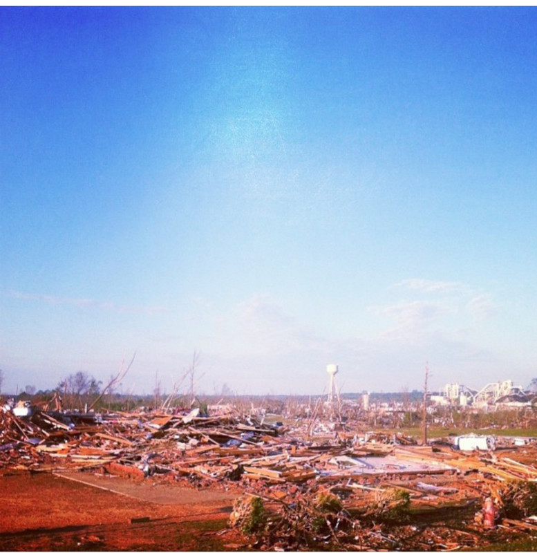
I'm somewhat of a weather geek, but more of a weather enthusiast: I depend on knowing about it for work and play, and when this time of year comes around I, like many, pay extra close attention to what the actual weather geeks say because it has saved my arse quite a few times. Like anyone who takes a direct hit from an EF4 and lives to tell about it, there's many miraculous stories of people surviving a collision of their world with that monster. So many stories, but 10 of them never got to be told.
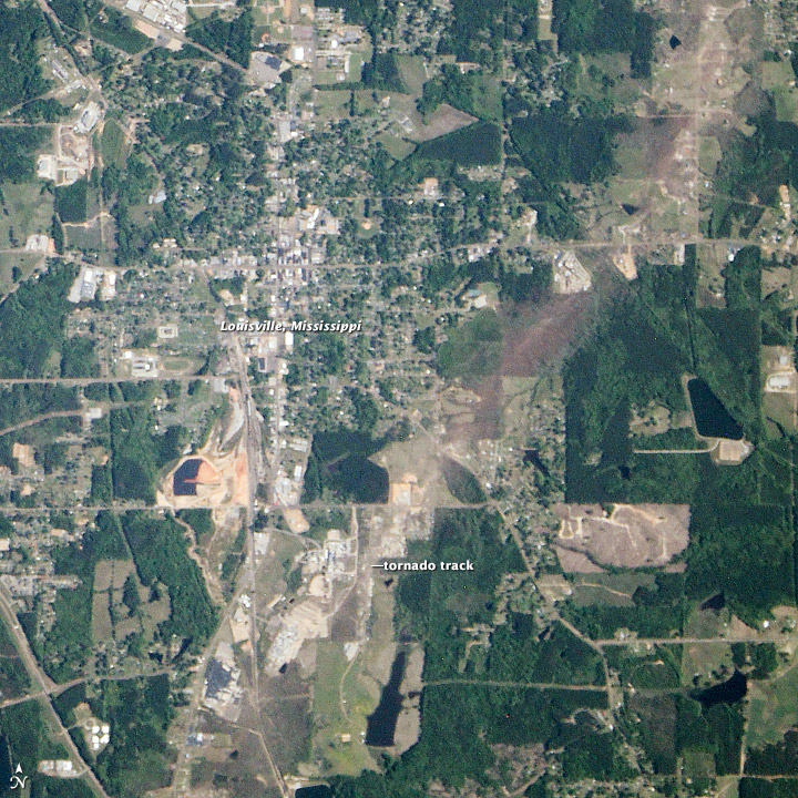
Image from NASA's earth observatory website of the fateful turn that it took that day. It was tracking for over 30 miles and was on course to take Louisville's head clean off in one fell swoop, but it turned as it was just south of the city limits thereby sparing Louisville a fatal blow.
Reed Timmer's video of the 2011 EF5:ETA: Reed calls it Philadelphia and then says claytown. The latter is the proper location of the rural community, but it is a Lousiville zio code. About 5 or 6 miles south of downtown.
YouTube
Video of the 2014 EF4:
YouTube
3 years later on April 28, 2014 in Louisville an EF4 with winds over 185 mph was tracking north, which had it hitting dead nuts in the center of downtown Louisville and main street but thankfully turning at the zero hour when it was just south of town and sparing Louisville proper. It took out the entire SE part of the town though; wiping out a 287,000 square foot Georgia Pacific chip mill ( it is actually Winston Plywood and Veneer both then and now), completely totaling the hospital and its adjacent nursing homes and offices (which all had to be demolished and rebuilt), and leveling multiple neighborhoods killing 10 people total.
In some spots the diameter of significant damage was pushing 1 1/2 miles wide. The Tupelo, MS tornado that struck earlier in the day got most of the publicity (and understandably so due to population size and being the 1st big "hit" of the day), but it was the Louisville tornado that was the true monster.
We were on the ground within 10 minutes of it passing through, and it was a sight to behold, but what I'll remember the most is the sounds, or lack thereof. It was dead silent but it was interspersed by the sounds of distress from people and animals and the landscape recoiling from what had just happened: Wailing and crying, dogs and cats yelping from twisted piles of rubble heaped up in what used to be stands of sawtimber pine trees, calls for help, calls for life, the sound of gas leaking and electricity popping, and the growing chorus of sirens- it was hell on earth. Nothing was happy, and nothing was good.
I snapped this not-very-good-pic of the destruction from Armstrong Street looking back SW from when the tornado first came into the city limits. That used to be a neighborhood and you can see what's left of the chip mill back near the horizon (there used to be a couple hundred thousand sq. ft. of roofing over most of that). I believe a half dozen people or so were killed just in that neighborhood alone. Immediately in front of me is what used to be a sizable church.
I'm somewhat of a weather geek, but more of a weather enthusiast: I depend on knowing about it for work and play, and when this time of year comes around I, like many, pay extra close attention to what the actual weather geeks say because it has saved my arse quite a few times. Like anyone who takes a direct hit from an EF4 and lives to tell about it, there's many miraculous stories of people surviving a collision of their world with that monster. So many stories, but 10 of them never got to be told.
Image from NASA's earth observatory website of the fateful turn that it took that day. It was tracking for over 30 miles and was on course to take Louisville's head clean off in one fell swoop, but it turned as it was just south of the city limits thereby sparing Louisville a fatal blow.
Reed Timmer's video of the 2011 EF5:ETA: Reed calls it Philadelphia and then says claytown. The latter is the proper location of the rural community, but it is a Lousiville zio code. About 5 or 6 miles south of downtown.
YouTube
Video of the 2014 EF4:
YouTube
This post was edited on 4/27/19 at 5:00 pm


Posted on 4/27/19 at 5:28 pm to Bigbee Hills
Judging from that picture, the water tower is the place to be in a tornado.

Posted on 4/27/19 at 6:03 pm to TigerstuckinMS
Haha, that's precisely what I thought when I saw that view. That's one of those weird phenomena that you see associated with tornado damage.
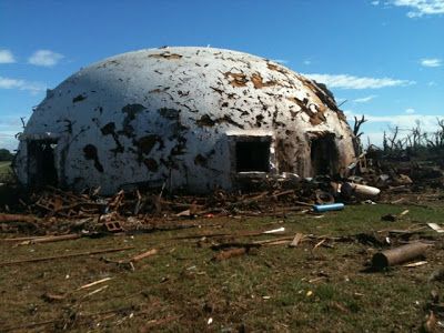
I always wondered if it had something to do with the same concept as monolithic dome homes withstanding high winds. Here's a pic of one that survived a direct hit from a large tornado.
Going along with that, just down the street from there is was one of those metal quonset huts that the base of the tornado passed within a couple hundred yards of, at the most. Other than damage from flying debris, the building itself was completely unscathed and serviceable. They're kind of round as well.
I always wondered if it had something to do with the same concept as monolithic dome homes withstanding high winds. Here's a pic of one that survived a direct hit from a large tornado.
Going along with that, just down the street from there is was one of those metal quonset huts that the base of the tornado passed within a couple hundred yards of, at the most. Other than damage from flying debris, the building itself was completely unscathed and serviceable. They're kind of round as well.


Posted on 4/27/19 at 7:21 pm to tWildcat
quote:
Love Talbots channel, was actually watching the hour and a half el Reno video earlier this week.
My best friend nearly died in this storm. Had been amateur chaser for over a decade.
He’s never covered another a storm. Dude drove over a mile in reverse with the accelerator to the floor.

Posted on 4/27/19 at 7:27 pm to okietiger
Tornadoes in Alabama that day (including both the morning and afternoon events):
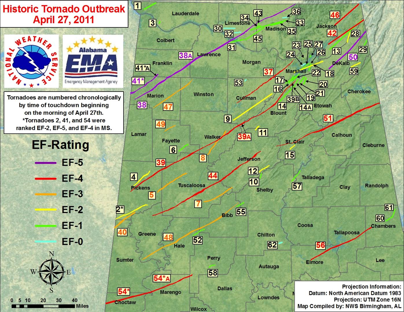
NWS Birmingham April 27, 2011 page
NWS Birmingham April 27, 2011 page

Posted on 4/30/19 at 4:00 pm to Roll Tide Ravens
Didn’t know if I should start a new thread or not but tornados have been popping up in Oklahoma and now Arkansas. This is one near Bergman Arkansas which is close to the Missouri border.
Sorry for the Facebook link.
Facebook video
Sorry for the Facebook link.
Facebook video

Posted on 4/30/19 at 4:11 pm to WhuckFistle
quote:
Didn’t know if I should start a new thread or not but tornados have been popping up in Oklahoma and now Arkansas.
Not sure how busy it would be with SE Ok being the main target this evening, though NW AK/SW MO sitting on the greatest threat for strong tornadoes at this time. SPC rolling a moderate risk update out this afternoon. You know we're getting close to May with Oklahoma starting to get in on the action.
ETA: North of the Metroplex could be in play too. DFW sounding has the right sort of windfield in place for severe stuff this evening.
This post was edited on 4/30/19 at 4:15 pm

Posted on 4/30/19 at 4:25 pm to Duke
I’m trying to follow a station out of Springfield, a few tornadoes confirmed in SW Mo already.
Posted on 4/30/19 at 4:33 pm to MOT
I got, let's call in 2.5 tornadoes near Springfield. One due west of town that's got a severe warning on it but I suspect will get called for a tornado soon.
SW of Springfield near Aurora is about certainly on the ground. Heading right at Aurora, MO too and likely a strong one.
Down near the Arkansas line there's another likely on the ground but not as strong a signal as the above one. Going to track close to Branson, though hopefully just off to it's west.
SW of Springfield near Aurora is about certainly on the ground. Heading right at Aurora, MO too and likely a strong one.
Down near the Arkansas line there's another likely on the ground but not as strong a signal as the above one. Going to track close to Branson, though hopefully just off to it's west.
This post was edited on 4/30/19 at 4:34 pm
Posted on 4/30/19 at 4:36 pm to Duke
The storm in Pecos county was a right turner. Quite obvious on radar.
Posted on 4/30/19 at 4:40 pm to LegendInMyMind
I was about to look for this thread to post a link from April 27. I found this list interesting to see the outbreak in chronological order across the southeast.
LINK
LINK
Posted on 4/30/19 at 4:46 pm to LegendInMyMind
Just had a supercell go north of Lowell, Arkansas into Rogers, Arkansas.

 Page 2 of 3

Popular
Back to top
 Follow TigerDroppings for LSU Football News