- My Forums
- Tiger Rant
- LSU Recruiting
- SEC Rant
- Saints Talk
- Pelicans Talk
- More Sports Board
- Coaching Changes
- Fantasy Sports
- Golf Board
- Soccer Board
- O-T Lounge
- Tech Board
- Home/Garden Board
- Outdoor Board
- Health/Fitness Board
- Movie/TV Board
- Book Board
- Music Board
- Political Talk
- Money Talk
- Fark Board
- Gaming Board
- Travel Board
- Food/Drink Board
- Ticket Exchange
- TD Help Board
Customize My Forums- View All Forums
- Show Left Links
- Topic Sort Options
- Trending Topics
- Recent Topics
- Active Topics
Started By
Message
re: Tornado! Threat Continues Overnight then Shifts East Tomorrow
Posted on 4/2/17 at 8:17 pm to Bullfrog
Posted on 4/2/17 at 8:17 pm to Bullfrog
New watch coming for SW LA to replace the current watch

Mesoscale Discussion 0411
NWS Storm Prediction Center Norman OK
0807 PM CDT Sun Apr 02 2017
Areas affected...Portions of southern/central Louisiana and extreme
southeastern Texas
Concerning...Tornado Watch 110...
Valid 030107Z - 030230Z
The severe weather threat for Tornado Watch 110 continues.
SUMMARY...The threat for damaging winds and a few tornadoes may
increase some across the discussion area over the next 2-3 hours. A
new watch will be issued prior to the 02Z expiration of Tornado
Watch 110 across the Lake Charles, LA county warning area.
DISCUSSION...Opposing propagation and advection vectors have led to
a relatively stationary southwest-northeast band of strong/severe
convection this evening over extreme southeast Texas and
southern/central Louisiana. The 00Z LCH sounding sampled deep
southerly flow which is continuing to transport ample moisture
towards this linear system. Additionally, relatively steep 700-500mb
lapse rates (around 7 C/km) are contributing to MLCAPE values around
2000-3000 J/kg along and to the south of the ongoing complex.
As large-scale forcing for ascent amplifies in response to an
approaching impulse (noted over south-central Texas in water-vapor
imagery), ascending parcels along the southwest edge of this line
should be able to reach their LFC more efficiently. The band will
then likely re-orient in a more meridional fashion as it advances
eastward, encountering an unstable environment with effective SRH
around 200-300 m2/s2. In turn, a threat for damaging winds and a few
embedded tornadoes may increase somewhat within the next 2-3 hours.
A new watch will be issued to replace Watch 110 in the Lake Charles
CWA.
 1
1


Posted on 4/2/17 at 8:20 pm to tgrbaitn08

Posted on 4/2/17 at 8:21 pm to AlxTgr
quote:
A few Alexandria schools are closed tomorrow
I understand that there was some wind damage on McAruthur drive earlier today. I would expect flash flooding, too.

Posted on 4/2/17 at 8:22 pm to NewIberiaHaircut
quote:
We fixin' to get a haircut!!
It will be the best haircut of your life.
Will there be any Lafayette left to look your best for?
Serious question, asking for a friend.
Posted on 4/2/17 at 8:24 pm to ruzil
quote:
Steven Maxwell? @MaxwellKALB
As of now LSUA's campus is still open on Monday.
damn it... still have to work tomorrow (as of right now)
Posted on 4/2/17 at 8:28 pm to rds dc
quote:
New watch coming for SW LA to replace the current watch
Yep, just got the alert Tornado watch until 2am.
Things are intensifying over here, this is as strong as the wind and rain have been for us all day in DeRidder.
Posted on 4/2/17 at 8:44 pm to dgtiger3
Also, much of CenLa is under a flash flood warning with heavy rain expected to continue

Posted on 4/2/17 at 8:46 pm to rds dc
Is the main line expected to speed up as it moves east though La? Seems like it's been moving slow today, but that could be my imagination
Posted on 4/2/17 at 8:50 pm to Glock17
I'm pretty sure it's still moving eastward but very slowly. The threat for flash flooding has increased for SELA from Ascension Parish northwardinto southern Mississippi. If Livingston, EBR, and the Felicianas get 7 or 8 inches or more, we'll be talking about Amite & Comite river stages by Tuesday.

Posted on 4/2/17 at 8:51 pm to TigerstuckinMS
quote:jeez. Like everyone can afford cable. Rabbit ears don't have no Walking dead. So ACM's is it.
Oh. Might I suggest you watch The Walking Dead instead?
Posted on 4/2/17 at 8:51 pm to Glock17
quote:
Is the main line expected to speed up as it moves east though La? Seems like it's been moving slow today, but that could be my imagination
I haven't looked at models this afternoon but, IIRC, they had things moving out faster but the line seems hung up for now. Latest HRRR wants things to start moving along soon, so who knows


Posted on 4/2/17 at 8:56 pm to ruzil
quote:
Will there be any Lafayette left to look your best for?
If it for some reason wipes out Lafayette then I'll do my best to help the community recover. Free haircuts for every baw that can prove his worth.

Posted on 4/2/17 at 8:59 pm to NewIberiaHaircut
Looks like Jackson and Meridian are getting screwed.
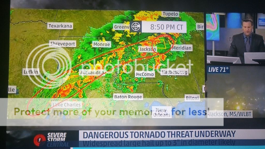
At least the tip, anyway.
At least the tip, anyway.
This post was edited on 4/2/17 at 9:07 pm
Posted on 4/2/17 at 9:05 pm to CajunAlum Tiger Fan
Some places in central Louisiana could end up with 20 inches of rain if this line doeasnt start moving.
LINK
LINK
This post was edited on 4/2/17 at 9:07 pm
Posted on 4/2/17 at 9:06 pm to CajunAlum Tiger Fan
If anyone is staying in a FEMA trailer because your home flooded you might want to stay in your home and get out of the trailer for the night because of the severe weather.
Posted on 4/2/17 at 9:08 pm to Kramer26
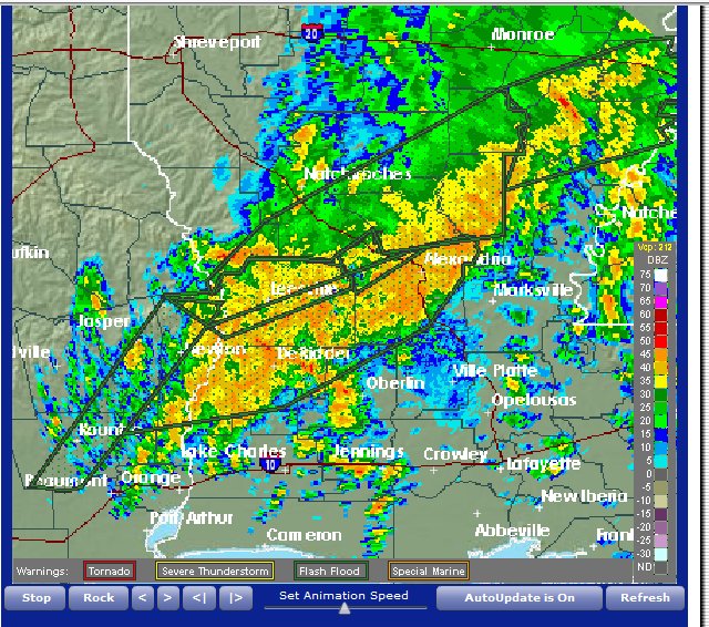
Green boxes are flash flood warnings, Alexandria is officially approaching 8", higher unconfirmed amounts elsewhere
Posted on 4/2/17 at 9:10 pm to NewIberiaHaircut
Can I make an appointment now?
Posted on 4/2/17 at 9:12 pm to rds dc
Holy 8 bit graphics, Batman.

Posted on 4/2/17 at 9:13 pm to LakeViewLSU
quote:
Some places in central Louisiana could end up with 20 inches of rain if this line doeasnt start moving.
Man that is crazy. We went through that here in Ponchatoula in march and august 2016. I pray that this line starts moving soon.
Posted on 4/2/17 at 9:16 pm to Ponchy Tiger
Have you been paying attention to the wind/rivers?
That's what does it. Only takes a little rain. River flood warnings have been issued all day for a reason. They know it won't take much rain to flood below I-12.
That's what does it. Only takes a little rain. River flood warnings have been issued all day for a reason. They know it won't take much rain to flood below I-12.

 Page 43 of 52

Popular
Back to top