- My Forums
- Tiger Rant
- LSU Recruiting
- SEC Rant
- Saints Talk
- Pelicans Talk
- More Sports Board
- Coaching Changes
- Fantasy Sports
- Golf Board
- Soccer Board
- O-T Lounge
- Tech Board
- Home/Garden Board
- Outdoor Board
- Health/Fitness Board
- Movie/TV Board
- Book Board
- Music Board
- Political Talk
- Money Talk
- Fark Board
- Gaming Board
- Travel Board
- Food/Drink Board
- Ticket Exchange
- TD Help Board
Customize My Forums- View All Forums
- Show Left Links
- Topic Sort Options
- Trending Topics
- Recent Topics
- Active Topics
Started By
Message

 1
1

Posted on 4/1/17 at 2:08 pm to Scoop
quote:
Yep. They are inching towards a PDS.
What is a PDS?
Posted on 4/1/17 at 2:12 pm to 4LSU2
Particularly Dangerous Situation.
quote:
It is issued at the discretion of the forecaster composing the watch or warning and implies that there is an enhanced risk of very severe and life-threatening weather, usually a major tornado outbreak or (much less often) a long-lived, extreme derecho event, but possibly another weather hazard such as an exceptional flash flood.[1]
This post was edited on 4/1/17 at 2:14 pm
Posted on 4/1/17 at 2:13 pm to 4LSU2
quote:
What is a PDS?
It stands for Particularly Danerous Situation. It is a designation used in tornado watches (and sometimes severe thunderstorm watches), when the threat is very high. For example, it they believe there could be several strong, long-track, violent tornadoes you might get a PDS Tornado Watch.
They are quite rare, and generally reserved for the very volitile severe weather setups.
Here is a Wikipedia article that explains it pretty well: LINK
This post was edited on 4/1/17 at 2:16 pm
Posted on 4/1/17 at 2:16 pm to Roll Tide Ravens
This is what happens when we don't have a major hurricane in years.
One way or another mother nature is busting a nut on that face.
One way or another mother nature is busting a nut on that face.
Posted on 4/1/17 at 2:19 pm to Roll Tide Ravens
Posted on 4/1/17 at 2:23 pm to rds dc
Awesome thanks!

Posted on 4/1/17 at 2:26 pm to 4LSU2
The definitions above explain what a PDS is but to sum it up it is basically the most extreme warning the SPC issues. It basically means they have high confidence that an event is going to produce life threatening situations over a large area.
They only break it out a dozen or two times a year.
It feels like we may get one tomorrow, possibly with the next update.
They only break it out a dozen or two times a year.
It feels like we may get one tomorrow, possibly with the next update.
Posted on 4/1/17 at 2:28 pm to Scoop
quote:
The definitions above explain what a PDS is but to sum it up it is basically the most extreme warning the SPC issues. It basically means they have high confidence that an event is going to produce life threatening situations over a large area. They only break it out a dozen or two times a year. It feels like we may get one tomorrow, possibly with the next update.
A PDS goes with the watch, so there won't be anything PDS until they issue a tornado watch tomorrow (if it is a PDS). In the next outlook, though, they may go to a high risk, but that is different from PDS. PDS is not directly related to the outlooks, but to watches.
This post was edited on 4/1/17 at 2:30 pm
Posted on 4/1/17 at 2:33 pm to lsuman25
quote:
Pretty serious wording in this new update
...East Texas into Louisiana -- Midday through evening...
The fast erosion of any capping inversion Sunday morning and
widespread destabilization of the air mass lends uncertainty to
exact placement and timing of tornadic supercell development, with a
potential extending from east TX to New Orleans, and timing anywhere
from midday through evening across the warm sector. Some models such
as the ECMWF produce storms over southeastern LA during day, and the
environment would already be favorable for tornadoes. However, the
most likely scenario is for supercells to begin developing by
midday, near the warm front and intensifying low-level jet core
which will be across east TX into western LA, then eventually
spreading eastward as the cold front approaches from the west. At
least a few strong tornadoes are expected given large looping
hodographs with effective SRH in excess of 300 m2/s2 along with
impressive instability profiles. Overnight, cells may merge into a
QLCS, with both tornado and damaging wind threat persisting into
Monday morning.

Posted on 4/1/17 at 2:40 pm to rds dc
So is DFW weather dependent on timing of the storms firing off? Feels like were in the middle of just another rainmaker and December Rowlett EF-4
Posted on 4/1/17 at 2:40 pm to Roll Tide Ravens
Wasn't there a PDS issued just before the outbreak last year which included the LaPlace tornado and the ones in the bayou area?
Posted on 4/1/17 at 2:44 pm to Roll Tide Ravens
Ok. I see the next update will be midnightish and that will be too early for watches. We'll probably know if they issue a PDS first thing in the morning, though, because the watches are gonna be issued early as the latest update anticipates super cell formation starting 7am to 10am.
Posted on 4/1/17 at 2:47 pm to LSUFanHouston
quote:
Wasn't there a PDS issued just before the outbreak last year which included the LaPlace tornado and the ones in the bayou area?
Yes.
Posted on 4/1/17 at 4:45 pm to Scoop
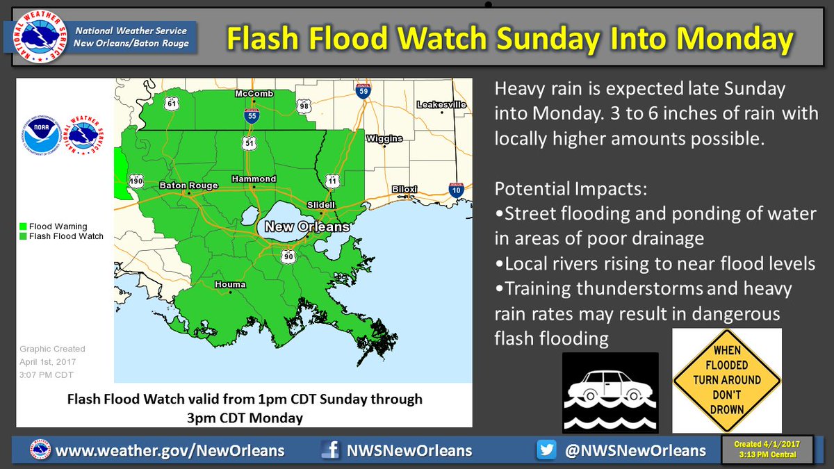
There will also be a heavy rain threat with this system and the NWS has issued a watch
Posted on 4/1/17 at 4:48 pm to rds dc
Latest 3K NAM simulated radar for tomorrow:

Posted on 4/1/17 at 4:58 pm to rds dc
This latest one looks like it is moving the heart of the action north as opposed to the earlier one.
Am I seeing that right?
Am I seeing that right?

Posted on 4/1/17 at 5:00 pm to rds dc
So what times this shite supposed to be rolling through? Weather Bug is showing not until 5-6pm.
Posted on 4/1/17 at 5:34 pm to lsuhunt555
SPC has super cells firing in the morning when the sun gets going between Austin and Dallas.
It's gonna start early.
If you are in SELA you will have plenty of time to see how things shake out.
It's gonna start early.
If you are in SELA you will have plenty of time to see how things shake out.
Posted on 4/1/17 at 6:03 pm to Scoop
I'm in CenLa. So midday?

 Page 3 of 52

Popular
Back to top