- My Forums
- Tiger Rant
- LSU Recruiting
- SEC Rant
- Saints Talk
- Pelicans Talk
- More Sports Board
- Fantasy Sports
- Golf Board
- Soccer Board
- O-T Lounge
- Tech Board
- Home/Garden Board
- Outdoor Board
- Health/Fitness Board
- Movie/TV Board
- Book Board
- Music Board
- Political Talk
- Money Talk
- Fark Board
- Gaming Board
- Travel Board
- Food/Drink Board
- Ticket Exchange
- TD Help Board
Customize My Forums- View All Forums
- Show Left Links
- Topic Sort Options
- Trending Topics
- Recent Topics
- Active Topics
Started By
Message
re: Tornado! Threat Continues Overnight then Shifts East Tomorrow
Posted on 4/1/17 at 10:04 pm to GEAUXmedic

Posted on 4/1/17 at 10:04 pm to GEAUXmedic
great work... Give me a timeline buddy................ 
 0
0


Posted on 4/1/17 at 10:06 pm to TigerinPurgatory
Latest from NWS:
Area Forecast Discussion
National Weather Service New Orleans LA
402 PM CDT Sat Apr 1 2017
.SHORT TERM... A nice evening and overnight before the weather transitions to a strong convective regime during the day Sunday. Temperatures tonight should be on the mild side but may nudge upward a few degrees prior to sunrise on warm air advection off the gulf. Sunday still appears to be shaping up to be a hyperactive weather day. Low pressure system currently spinning over central New Mexico will continue to dig a bit more while moving into Texas this evening. This will induce warm frontogenesis across the gulf that will move inland early Sunday, bringing a focal point upon which a strengthening onshore flow gradient will converge. Increasing omega and upper level divergence over the area along with low level convergence on a tightening onshore gradient during the afternoon and evening hours Sunday. It was decided through a collaborative effort that the ECMWF is the preferred solution on timing and location of the heavier impact weather, which is decidedly more south of the GFS solution. The general QPF for the period has been maintained at 3 to 6 inches with locally higher amounts possible due to any echo training that may likely occur. Regarding severe weather potential, it does appear all modes will be possible given the degree of low level speed and some directional shear to develop for tornado potential along with steep lapse rates and storm top divergence for adequate hail generation. The CHAP output on both the NAM and GFS does ping on a high risk situation, showing a Ricks Index at or above 200, which is typically a Particularly Dangerous Situation range. If model soundings are correct, these values show potential of EF-4 tornadoes with rotational velocities close to 200 kt, 95 kt gust potential and golf ball to baseball sized hail potential. Be mindful these are just potentials at this point, but does shed light on the Moderate Risk area currently depicted by SPC over SE Texas and SW Louisiana on the Day 2 outlook. One degree of uncertainty will be how much precipitation loading takes place to diminish the severity threat? It does appear in the CHAP guidance that the severe weather threat is greatest at onset and transitions to heavy rain as the event unfolds.

Posted on 4/1/17 at 10:10 pm to GEAUXmedic
Well shite looks like I better hunker down tonight and keep the phone/tablet/flashlight close to me. As well as the cats kennel 
Posted on 4/1/17 at 10:22 pm to GEAUXmedic
Are we looking at another flood scenario fot SELA?
Posted on 4/1/17 at 10:29 pm to Jim Rockford
am I going to die in Pineville tomorrow? 
Posted on 4/1/17 at 10:31 pm to Jim Rockford
6-8 inches...
Posted on 4/1/17 at 10:32 pm to dukke v
quote:
6-8 inches...
TWSS
This post was edited on 4/1/17 at 10:33 pm

Posted on 4/1/17 at 10:33 pm to GEAUXmedic
I'll see you guys in the morning. Cleared my schedule so I can rabbit hole on this tomorrow.
Posted on 4/1/17 at 10:35 pm to GEAUXmedic
so there is a small degree of uncertainty that we don't get a heavy rain shield and we end up with a PDS severe weather outbreak? frick
This post was edited on 4/1/17 at 10:36 pm
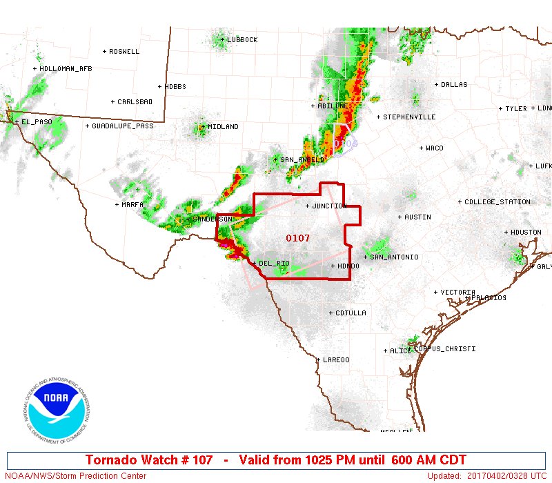
Posted on 4/1/17 at 10:56 pm to Scoop
1st Tornado Watch of the event

Posted on 4/1/17 at 11:02 pm to GEAUXmedic
quote:
these values show potential of EF-4 tornadoes with rotational velocities close to 200 kt, 95 kt gust potential and golf ball to baseball sized hail potential.
Posted on 4/1/17 at 11:09 pm to When in Rome
quote:
200 kt
230 MPH
that's not fast or anything
Posted on 4/1/17 at 11:12 pm to GEAUXmedic
quote:
NUMBER OF TORNADOES EXPECTED: 30-75 – CONFIDENCE: Normal
Tornado Hot-spot: Eastern Texas, Louisiana
Pros: Moderate to high instability, good/excellent speed and directional shear, decent upper-level dynamics, and excellent low-level moisture.
Cons: Extensive cloud cover, some low-level capping, potential for veer-back-veer wind profiles in the western parts of the threat area, and potential for storms to grow upscale quickly. All risk limiting the amount of long-lived supercells.
I mentioned this earlier and still think this could be the thing that keeps tomorrow from really going off the scale. The latest HRRR run does seem to show a bunch of discrete cells out ahead of the main line, that would be problematic.
HRRR

Posted on 4/1/17 at 11:16 pm to DVinBR
By what day and time should the most severe weather and threats be over in South Louisiana?
Posted on 4/1/17 at 11:17 pm to rds dc
quote:
rds dc
Great work as usual.
Posted on 4/1/17 at 11:18 pm to rds dc
as a lover of helping to spread breaking news... when should I be on to help with watch/warning alerts?
Posted on 4/1/17 at 11:34 pm to rds dc
Storms already firing over N. Texas

Posted on 4/1/17 at 11:42 pm to rds dc
line of storms forming between Dallas & Tyler ahead of the main front which hasn't made it to Fort Worth yet
Posted on 4/1/17 at 11:43 pm to LSUperior
Anyone know when the worst of it will be heading into the Batom Rouge and Lafayette region?
What to expect?
What to expect?
Posted on 4/1/17 at 11:53 pm to member12
quote:
Anyone know when the worst of it will be heading into the Batom Rouge and Lafayette region?
What to expect?
Lots of uncertainty when it comes to timing and threat. Here is the 00z 3K NAM is showing:


 Page 5 of 52

Popular
Back to top