- My Forums
- Tiger Rant
- LSU Recruiting
- SEC Rant
- Saints Talk
- Pelicans Talk
- More Sports Board
- Coaching Changes
- Fantasy Sports
- Golf Board
- Soccer Board
- O-T Lounge
- Tech Board
- Home/Garden Board
- Outdoor Board
- Health/Fitness Board
- Movie/TV Board
- Book Board
- Music Board
- Political Talk
- Money Talk
- Fark Board
- Gaming Board
- Travel Board
- Food/Drink Board
- Ticket Exchange
- TD Help Board
Customize My Forums- View All Forums
- Show Left Links
- Topic Sort Options
- Trending Topics
- Recent Topics
- Active Topics
Started By
Message
 3
3

Posted on 4/2/17 at 10:31 am to meauxjeaux2
Weather Channel chica gonna learn it's Parishes, not Counties in Louisiana

Posted on 4/2/17 at 10:32 am to meauxjeaux2
quote:at this point any one of those tiny cells could become a threat... might as well pick one at random if you want to place bets
Cell over Plaquemine is rapidly intensifying and could pose a thread to Praireville
Posted on 4/2/17 at 10:32 am to rt3
radar indicating 4" (yes... FOUR INCH) hail in the tornado warned area

Posted on 4/2/17 at 10:32 am to rt3
I have to drive to Abilene today. All of north and central Texas is covered.
This should be fun.
This should be fun.
Posted on 4/2/17 at 10:35 am to Salmon
quote:
I have to drive to Abilene today. All of north and central Texas is covered.
This should be fun.


Posted on 4/2/17 at 10:35 am to baytiger

Posted on 4/2/17 at 10:36 am to rds dc
quote:
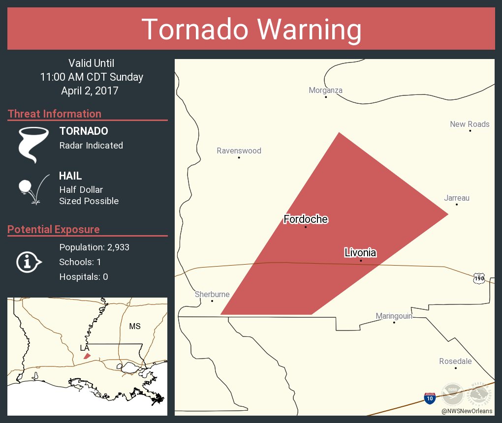
The National Weather Service in New Orleans has issued a
* Tornado Warning for... South central Pointe Coupee Parish in southeastern Louisiana...
* Until 1100 AM CDT
* At 1031 AM CDT, a severe thunderstorm capable of producing a tornado was located near Atchafalaya National Wildlife Refuge, or near Krotz Springs, moving northeast at 20 mph. HAZARD... Tornado and half dollar size hail. SOURCE... Radar indicated rotation. IMPACT... Flying debris will be dangerous to those caught without shelter. Mobile homes will be damaged or destroyed. Damage to roofs, windows, and vehicles will occur. Tree damage is likely.
* This dangerous storm will be near... Lottie around 1050 AM CDT. Fordoche around 1055 AM CDT. Livonia around 1100 AM CDT. PRECAUTIONARY/PREPAREDNESS ACTIONS... Heavy rainfall may hide this tornado. Do not wait to see or hear the tornado. TAKE COVER NOW!
Posted on 4/2/17 at 10:37 am to Salmon
This weak cap might prevent a lot of tornadoes from occurring. I still think there will be a few big ones by the time it's all said and done.
Seems like in my neck of the woods the cap is too strong anytime there is a chance of severe weather. Preventing anything from exploding upward.
Seems like in my neck of the woods the cap is too strong anytime there is a chance of severe weather. Preventing anything from exploding upward.
Posted on 4/2/17 at 10:38 am to rds dc
That is not good.  Lite rain now.
Posted on 4/2/17 at 10:39 am to rt3
my phone blowing up for a new tornado watch... don't know how big the area is but it covers CenLA at least
Posted on 4/2/17 at 10:40 am to razorbackfan4life
quote:a weak cap can actually aid supercell development. prevents everything from blowing up into a big MCS so you get lots of discrete cells with strong updrafts where the cap does break.
This weak cap might prevent a lot of tornadoes from occurring. I still think there will be a few big ones by the time it's all said and done.
Posted on 4/2/17 at 10:41 am to rds dc
My friend is driving into Krotz Springs now.
Posted on 4/2/17 at 10:42 am to chinhoyang
new tornado watch that now covers me


Posted on 4/2/17 at 10:43 am to rt3
quote:I wouldn't put too much stock in that. I mean of course it's possible but like we were discussing earlier the storm is kind of in a radar dead zone which makes the data less reliable.
radar indicating 4" (yes... FOUR INCH) hail in the tornado warned area
Posted on 4/2/17 at 10:44 am to baytiger
quote:
I wouldn't put too much stock in that. I mean of course it's possible but like we were discussing earlier the storm is kind of in a radar dead zone which makes the data less reliable.
weather channel saying it like it's gospel truth
Posted on 4/2/17 at 10:44 am to chinhoyang
So, is there a tornado coming towards New Roads area?
Posted on 4/2/17 at 10:45 am to baytiger
In New Roads with my mom right now and the TV is out....keep me posted please? Trying to keep up on here but hard to
This post was edited on 4/2/17 at 10:52 am
Posted on 4/2/17 at 10:45 am to rt3
quote:yeah and steph abrams thinks the atmosphere is a hamburger, what's your point?
weather channel saying it like it's gospel truth

 Page 14 of 52

Popular
Back to top