- My Forums
- Tiger Rant
- LSU Recruiting
- SEC Rant
- Saints Talk
- Pelicans Talk
- More Sports Board
- Fantasy Sports
- Golf Board
- Soccer Board
- O-T Lounge
- Tech Board
- Home/Garden Board
- Outdoor Board
- Health/Fitness Board
- Movie/TV Board
- Book Board
- Music Board
- Political Talk
- Money Talk
- Fark Board
- Gaming Board
- Travel Board
- Food/Drink Board
- Ticket Exchange
- TD Help Board
Customize My Forums- View All Forums
- Show Left Links
- Topic Sort Options
- Trending Topics
- Recent Topics
- Active Topics
Started By
Message

 2
2


Posted on 4/20/20 at 1:04 am to NOLA1128
quote:
My uncle just confirmed, after driving around his house near Old Mandeville, there is an obvious path of tree damage. Something likely touched down there. My heart goes out to those in Central MS and AL...
No kidding. We might joss back and fourth about football but this is real stuff right here. Prayers to anyone hit by this system.
Posted on 4/20/20 at 1:05 am to rt3
quote:
can someone find G The Tiger Fan, please???
I didn’t even think about G til I started catching up on the thread, I sure hope he’s ok (pls don’t tell him I said that)
Posted on 4/20/20 at 1:07 am to rt3
Anyone in Alabama or Georgia got an update on anything?
Posted on 4/20/20 at 1:14 am to rt3
Listening to fire dispatch in Marion county, Ms. Some guy just radioed in that he just came up on an area that looks like a giant bulldozer came thru and flattened everything. Betcha that area was in the path of that tornado.
This , after 5 hours later of cutting and removing trees so they can reach people they couldn’t earlier. I hope it’s just a rural area of trees but I gotta feeling we gonna hear casualties in multiple states once this is over.
This , after 5 hours later of cutting and removing trees so they can reach people they couldn’t earlier. I hope it’s just a rural area of trees but I gotta feeling we gonna hear casualties in multiple states once this is over.
Posted on 4/20/20 at 1:17 am to MullenBoys
If you have an iphone, download the free 5-0 Radio app. It’s basically a police scanner and you pick USA, then click on which state then click on what county or in Louisiana’s case, which parish.
Posted on 4/20/20 at 2:00 am to fightin tigers
Found the guy who works for yeah trees!

Posted on 4/20/20 at 2:02 am to MullenBoys
quote:
We might joss back and fourth about football but this is real stuff right here.
It could be any of us. Sometimes it's Louisiana, Arkansas, bama, georgia, florida..
Severe storms have become a way of life for the south. We know what it's like to wake up at 3AM with no power, no air conditioner and wall shaking thunder. Aside from a tornado..you're having to hope things like, no damn trees falling on the house, car, power lines or roads..we're all united in severe weather.
This post was edited on 4/20/20 at 2:08 am
Posted on 4/20/20 at 2:05 am to BRIllini07
quote:
Found the guy who works for yeah trees!
I wish man.
Reminds of my days landscaping, spend all day in the fresh air, make enough money to make things happen, love their jobs and live life.
I wish I could have made enough to live the life I wanted doing what they do.
instagram link that may work
wally wally world yeah trees remix
This post was edited on 4/20/20 at 2:10 am
Posted on 4/20/20 at 4:46 am to SEClint
quote:
Severe storms have become a way of life for the south. We know what it's like to wake up at 3AM with no power, no air conditioner and wall shaking thunder. Aside from a tornado..you're having to hope things like, no damn trees falling on the house, car, power lines or roads..we're all united in severe weather.
Not burst your bubble, but weather events like this have always happened.
There is no magic formula as to when and where. Weather forecasting is getting better through technology, but the ones that present it us are ones that need scale it back a notch or 2.
You only hear more about severe weather because TV stations namely local news and the weather channel have advertising to sell in the name of safety.
That is why they ratchet up the fear factor to these events. Not to mention some even support the global climate change agenda.

Posted on 4/20/20 at 7:01 am to im4LSU
That's really close to where my son is. He lost power but that was all. His girlfriend lives just off Hardy and had about an inch of water in her house.
Posted on 4/20/20 at 7:18 am to Geauxlden Eagle
I have a place in Foxworth and according to my neighbor, we lost power but its back on now. Tornado passed about 1 mile north of us.
Prayers go out to all, She also said something about Downtown Columbia had some flooding.
Prayers go out to all, She also said something about Downtown Columbia had some flooding.
Posted on 4/20/20 at 8:43 am to MullenBoys
It got pretty rough around here in the lower southeast corner of Alabama. We had a few tornado warnings for our counties but what was messed up was the storm took out fort Rucker radar and Tallahassee radar wasn't working. The local meteorologists couldn't make head or tails of velocity scans without them. Interesting because with Tallahassee being out Houston Texas was issuing warnings for us and they just lit everything up with severe thunderstorm warnings even though the threat was gone.

Posted on 4/20/20 at 8:45 am to Mohican
quote:
Crossing the river and putting down north of Vicksburg, then on to Yazoo, Holmes, Attalla, Choctaw Counties are like bowling lane.
Seems like the same down south around Laurel, Ellisville.
Definitely some microclimate patterns with nados. Also with trying to find the snow/rain crossover line in winter. Cold air spills through the delta and then hits the hills to slow down and it regularly follows a pattern.
quote:That is possibly the best way I've seen it described: The geospatial correlation of tornadoes, especially big violent tornadoes, in these micro "tornado alleys" is precisely like a bowling lane, and the poor SOB's in the "Yazoo, Holmes, Attalla, Choctaw" progression are the bowling pins that wait and watch helplessly as the old pro lines up to strike them out.
Crossing the river and putting down north of Vicksburg, then on to Yazoo, Holmes, Attalla, Choctaw Counties are like bowling lane.
Seems like the same down south around Laurel, Ellisville.
And to scale those counties down to even tighter geographic alleyway, you could take it a step further with the "baby split" bowling move (had to Google "bowling moves" to get that one) where the pro is tactical about taking out individual remaining pins: The repetitive preciseness with how large tornadic storms follow the same general super-specific pathways puts certain communities within those countywide tornadic alleyways directly in the crosshairs more so than others.
For the sake of continuity and sticking with counties you named, take Attala and Choctaw counties for an example of the bowling pins that remain the sole focus of the bowling ball: Attala county examples could be the southeastern part of the Hesterville and also the McCool communities, and Choctaw county examples could be the aforementioned Chester community along with the area along and south of the Natchez Trace Parkway near French Camp going in a southernly direction down towards Weir, MS:

So within those counties are even tighter windows in which to roll the ball, and what's even more interesting is that upon visual inspection it seems that the farther east you go the more apparent the intensification of clustering becomes- even though this phenomena crops up randomly across the map, the correlation seems to be more apparent the more you pan eastward. (The disclaimer to this supposition is found in the key word "seems," as there is a difference between what the eye sees on a map and actual statistical & mathematical proof using geospatial analysis, but make no mistake: An observant eye noticing trends on a map that was made for a different set of reasons has been the catalyst for more GIS analysis studies than any blind, mathematical theorization. That's the beauty and science of maps: They are art and science, and they can be both right and wrong [and definitely wrong], but they speak to each observer in their own way but with a common theme.)
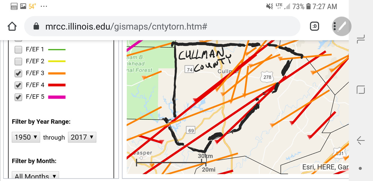
And regarding the intensified clustering as you go farther east, it seems as though there are several counties in Alabama where violent tornadoes begin to spread out over wider, more countywide "volatile corridors," but unfortunately for them the number of tornadoes increases exponentially. Cullman County, Alabama is a good example of this theoretical correlation between expanding tornadic "micro-alleyways" with intensified clustering as you go further east in certain areas, i.e., it's a bigger target area and you've got more bullets to shoot at it with:
One thing that does not warrant the "seems to be" disclaimer is this: There are some counties in Alabama where I'd be extremely apprehensive to live in because of the number of violent twisters that they have pass through; because 1 EF4 going through my community every 30 years is one too many, let alone every 20 years (and GIS analysis says that incident rate is becoming more and more common in Dixie Alley).
Cullman county (ESPECIALLY the SW to NE corridor) is a good example of this, but if I were an actuator looking to utilize these maps for insurance purposes, the folks from Pelham, AL north to Decatur, AL would see some rate increases- they are ALWAYS dealing with rotating thunderstorms that wind up shitting out one violent tornado after another:
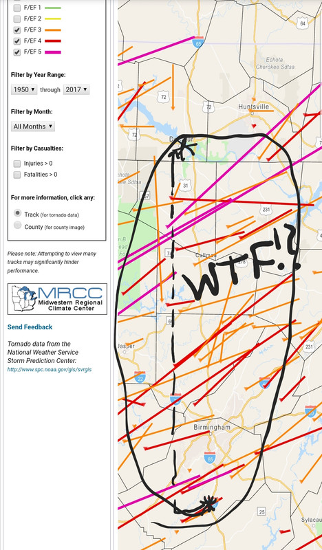
I already have some stuff from 2014, but one of these days I'm going to sit down and run some GIS analysis models on this theory. It will be then that I find out some guys and gals way smarter than myself have already figured out it's a dead end, but regardless it's a peculiarly interesting discussion and I truly believe it to be a prudent decision for everyone in Dixie Alley to take a look at their home area and visually look for any trends: One day in the future if your mind is wondering elsewhere, if it's thinking of a hundred different things on a day where there are a hundred different storms surrounding you, then looking at and remembering that map might be what gives you enough pause to notice that a particularly dangerous thunderstorm has lined up, cocked back, and poised itself to send a burner ball down your lane- it did for me.
Posted on 4/20/20 at 8:56 am to Tarps99
quote:. I appreciate the advances,but you are so right.
...but the ones that present it us are ones that need scale it back a notch or 2.
It was much better when we had Nash Roberts with his blackboards on Channel 4.
You only got the weather from the TV four times a day (6am,noon, 5pm,10pm) or on the radio.
This post was edited on 4/20/20 at 9:05 am
Posted on 4/20/20 at 10:00 am to Bigfishchoupique
who wants to start the Wednesday thread?

Posted on 4/20/20 at 10:05 am to rt3
quote:
who wants to start the Wednesday thread?
Go for it. And I expect TDSGumbo and Deltaland to post on the first page with their panties in a wad about it.
Posted on 4/20/20 at 10:50 am to notiger1997
confirmed tornado on the ground south of Sanford, Fla. east of I-4
heading straight to Geneva, Fla.
all part of our severe weather system yesterday
heading straight to Geneva, Fla.
all part of our severe weather system yesterday
Posted on 4/20/20 at 11:00 am to rt3
there's a very strong looking rotation just off the coast of Edgewater, Fla.
Posted on 4/20/20 at 12:13 pm to rt3
TWC has video of the tornado in Sanford, Fla. earlier today

 Page 32 of 34

Popular
Back to top