




- My Forums
- Tiger Rant
- LSU Recruiting
- SEC Rant
- Saints Talk
- Pelicans Talk
- More Sports Board
- Fantasy Sports
- Golf Board
- Soccer Board
- O-T Lounge
- Tech Board
- Home/Garden Board
- Outdoor Board
- Health/Fitness Board
- Movie/TV Board
- Book Board
- Music Board
- Political Talk
- Money Talk
- Fark Board
- Gaming Board
- Travel Board
- Food/Drink Board
- Ticket Exchange
- TD Help Board
Customize My Forums- View All Forums
- Show Left Links
- Topic Sort Options
- Trending Topics
- Recent Topics
- Active Topics
Started By
Message
re: Tornado! Louisiana and Mississippi Edition
Posted on 11/29/16 at 6:07 pm to rds dc


Posted on 11/29/16 at 6:07 pm to rds dc
Lowndes, Oktibbeha [MS]) till 6:15 PM CST. AT 555 PM CST...A CONFIRMED TORNADO WAS LOCATED NEAR OKTOC...OR 10 MILES SOUTHEAST OF STARKVILLE...MOVING NORTHEAST AT 30 MPH.
NOXUBEE, MS AT 558 PM CST...A CONFIRMED LARGE AND EXTREMELY DANGEROUS TORNADO WAS LOCATED NEAR MASHULAVILLE...OR 10 MILES NORTH OF PRESTON...MOVING NORTHEAST AT 35 MPH.
9 N PRESTON MS - 11/30 00:01Z
Very large tornado doing damage 3 miles north of current location. Significant power flashes with large trees down on Butler Road. --Brett Adair\
NOXUBEE, MS AT 558 PM CST...A CONFIRMED LARGE AND EXTREMELY DANGEROUS TORNADO WAS LOCATED NEAR MASHULAVILLE...OR 10 MILES NORTH OF PRESTON...MOVING NORTHEAST AT 35 MPH.
9 N PRESTON MS - 11/30 00:01Z
Very large tornado doing damage 3 miles north of current location. Significant power flashes with large trees down on Butler Road. --Brett Adair\
 0
0

Posted on 11/29/16 at 6:11 pm to SouthernHog
quote:
Be careful baws
That cell went west of me but we got a hell of a lightning show though. I fell sorry for the ppl in the Colombia & Winnsboro areas. They are getting hit by almost everyone of these cells.


Posted on 11/29/16 at 6:20 pm to rds dc
I'm in Columbia, MS tonight. Am I in the clear or am I fricked? Looks like shite is headed my way.
Posted on 11/29/16 at 6:21 pm to rds dc
That's good and encouraging
Posted on 11/29/16 at 6:30 pm to jamalsdeck
tornado about to cross into Alabama

Posted on 11/29/16 at 6:34 pm to GEAUXmedic
This guy right here is in a shitty spot.

Posted on 11/29/16 at 6:36 pm to GEAUXmedic
quote:
This guy right here is in a shitty spot.
Nighttime, tornado and, oh yeah, Mississippi... That is the formula for shitty locations
Posted on 11/29/16 at 6:38 pm to dukke v
quote:
Its just so damn warm and sticky in South LA... That means trouble when A storm can just pick it up.....
Yeah mother nature can just pick it up and she can pick it up fast. I'm in NELA and I got the alert on my cell phone about possible bad weather ~3:15 this afternoon. I went outside to help my brother and his employees get all the tractors and trucks under the sheds because they were predicting hail. It was hot and muggy with a few clouds but nothing too ominous. ~3:45 the sky got dark and the temperature fell a noticeable bit, and ~3:50 my arse was diving in the closet and throwing pillows on top of my spinal cord.

Posted on 11/29/16 at 6:40 pm to NewIberiaHaircut
Columbia should be far enough south to be out of the worst of it.

Posted on 11/29/16 at 6:44 pm to SaltyMcKracker
I'm ok so far everybody.
Figured numerous posters are concerned.
Figured numerous posters are concerned.
Posted on 11/29/16 at 6:45 pm to SaltyMcKracker
by contrast, columbia might be far enough north that they have issues overnight.
Posted on 11/29/16 at 6:54 pm to GEAUXmedic
Warned cell north of De Ridder could be trouble later on for Alexandria
This post was edited on 11/29/16 at 6:55 pm
Posted on 11/29/16 at 6:57 pm to rds dc
Latest sounding from NOLA:
Area Forecast Discussion
National Weather Service New Orleans LA
654 PM CST Tue Nov 29 2016
...SOUNDING DISCUSSION...
An unstable and moist airmass is in place across the region this
evening. MLCAPE values are around 1600 J/kg with a lifted index of
-4 so there is plenty of instability. Shear is also quite present
with 0-1km SRH value near 250m2/s2 and effective 0-6km shear of 63
knots. Between 1500 and 8500 feet winds are between 25 and 35
knots so there is not a great speed shear, but it is better going
from the surface to 500mb. There is good directional shear with
winds in the low levels veering from the south-southeast at the
surface rotating clockwise and blowing from the south-southwest
by 850mb/5000 feet and from the southwest by 700mb/10000 feet. LCL
heights are near 1000 feet/300m. All of these would be supportive
of at least a few tornadoes. There are a couple of limiting
factors currently to more widespread thunderstorm development over
our forecast area. First, lapse rates are relatively weak and
generally less than 6.5C/km. Secondly, a temperature inversion is
present near 9900 feet, which may limit convection initially until
better lift overspreads the area later tonight.
As far as the damaging wind threat, downdraft CAPE values are
above 1100 J/kg, which is favorable. Quite a bit of dry air
resides between 7000 and 30000 feet, which could be entrained into
thunderstorm downdrafts and reach the surface. Hail is a lesser
threat as the wet-bulb zero height near 10000 feet and freezing
level of 13850 feet are a bit high unless vigorous updrafts can be
realized.
Additional radiosonde releases are planned for around 3z/9pm and
6z/midnight to aid in assessing the severe weather threat.
00z balloon info: A successful flight reaching a height of 20.8 miles
above the ground bursting over Chunchula, AL 104 miles downrange
from the office. The ascent 101 minutes.
Area Forecast Discussion
National Weather Service New Orleans LA
654 PM CST Tue Nov 29 2016
...SOUNDING DISCUSSION...
An unstable and moist airmass is in place across the region this
evening. MLCAPE values are around 1600 J/kg with a lifted index of
-4 so there is plenty of instability. Shear is also quite present
with 0-1km SRH value near 250m2/s2 and effective 0-6km shear of 63
knots. Between 1500 and 8500 feet winds are between 25 and 35
knots so there is not a great speed shear, but it is better going
from the surface to 500mb. There is good directional shear with
winds in the low levels veering from the south-southeast at the
surface rotating clockwise and blowing from the south-southwest
by 850mb/5000 feet and from the southwest by 700mb/10000 feet. LCL
heights are near 1000 feet/300m. All of these would be supportive
of at least a few tornadoes. There are a couple of limiting
factors currently to more widespread thunderstorm development over
our forecast area. First, lapse rates are relatively weak and
generally less than 6.5C/km. Secondly, a temperature inversion is
present near 9900 feet, which may limit convection initially until
better lift overspreads the area later tonight.
As far as the damaging wind threat, downdraft CAPE values are
above 1100 J/kg, which is favorable. Quite a bit of dry air
resides between 7000 and 30000 feet, which could be entrained into
thunderstorm downdrafts and reach the surface. Hail is a lesser
threat as the wet-bulb zero height near 10000 feet and freezing
level of 13850 feet are a bit high unless vigorous updrafts can be
realized.
Additional radiosonde releases are planned for around 3z/9pm and
6z/midnight to aid in assessing the severe weather threat.
00z balloon info: A successful flight reaching a height of 20.8 miles
above the ground bursting over Chunchula, AL 104 miles downrange
from the office. The ascent 101 minutes.
Posted on 11/29/16 at 6:59 pm to GEAUXmedic
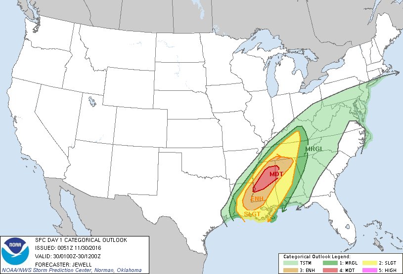
latest spc outlook:
Posted on 11/29/16 at 7:05 pm to GEAUXmedic
quote:
...SOUNDING DISCUSSION...
LLJ is still weakish and there is still a bit of a cap. Both of those should change as the night goes on but timing of those changes and timing of SW moving out of Texas will determine storm mode later.
Posted on 11/29/16 at 7:08 pm to rds dc
Starting to get initialization in the west.

Posted on 11/29/16 at 7:14 pm to GEAUXmedic
quote:
Starting to get initialization in the west.
Now wait and see if SPC pulls the trigger.
Posted on 11/29/16 at 7:17 pm to rds dc
Latest SPC outlook extended the hatched tornado risk to include Baton Rouge, Lafayette


Posted on 11/29/16 at 7:19 pm to rds dc
Hoping the LLJ stays low here, but wind has picked up in the BR area. I know ground level doesnt exactly translate, but not what i was hoping to see.

 Page 5 of 10

Popular
Back to top
 Follow TigerDroppings for LSU Football News