




- My Forums
- Tiger Rant
- LSU Recruiting
- SEC Rant
- Saints Talk
- Pelicans Talk
- More Sports Board
- Fantasy Sports
- Golf Board
- Soccer Board
- O-T Lounge
- Tech Board
- Home/Garden Board
- Outdoor Board
- Health/Fitness Board
- Movie/TV Board
- Book Board
- Music Board
- Political Talk
- Money Talk
- Fark Board
- Gaming Board
- Travel Board
- Food/Drink Board
- Ticket Exchange
- TD Help Board
Customize My Forums- View All Forums
- Show Left Links
- Topic Sort Options
- Trending Topics
- Recent Topics
- Active Topics
Started By
Message
re: Tornado! High Risk Day w/ 3 Active PDS Watches
Posted on 1/22/17 at 10:56 am to rds dc


Posted on 1/22/17 at 10:56 am to rds dc
Looking at the models, the low almost looks like a mini-tropical system when it moves inland. It is also a cold-core low, so hail will be an issue for places that end up underneath it.
This post was edited on 1/22/17 at 10:59 am
 1
1

Posted on 1/22/17 at 11:02 am to Roll Tide Ravens
quote:
Looking at the models, the low almost looks like a mini-tropical system when it moves inland.
Hermine was 982 at landfall this past summer

Posted on 1/22/17 at 11:04 am to rds dc
Areas in Georgia were just devastated overnight... this has already been a bad string of days.


Posted on 1/22/17 at 11:14 am to rds dc
If that's Adel, that's about 15 miles north of me. I've seen some other pictures too. Not much left where the tornado hit.
Posted on 1/22/17 at 11:16 am to cubsfan5150
Yes, the pictures out of that area extremely disturbing.


Posted on 1/22/17 at 11:31 am to DoctorTechnical
Any reports out of Ft Walton Beach and Destin?
Posted on 1/22/17 at 11:57 am to Paul Allen
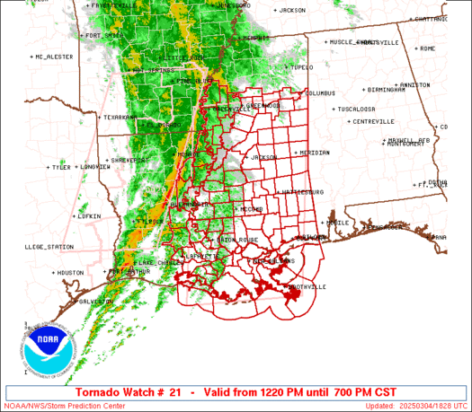
PDS for second day in a row. This one is basically maxed out:
TORNADO WATCH PROBABILITIES FOR WT 0021
NWS STORM PREDICTION CENTER NORMAN OK
1142 AM CST SUN JAN 22 2017
WT 0021 PDS
PROBABILITY TABLE:
PROB OF 2 OR MORE TORNADOES : 90%
PROB OF 1 OR MORE STRONG /F2-F5/ TORNADOES : 90%
PROB OF 10 OR MORE SEVERE WIND EVENTS : 90%
PROB OF 1 OR MORE WIND EVENTS >= 65 KNOTS : 90%
PROB OF 10 OR MORE SEVERE HAIL EVENTS : 90%
PROB OF 1 OR MORE HAIL EVENTS >= 2 INCHES : 90%
PROB OF 6 OR MORE COMBINED SEVERE HAIL/WIND EVENTS : >95%
TORNADO WATCH PROBABILITIES FOR WT 0021
NWS STORM PREDICTION CENTER NORMAN OK
1142 AM CST SUN JAN 22 2017
WT 0021 PDS
PROBABILITY TABLE:
PROB OF 2 OR MORE TORNADOES : 90%
PROB OF 1 OR MORE STRONG /F2-F5/ TORNADOES : 90%
PROB OF 10 OR MORE SEVERE WIND EVENTS : 90%
PROB OF 1 OR MORE WIND EVENTS >= 65 KNOTS : 90%
PROB OF 10 OR MORE SEVERE HAIL EVENTS : 90%
PROB OF 1 OR MORE HAIL EVENTS >= 2 INCHES : 90%
PROB OF 6 OR MORE COMBINED SEVERE HAIL/WIND EVENTS : >95%
Posted on 1/22/17 at 11:58 am to rds dc
Crazy, for the second time within a year a tornado has hit within a mile south of me. Luckily, no damage either time.
Edit: To be clear, I sustained no damage. Lots of downed trees south of me.
Edit: To be clear, I sustained no damage. Lots of downed trees south of me.
This post was edited on 1/22/17 at 12:10 pm

Posted on 1/22/17 at 11:59 am to rds dc
Wow on those probabilities!

Posted on 1/22/17 at 12:09 pm to Paul Allen
Tornado warning NW of Montgomery.

quote:
681
WFUS54 KBMX 221804
TORBMX
ALC001-221845-
/O.NEW.KBMX.TO.W.0011.170122T1804Z-170122T1845Z/
BULLETIN - EAS ACTIVATION REQUESTED
Tornado Warning
National Weather Service Birmingham AL
1204 PM CST SUN JAN 22 2017
The National Weather Service in Birmingham has issued a
* Tornado Warning for...
Northern Autauga County in Alabama...
* Until 1245 PM CST
* At 1203 PM CST, a severe thunderstorm capable of producing a
tornado was located over Mulberry, or 11 miles east of Valley
Grande, moving northeast at 30 mph.
HAZARD...Tornado.
SOURCE...Radar indicated rotation.
IMPACT...Flying debris will be dangerous to those caught without
shelter. Mobile homes will be damaged or destroyed.
Damage to roofs, windows, and vehicles will occur. Tree
damage is likely.
* Locations impacted include...
Deatsville, Billingsley, Vida Junction, Booth, Marbury, Mulberry
and New Prospect.
PRECAUTIONARY/PREPAREDNESS ACTIONS...
TAKE COVER NOW! Move to a basement or an interior room on the lowest
floor of a sturdy building. Avoid windows. If you are outdoors, in a
mobile home, or in a vehicle, move to the closest substantial shelter
and protect yourself from flying debris.
&&
LAT...LON 3242 8683 3243 8683 3251 8687 3271 8664
3271 8641 3257 8641 3240 8682
TIME...MOT...LOC 1803Z 233DEG 26KT 3248 8679
TORNADO...RADAR INDICATED
HAIL...<.75IN
$$

Posted on 1/22/17 at 12:13 pm to slackster
That warning near Montgomery seems a bit unique in that it appears to be the center of the low level circulation as well.
I don't know if that is rare or not, but usually you see these warning are far out in front of the overall system.
I don't know if that is rare or not, but usually you see these warning are far out in front of the overall system.


Posted on 1/22/17 at 12:21 pm to slackster
How many people have heard the roaring of a tornado IRL?
I'll never forget that sound, and it's so spooky when it's at night. Its like, fighting blind.
I'll never forget that sound, and it's so spooky when it's at night. Its like, fighting blind.

Posted on 1/22/17 at 12:25 pm to cubsfan5150
quote:
Crazy, for the second time within a year a tornado has hit within a mile south of me. Luckily, no damage either time.
Edit: To be clear, I sustained no damage. Lots of downed trees south of me.
Did you grow up in Valdosta? I grew up there and still have family there and in Nashville, GA. Sounds like things down there got a little crazy last night. Two of my grandfather's friends were killed when a tree fell on their house around 4am. Hope that area is spared this afternoon during the second round.
This post was edited on 1/22/17 at 12:26 pm
Posted on 1/22/17 at 12:25 pm to cubsfan5150
quote:
Crazy, for the second time within a year a tornado has hit within a mile south of me. Luckily, no damage either time.
Edit: To be clear, I sustained no damage. Lots of downed trees south of me.
FYI, if you're in Valdosta, GA, you're severe weather threat doesn't really diminish until 4-5pm local time. You're through the early day stuff but the afternoon stuff is still coming.


Posted on 1/22/17 at 12:31 pm to slackster
This spin up has been warned, but appears to be broadening over the last few minutes.

Posted on 1/22/17 at 12:39 pm to wareagle47
Any clue where they lived?
Posted on 1/22/17 at 12:41 pm to slackster
Good radar reading slackster. You're getting pretty good at seeing this stuff.
Posted on 1/22/17 at 12:42 pm to rds dc
Wow I don't recall seeing numbers so high on a watch since April 2011. That's some freaky high potency...prayers out to those affected already and who are in the watch area!
Posted on 1/22/17 at 12:46 pm to cubsfan5150
Lived just outside of Nashville. Not too far off of Adel Hwy.
Posted on 1/22/17 at 12:51 pm to Duke
Looks like 3 semi discrete supercells are about to move onshore around Mexico Beach


 Page 19 of 27

Popular
Back to top
 Follow TigerDroppings for LSU Football News