- My Forums
- Tiger Rant
- LSU Recruiting
- SEC Rant
- Saints Talk
- Pelicans Talk
- More Sports Board
- Fantasy Sports
- Golf Board
- Soccer Board
- O-T Lounge
- Tech Board
- Home/Garden Board
- Outdoor Board
- Health/Fitness Board
- Movie/TV Board
- Book Board
- Music Board
- Political Talk
- Money Talk
- Fark Board
- Gaming Board
- Travel Board
- Food/Drink Board
- Ticket Exchange
- TD Help Board
Customize My Forums- View All Forums
- Show Left Links
- Topic Sort Options
- Trending Topics
- Recent Topics
- Active Topics
Started By
Message
re: The Great Flood of 2016: Fill Out Disaster Forms NOW. Link Inside!
Posted on 8/14/16 at 10:09 pm to supernovasky

Posted on 8/14/16 at 10:09 pm to supernovasky
Anyone in Somersby off Antioch? How is the water level there?
 1
1

Posted on 8/14/16 at 10:10 pm to CENLALSUFAN
Posted on 8/14/16 at 10:10 pm to Paul Allen
quote:
Yeah, where is that info coming from?
I was there around 6 today. The water hasn't reached the manchac plantation entrance yet. There is a pretty good incline in the roadway there.

Posted on 8/14/16 at 10:10 pm to BeerMoney
Is Old Perkins and Old Jefferson behind Winn Dixie still underwater?
Posted on 8/14/16 at 10:10 pm to Paul Allen
Probably areas north of 42 along the bayou.
Posted on 8/14/16 at 10:10 pm to rt3
quote:
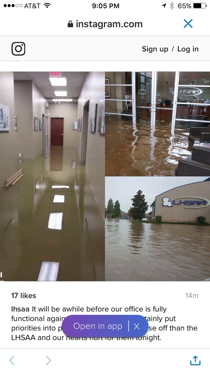
Louisiana Class 5A ?@Louisiana5A
Photos of @LHSAA offices in BR, they will be closed indefinitely
Posted on 8/14/16 at 10:10 pm to supernovasky
super, FWIW, at 6 pm this evening, drains were definitely overflowing at Lee and Highland. Streets were otherwise very dry. May have been discussed already, and not sure if still overflowing, but just FWIW. Also, thanks again for info last night - helped me prepare for recovery work this morning.
Posted on 8/14/16 at 10:10 pm to urinetrouble
Gotcha. I call that alligator bayou road.
Posted on 8/14/16 at 10:10 pm to DrEdgeLSU
quote:
The Great Flood of 2016: Backflow Flooding Occuring (8/14/16)
Is it expected that we may see backflow into Bayou Duplantier and Dawson Creek as Ward Creek rises? Are there flood gauges on those creeks? (We are in South Pollard backing up to Christian Life).
It is MENTIONED. Personally... I don't see nearly as much written about Ward Creek in most places concerning backwater flow, but it is technically in the same basin and should fill back with water just like Bayou Fountain. I am only more concerned about Bayou Fountain because it is closer to causing trouble.

Posted on 8/14/16 at 10:11 pm to Nado Jenkins83
Good question. I did see a post yesterday that it was already flooded though

Posted on 8/14/16 at 10:11 pm to supernovasky
Any way the back flow could reach the Lake Beau Pre complex? There's a drainage ditch along the southside that connects to Bayou Fountain. It's seems highly unlikely...
Posted on 8/14/16 at 10:11 pm to Droplinebacker
quote:
super, FWIW, at 6 pm this evening, drains were definitely overflowing at Lee and Highland. Streets were otherwise very dry. May have been discussed already, and not sure if still overflowing, but just FWIW. Also, thanks again for info last night - helped me prepare for recovery work this morning.
Thanks a ton, I am wondering if it is still happening.
Posted on 8/14/16 at 10:11 pm to Paul Allen
Have no clue which parts, they aren't saying..just a general voluntary evac

Posted on 8/14/16 at 10:11 pm to supernovasky
So you still feel the Jefferson Terrace/Inniswold area has some flooding ahead based on that?
Posted on 8/14/16 at 10:11 pm to Nado Jenkins83
quote:
Can bluebonnet swamp absorb any of the blow or is it not connected? Or full already?
If you look at the 100 year flood map the swamp floods at 15 feet. So does bayou manchac at I-10. As well as isolated areas of burbank and highland.
Other than that the further west you head on highland the required heights of water start going up and up. Burbank and lee floods at like 20 feet.
There is no way water is getting to that area if the water at I-10 and manchac is relatively stable.
Do you agree supernovasky?

Posted on 8/14/16 at 10:11 pm to Schmelly
Posted on 8/14/16 at 10:12 pm to BigEdLSU
I got pics of the issue but no clue how to post them.. Can someone tell me best way to post?
Posted on 8/14/16 at 10:12 pm to Teauxler
Had friends got stranded for 26 hours on the overpass at Holden exit. They were on the way to Destin on vacation.
Does it look like they will be able to get back to their car and get on the road tomorrow ?
-----------------------------------------------------------
I had a friend stuck at the Holden exit also. They opened the road sometime this afternoon and he's back home in Jackson now.
If your friend was eastbound, and in the same area near the Holden exit, he should have been moving several hours ago.
Posted on 8/14/16 at 10:12 pm to lovelsu
quote:
A little bit of hope for some - I caught part of JBE on WBRZ and he stated that those that do not have flood insurance because they are in an area that did not require insurance due to the flood maps will be eligible for assistance from FEMA. He said it was limited and individual max would be $30,000 (with proof of $$damage). I don't have a link but wanted to pass it on as I hope this will help a little. He stated you need to register with FEMA but that is all I heard as I had walked out of the room.
So , will I be able to put a claim in for reimbursement of the multiple years worth of premiums I have paid ?

Posted on 8/14/16 at 10:13 pm to Clark W Griswold
quote:
Anyone in Somersby off Antioch? How is the water level there?
I don't know about Somersby directly, but that area of Tiger Bend and everything to the South was underwater. Tiger Bend at Antioch was like 6-8 feet deep.

 Page 282 of 472

Popular
Back to top