- My Forums
- Tiger Rant
- LSU Recruiting
- SEC Rant
- Saints Talk
- Pelicans Talk
- More Sports Board
- Fantasy Sports
- Golf Board
- Soccer Board
- O-T Lounge
- Tech Board
- Home/Garden Board
- Outdoor Board
- Health/Fitness Board
- Movie/TV Board
- Book Board
- Music Board
- Political Talk
- Money Talk
- Fark Board
- Gaming Board
- Travel Board
- Food/Drink Board
- Ticket Exchange
- TD Help Board
Customize My Forums- View All Forums
- Show Left Links
- Topic Sort Options
- Trending Topics
- Recent Topics
- Active Topics
Started By
Message
 2
2


Posted on 8/14/16 at 12:27 am to Teauxler
Prob 50 or so friends and family lost their houses and cars today. Unreal. That much water so quickly. Most are under 6 feet + of water.

Posted on 8/14/16 at 12:27 am to Catman88
What's important is the wavy line at 46 and your actual slab elevation, if known (and of course the datum). Then the question is: is the flood above or below that magic 46 number?
Posted on 8/14/16 at 12:27 am to slackster
quote:
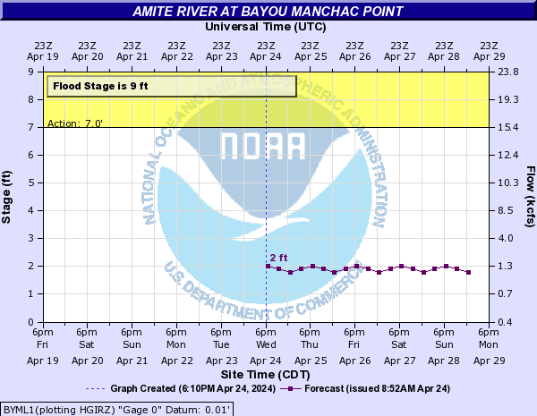
The Amite River at Bayou Manchac is projected to crest at noon on Monday.
what does this mean for the santa maria area/old perkins area?
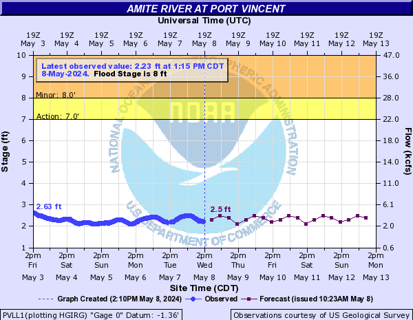
Posted on 8/14/16 at 12:27 am to Carville
quote:
Thanks, I'm about two miles from Port Vincent.
Here is the projection (pretty sure this auto-updates like most NWS graphics) :

Posted on 8/14/16 at 12:28 am to member12
It's about 1/4 of the way up the yards on the corner and rising about 4 inches an hour
Posted on 8/14/16 at 12:28 am to member12
I'd doubt it, but I could be wrong
It could be very close
It could be very close
Posted on 8/14/16 at 12:28 am to doubleb
quote:
Water just starting to flow out ofClaycut Bayou onto Cloverland in Industriplex
shite this is moving fast. Claycut is apparently backflowing now too. I thought it would be another hour or two.
This post was edited on 8/14/16 at 12:29 am
Posted on 8/14/16 at 12:29 am to UNO
That's when things will be the worst

Posted on 8/14/16 at 12:29 am to The Boat
I'm going take a look at that area.
Posted on 8/14/16 at 12:29 am to UNO
quote:Bayou Manchac and Ward's Creek will likely rise to the 21.5 elevation that's forecasted in the Amite crest.
what does this mean for the santa maria area/old perkins area?
Posted on 8/14/16 at 12:30 am to doubleb
quote:
That's when things will be the worst
is there any way to gauge how high the water will get there?
sorry, i'm not good at this.
Posted on 8/14/16 at 12:30 am to UNO
quote:
what does this mean for the santa maria area/old perkins area?
There likely will be flooding around the golf course judging from the flood maps.
Posted on 8/14/16 at 12:30 am to tke857
Anyone know the closest motel to Jefferson/Stumberg? I want to send my cousins somewhere they can get to and be certain that it won't flood and thatthey can come back to Stumberg in the morning to check their things. Thanks.
Posted on 8/14/16 at 12:30 am to LSUJuice
quote:
ayou Manchac and Ward's Creek will likely rise to the 21.5 elevation that's forecasted in the Amite crest.
okay, so if your house is above the 21.5 level, it should be okay around monday at that time?
Posted on 8/14/16 at 12:31 am to UNO
quote:
what does this mean for the santa maria area/old perkins area?
From the NWS reference flood stage descriptions...
quote:
16 feet Homes along Highland Road and Burbank Drive will be flooded. Both streets will be impassable. Major roads will be impassable. Access to property along the river is cut off. Homes along Kendalwood Road that are not elevated will be flooded. Extensive backwater flooding will occur along Bayou Fountain and Bayou Manchac.
15 Major roads will be impassable. Access to property along the river is cut off. Homes along Kendalwood Road that are not elevated will be flooded. Extensive backwater flooding will occur along Bayou Fountain and Bayou Manchac.
14 Backwater flooding along Bayou Manchac and Bayou Fountain will flood Highland Road and Burbank Drive in places. Many homes will be threatened along the bayous from their Amite River outlets upstream to the LSU campus. Kendalwood Road and adjacent property will be inundated. Amite River Road and Horseshoe Drive will remain impassable.
12 Kendalwood Road and adjacent property will be inundated. Backwater may flood Bayou Fountain and flood some homes on Burbank Drive. Most secondary roads will be moderately flooded. Amite River Road and Horseshoe Drive will be impassable. A few homes on Horseshoe Drive will flood.
10 Amite River Road and Horseshoe Drive will be impassable. A few homes on Horseshoe Drive will flood. Water will be approaching Kendalwood Road and access to property will be threatened.
9 The river will begin to flood property along Bayou Manchac and the Amite River. Amite River Road and Horseshoe Drive will be flooded
Posted on 8/14/16 at 12:31 am to LSUJuice
If I flood I flood. I just have my wife and son sleeping and wish I knew if I could sleep tonight or have to stay up watching. I might need the rest if I have to make a move tomorrow. Of course I would just load them in the bay boat and untie from trailer and hope I don't actually go anywhere.
This post was edited on 8/14/16 at 12:32 am
Posted on 8/14/16 at 12:31 am to LSUJuice
quote:
Bayou Manchac and Ward's Creek will likely rise to the 21.5 elevation that's forecasted in the Amite crest.
If you are right, things will be bad for Santa Maria, CCLA, Spring Lake, and Fairhill (and Gardere and eventually south campus).

Posted on 8/14/16 at 12:31 am to LSUJuice
(no message)
This post was edited on 12/21/16 at 7:11 pm
Posted on 8/14/16 at 12:31 am to LSUJuice
quote:
Bayou Manchac and Ward's Creek will likely rise to the 21.5 elevation that's forecasted in the Amite crest.
Does that mean that the level in the Amite crest would be lower than the 21.5 projected because the water would be dispersed upstream in a backwater situation? Or am I off base?

 Page 123 of 472

Popular
Back to top