- My Forums
- Tiger Rant
- LSU Recruiting
- SEC Rant
- Saints Talk
- Pelicans Talk
- More Sports Board
- Fantasy Sports
- Golf Board
- Soccer Board
- O-T Lounge
- Tech Board
- Home/Garden Board
- Outdoor Board
- Health/Fitness Board
- Movie/TV Board
- Book Board
- Music Board
- Political Talk
- Money Talk
- Fark Board
- Gaming Board
- Travel Board
- Food/Drink Board
- Ticket Exchange
- TD Help Board
Customize My Forums- View All Forums
- Show Left Links
- Topic Sort Options
- Trending Topics
- Recent Topics
- Active Topics
Started By
Message
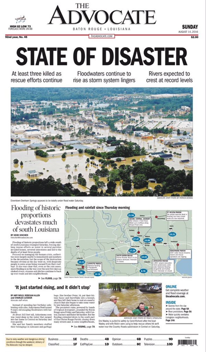
re: The Great Flood of 2016: Fill Out Disaster Forms NOW. Link Inside!
Posted on 8/13/16 at 11:44 pm to Festus
Posted on 8/13/16 at 11:44 pm to Festus
quote:
Shenandoah avenue is street I live on.
LINK
40' sounds about right for that area according to this map. I imagine that the top of your finished slab is built up a foot or so higher (perhaps more).
 1
1


Posted on 8/13/16 at 11:45 pm to supernovasky
quote:
Scanner just said they're moving in to close Millerville @Avalon/Breton because of high water coming over the roadway now.
so just to be clear, water is coming over Millerville?

Posted on 8/13/16 at 11:45 pm to LouisianaLady
I'm worried about the horses in prairieville. 30 some locked in the barn for the night. No real waterway in the area but there is a creek that flooded the pastures at about 4.
Posted on 8/13/16 at 11:46 pm to LouisianaLady
I'm not far from Tommy's Fish House and we're OK for now.
Posted on 8/13/16 at 11:46 pm to LouisianaLady
quote:
Goddamnit I don't know that area and my brother is being completely unhelpful and that's where he is.
Will not give me an address for fricking anything. Near "Tommy's Fish House" and Airline if that means anything. I know absolutely zero about that area.
They are very close to the Prairieville Wal Mart. Look for Old Perkins and Airline.

Posted on 8/13/16 at 11:46 pm to Catman88
quote:
They are talking pleasant ridge Rd in walker
Dawson Creek is not the Pleasant Ridge in Walker. I told them where I live. They are responding to me.
Believe me, I had a mini heart attack earlier when they were talking about Pleasant Rdige in Walker already
This post was edited on 8/13/16 at 11:47 pm
Posted on 8/13/16 at 11:46 pm to member12
Wait are yall talking about a different Pleasant Ridge? I'm talking about the one in Walker behind Auto Zone.
Posted on 8/13/16 at 11:46 pm to LouisianaLady
quote:
I am not there. But I am going to try to get there and put them inside. I have to drive there from Highland/Lee. My place is two story, so we'd have to experience an apocalypse for them to not be safe indoors.
It is a matter of finding them though.
Be safe. Your cats will probably find higher ground on their own.
I'm not sure when the back flow into Dawson Creek will start right there. Watch the gauges on the river.
Posted on 8/13/16 at 11:47 pm to terd ferguson
There are two Pleasant Ridges. I originally didn't say the name of my place on purpose because I knew y'all were talking about Walker.
This post was edited on 8/13/16 at 11:48 pm
Posted on 8/13/16 at 11:47 pm to LaBR4
quote:
so just to be clear, water is coming over Millerville?
I'm thinking they mean more of that intersection coming from Old Hammond. I don't know that area terribly well and they weren't specific. Hopefully someone who knows this area better can hopefully give the most likely scenario.
Posted on 8/13/16 at 11:47 pm to LouisianaLady
Is water crossing hoo shoo too rd by bayou manchac close to Elliot?
Posted on 8/13/16 at 11:48 pm to ihometiger
My apologies, if this has been posted already. Been traveling all day and gotten nothing but bad news...
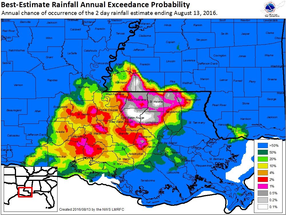
Tomorrow's Advocate:
White areas have a 0.1% of occurring in any one year aka 1,000 "year" flood:
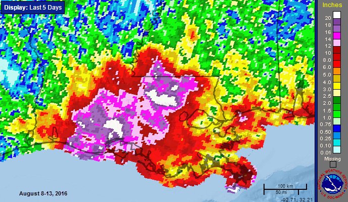
As of now, it looks like 31" was the top total beating the Spring '16 totals and Alison from 2001:

Tomorrow's Advocate:
White areas have a 0.1% of occurring in any one year aka 1,000 "year" flood:
As of now, it looks like 31" was the top total beating the Spring '16 totals and Alison from 2001:
Posted on 8/13/16 at 11:49 pm to TigersSEC2010
quote:
I'm thinking they mean more of that intersection coming from Old Hammond. I don't know that area terribly well and they weren't specific. Hopefully someone who knows this area better can hopefully give the most likely scenario.
I gotcha, damn, if it's gotten to that Chili's, Target, and Chick-fil-A already...
This post was edited on 8/13/16 at 11:52 pm
Posted on 8/13/16 at 11:49 pm to member12
I'm 5min away. Can park at the front where it is exponentially higher.
Posted on 8/13/16 at 11:49 pm to TigersSEC2010
quote:
I'm thinking they mean more of that intersection coming from Old Hammond. I don't know that area terribly well and they weren't specific. Hopefully someone who knows this area better can hopefully give the most likely scenario.
hard to interpret from the police scanner. Millerville runs downhill to old Hammond from Avalon, so it makes sense that they'd close it at Avalon.

Posted on 8/13/16 at 11:49 pm to tke857
Okay, I am looking at these maps and I'm a little worried about my sister and her family. They are zone X but are, to me, uncomfortably close to the blue. She lives in an apartment complex just north of Jefferson Highway between Stumburg Lane and Morning Dove Drive...I can't remember the name of the complex. Everything south of her is blue. I might do it anyway, but should I advise her that she should prepare a bug-out bag and be ready to move?
This post was edited on 8/13/16 at 11:50 pm

Posted on 8/13/16 at 11:50 pm to LouisianaLady
LL, is your condo in Pleasant Ridge really in danger?
Posted on 8/13/16 at 11:50 pm to LouisianaLady
quote:
Will not give me an address for fricking anything. Near "Tommy's Fish House" and Airline if that means anything. I know absolutely zero about that area.
Looks like the elevation at tommys is around 22.5. Manchac is supposed to crest around 21.5. It's going to be close with only a foot of play to account for back flooding
Posted on 8/13/16 at 11:51 pm to Tino
quote:
Terd, have you heard anything about the main drag in Walker? Any businesses underwater?
I haven't heard about anything in Walker. My parents went out of town yesterday and I told them to not even try coming back today. I'm pretty much stuck between Holden and Albany so I haven't been able to check on their house.
They were checking their security cameras earlier but last I heard the cameras were down. Guessing that the power went out.

Posted on 8/13/16 at 11:52 pm to TigersSEC2010
quote:
Scanner just said they're moving in to close Millerville @Avalon/Breton because of high water coming over the roadway now.
Just got through walking that area (I live near there). Honey Cut Bayou is inches from the bottom of the bridge.
The storm drains there go to the Amite and have backed up well across the road from north of the bayou until just south of Maple Ridge (Avalon subdivision). We're in Fairwood Estates and watching our drains back up onto our roads (they empty into Jones Creek).

 Page 117 of 472

Popular
Back to top