- My Forums
- Tiger Rant
- LSU Recruiting
- SEC Rant
- Saints Talk
- Pelicans Talk
- More Sports Board
- Fantasy Sports
- Golf Board
- Soccer Board
- O-T Lounge
- Tech Board
- Home/Garden Board
- Outdoor Board
- Health/Fitness Board
- Movie/TV Board
- Book Board
- Music Board
- Political Talk
- Money Talk
- Fark Board
- Gaming Board
- Travel Board
- Food/Drink Board
- Ticket Exchange
- TD Help Board
Customize My Forums- View All Forums
- Show Left Links
- Topic Sort Options
- Trending Topics
- Recent Topics
- Active Topics
Started By
Message
re: Storm Update:- Ida Moves Away - The Cleanup Begins...
Posted on 8/29/21 at 11:10 am to lionward2014
Posted on 8/29/21 at 11:10 am to lionward2014
quote:
Live about 3 blocks from Kingpin.
Not to give anyone a bingo, but I got you area covered.
 0
0


Posted on 8/29/21 at 11:10 am to Crow Pie
quote:
Is the storm sill expected to track to the northeast after landfall?
The forecasted track is always on the first post of this thread.
You can view it anytime you like.
Posted on 8/29/21 at 11:10 am to Motorboat
Water rose a foot instantly on the GI camera just now
WOW
WOW

Posted on 8/29/21 at 11:10 am to Triple Bogey
quote:
How is that GI camera still live?
Wind powered, obviously
Posted on 8/29/21 at 11:10 am to The Boat
(no message)
This post was edited on 10/18/21 at 11:19 pm
Posted on 8/29/21 at 11:10 am to deltaland
quote:
Will any storm chaser today top Brett Adair in hurricane Michael?
No
Posted on 8/29/21 at 11:10 am to The Boat
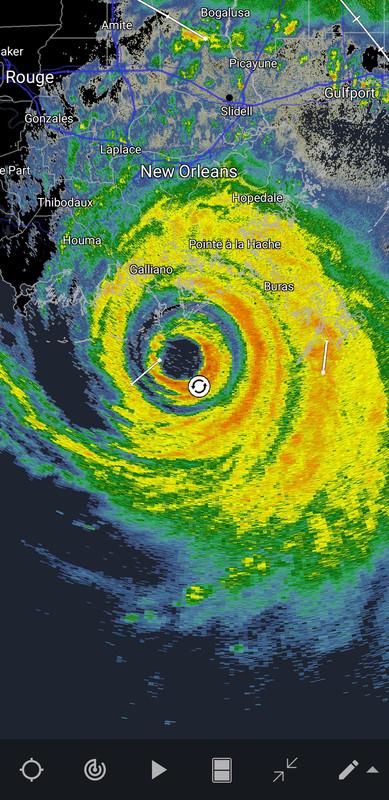
That's a damn impressive double eyewall.

Posted on 8/29/21 at 11:11 am to Motorboat
Grand Isle cam is about to get into the eastern eye wall which is why it's escalating so quickly

Posted on 8/29/21 at 11:11 am to LegendInMyMind
How long until it hits BR?
Posted on 8/29/21 at 11:11 am to Triple Bogey
quote:
Reports of 146mph gusts in Grand Isle about 10-15mi outside the inner eyewall where the strongest winds are likely hiding. Official NHC estimates indicate the inner eyewall moving over Port Fourchon is likely producing 150mph sustained winds with gusts as high as 185mph.
LINK
Posted on 8/29/21 at 11:11 am to Caymus
Police in Grand Isle clocked 148 mph before the anemometer left.

Posted on 8/29/21 at 11:11 am to LegendInMyMind

Posted on 8/29/21 at 11:11 am to LegendInMyMind
Concentric eyewalls at landfall...crazy!!

Posted on 8/29/21 at 11:12 am to lsutiger2010
Yeah I think I saw a stop sign earlier. That tree is one strong mofo though

Posted on 8/29/21 at 11:12 am to Greace
quote:
likely producing 150mph sustained winds with gusts as high as 185mph.
Holy shite
Posted on 8/29/21 at 11:12 am to Caymus
quote:
Water rose a foot instantly on the GI camera just now
WOW
Yall watch this and see just how fast surge happens.
Posted on 8/29/21 at 11:12 am to deltaland
quote:
The damage from this storm is going to be heart wrenching
Mom’s house is on the terrebonne / lafourche line not expecting much to be left. Hoping to be able to get down there with chainsaws and a grapple in the next few days. It’s gonna be on a once in a generation scale for many parts.

Posted on 8/29/21 at 11:12 am to lsutiger2010
quote:That's paw paw's camp
but there are LARGE pieces of debris just floating by on that GI cam.
Posted on 8/29/21 at 11:13 am to tgrbaitn08
Levee broke maybe?
Missed where she said that was
Missed where she said that was

Posted on 8/29/21 at 11:13 am to rds dc
I hate to see this. My hometown of St. Charles Parish is about to take a beating. shite.

 Page 687 of 1029

Popular
Back to top