




- My Forums
- Tiger Rant
- LSU Recruiting
- SEC Rant
- Saints Talk
- Pelicans Talk
- More Sports Board
- Fantasy Sports
- Golf Board
- Soccer Board
- O-T Lounge
- Tech Board
- Home/Garden Board
- Outdoor Board
- Health/Fitness Board
- Movie/TV Board
- Book Board
- Music Board
- Political Talk
- Money Talk
- Fark Board
- Gaming Board
- Travel Board
- Food/Drink Board
- Ticket Exchange
- TD Help Board
Customize My Forums- View All Forums
- Show Left Links
- Topic Sort Options
- Trending Topics
- Recent Topics
- Active Topics
Started By
Message

 1
1


Posted on 7/22/26 at 11:01 pm to lsumailman61
ya our barrier islands always take a beating sadly

Posted on 7/22/26 at 11:46 pm to Chicken
I use the myradar app me.
Posted on 7/23/26 at 12:49 am to tigersownall
Me too. Great app to have
60mph gust on East Cameron oil platform
51mph @ Ship Shoal
Bertha's BLOB is Flexing down in the Northern Gulf

60mph gust on East Cameron oil platform
51mph @ Ship Shoal
Bertha's BLOB is Flexing down in the Northern Gulf
This post was edited on 7/23/26 at 12:56 am

Posted on 7/23/26 at 2:42 am to tigercraig
quote:
That is infared satellite not radar
Infrared only shows the coldest cloud tops. This storm did not show itself compared to the visible in that the visible had the well defined center exposed with very thin clouds. Center looked neat from the Ground when it passed in Galliano. Nice clear deep blue sky.
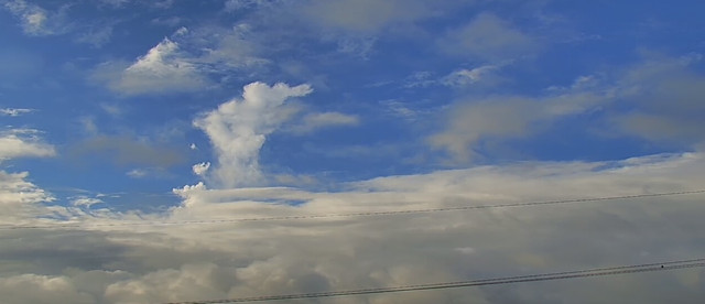
I can remember for Zeta when the center passed over the same area around sunset you had a nice deep pinkish hue to the sky.
Posted on 7/23/26 at 6:11 am to Tarps99
It’s frustrating how most apps don’t show you precipitation if it’s from a named storm.
Is there an app I can use that won’t make me pay extra to see precipitation forecasts due to a named storm?
Is there an app I can use that won’t make me pay extra to see precipitation forecasts due to a named storm?


Posted on 7/23/26 at 6:51 am to roguetiger15
Is there any chance of this thing becoming more vertically aligned again or reforming under the thunderstorms? This AM 's discussion talking about a thunderstorm with a mesocyclone near the mid level center.
I know theres a lot of shear but that blob is impressive.
I know theres a lot of shear but that blob is impressive.
Posted on 7/23/26 at 6:57 am to antibarner
Doubt it. The pressure, shear, location. Nothing suggests this has a chance at real development.


Posted on 7/23/26 at 7:11 am to antibarner
No, the low level center is absolutely cooked

Posted on 7/23/26 at 8:24 am to roguetiger15
Does Windy not provide it? I am a paid member, but I thought the precip was on the free version.

Posted on 7/23/26 at 8:49 am to The Boat
Has a tropical system ever made landfall in the state and not a single drop of rain exist 16 hours later in the state

Posted on 7/23/26 at 9:12 am to Chad504boy
One of the oddest little storms I’ve seen in the 30 years I’ve lived in the zone.
Posted on 7/23/26 at 9:35 am to TROLA
quote:
One of the oddest little storms I’ve seen in the 30 years I’ve lived in the zone.
Yep.
I can remember another odd storm from the 1990's. I think it was Hurricane Danny. This one formed the Southwestern gulf and moved to the Northeast. The eye wall made a jog over Grand Isle strengthened to a hurricane while partially on land headed to Alabama and Florida. It was small and compact. I did not feel much in Cut Off.
Back then there was really no breakneck coverage of Tropical Storms besides just a few news bulletins at the every 3 hour intervals of the NHC new plot. Now they did dedicate a few more minutes of coverage during the news, but that was the extent of it.
I do remember seeing a relative of mine on the news who decided to stay for the storm in a rickety camp in Camanada. She talked about how her house was moving up and down.
Posted on 7/23/26 at 9:57 am to Chicken
quote:
I just that I noticed red over Houston today in the OP radar and there was nothing in the skies...
Thank capitalism. These news and weather stations survive on views. Over time big corporations have found that the best way to get views is to scare people or sex. Mexico went the sex way. America decided to scare people.
Houston has a lot of people.
That’s why I only watch Mexican weather channels.

Posted on 7/23/26 at 10:42 am to CrazyTigerFan
Hey guys, getting ready to fly into Houston and drive into BR this evening?
How are things looking over there on the ground.
How are things looking over there on the ground.

Posted on 7/23/26 at 10:57 am to RBTiger
Looks like the stuff popping up over the Carolinas and Georgia are part of this? Or being influenced by it?
Posted on 7/23/26 at 11:01 am to Chucktown_Badger
Rain band popping in Covington out the blue
Posted on 7/23/26 at 11:12 am to Chad504boy
quote:
Rain band popping in Covington out the blue
It is summer time in SE Louisiana.
That shower could come from typical daytime heating or from the sea breeze.
This post was edited on 7/23/26 at 11:15 am
Posted on 7/23/26 at 11:12 am to bigpetedatiga
quote:
Hey guys, getting ready to fly into Houston and drive into BR this evening?
How are things looking over there on the ground.
It’s a completely normal day.
Posted on 7/23/26 at 11:13 am to Tarps99
sure but its clearly outer bands heating up from heat from the storm tracking north.

 Page 37 of 38

Popular
Back to top
 Follow TigerDroppings for LSU Football News