- My Forums
- Tiger Rant
- LSU Recruiting
- SEC Rant
- Saints Talk
- Pelicans Talk
- More Sports Board
- Fantasy Sports
- Golf Board
- Soccer Board
- O-T Lounge
- Tech Board
- Home/Garden Board
- Outdoor Board
- Health/Fitness Board
- Movie/TV Board
- Book Board
- Music Board
- Political Talk
- Money Talk
- Fark Board
- Gaming Board
- Travel Board
- Food/Drink Board
- Ticket Exchange
- TD Help Board
Customize My Forums- View All Forums
- Show Left Links
- Topic Sort Options
- Trending Topics
- Recent Topics
- Active Topics
Started By
Message
re: Storm Aftermath - Hurricane Matthew will be Retired
Posted on 10/6/16 at 9:23 am to SohCahToa
Posted on 10/6/16 at 9:23 am to SohCahToa
quote:
I get it, but these models have been absolutely terrible at nailing down intensity lately. Someone can correct me if I'm wrong. I wouldn't panic, but its at least something to keep a close eye on.
As of now, all models, including individual ensemble members, that get this in the Gulf keep it weak.
 1
1

Posted on 10/6/16 at 9:23 am to ForeverLSU02
quote:
All models have it as a very weak system if it does loop into GOM.
Kinda like the one that dumped 30" of rain here just a month ago? Don't fool yourself into thinking it won't do any harm.

Posted on 10/6/16 at 9:24 am to rds dc
Thanks. For some unknown reason they listen to you 


Posted on 10/6/16 at 9:24 am to Hangit
quote:
Hangit
Sorry... Maybe it will bounce back to the east instead. Hang in there. The ride might get a little bumpy.
Posted on 10/6/16 at 9:24 am to shawnlsu
Burst of very intense convection in the northern eye wall

Posted on 10/6/16 at 9:25 am to shawnlsu
Nobody is discounting anything, he was only stating that the next 36 hours are the focus, not the next week.
Posted on 10/6/16 at 9:25 am to rds dc
Looks like it's headed straight for Port Saint Lucie?
Posted on 10/6/16 at 9:25 am to ForeverLSU02
quote:
I guess people don't understand what "right now" means
what does "right now" mean, if you are looking at a model you are looking at something in the future, not something happening "right now" and models show the near future, can be anything from 30 minutes from now to 10 days or more from "right now" and "right now" some models do have this storm coming into the GOM
if you meant something else, fine, but dont blame me for your poor choice of words
Posted on 10/6/16 at 9:26 am to shawnlsu
quote:
Kinda like the one that dumped 30" of rain here just a month ago? Don't fool yourself into thinking it won't do any harm.
The one that was projected to be a monster rain event? The point is that there is NO indication this will be much of anything in 5 days. That can certainly change, but we'll deal with it when/if that happens.
Posted on 10/6/16 at 9:28 am to Tigerpaw123
quote:
what does "right now" mean, if you are looking at a model you are looking at something in the future, not something happening "right now" and models show the near future, can be anything from 30 minutes from now to 10 days or more from "right now" and "right now" some models do have this storm coming into the GOM
Right now, the only reason the models are showing it coming to the Gulf is to spite a certain poster and ensure that his record of being wrong lives on
Posted on 10/6/16 at 9:29 am to HubbaBubba
quote:
owned a place a half block off the ocean on Sailfish Lane in Ocean Ridge right by Boynton Beach
My place isn't that far from where you were. We're right on the intracoastal just north of Boynton Beach blvd. the mangroves should hopefully keep some of those trees secure.

Posted on 10/6/16 at 9:30 am to rds dc
quote:
Burst of very intense convection in the northern eye wall
What's the significance?
Posted on 10/6/16 at 9:31 am to rds dc
quote:
rds dc
It looks like Matthew is literally going to ride the gulf stream current all the way up the coast until the projected swing east into the loop.
How much of an effect do you think that'll have on its strengthening?
Posted on 10/6/16 at 9:32 am to Tigerpaw123
I meant the GOM should not be affected by this first pass prior to it looping. The poster I responded to sounded concerned that Matthew could hop over Florida and into the GOM instead of going up the coast. At least that's what I gathered
Posted on 10/6/16 at 9:34 am to Clint Torres
Think of a hurricane as a big engine that turns heat into wind.
Deep convection means it's cooling the shite out of that warm water vapor. Higher the clouds, colder the temps. Providing more energy to transform into wind.
Very basically.
Deep convection means it's cooling the shite out of that warm water vapor. Higher the clouds, colder the temps. Providing more energy to transform into wind.
Very basically.
Posted on 10/6/16 at 9:34 am to ForeverLSU02
Population density shows why this is such a bad track for a system to take

Posted on 10/6/16 at 9:36 am to rds dc
At least Miami may be spared from the worst. That the only bit of optimism I can really take from that
Posted on 10/6/16 at 9:37 am to ForeverLSU02
@NationalGuard Twitter
Photo of the Day: As residents evacuate, the @FLGuard drives in to respond to #HurricaneMatthew. Always Ready, Always There!
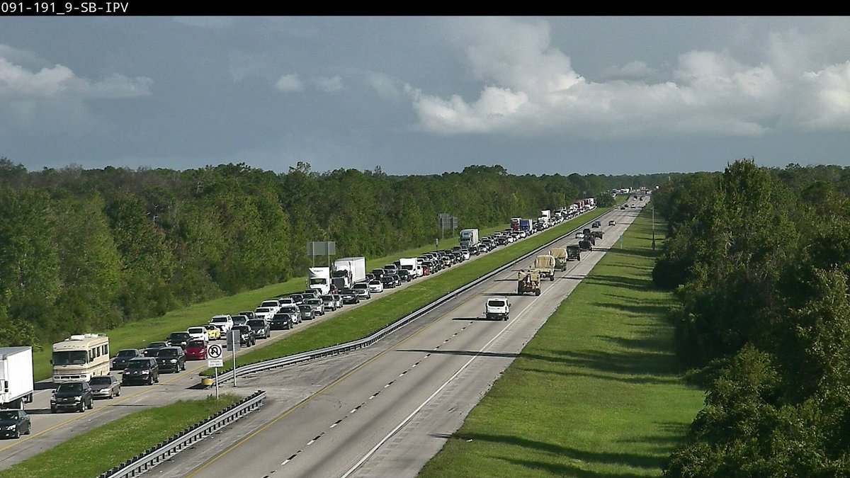
LINK
Photo of the Day: As residents evacuate, the @FLGuard drives in to respond to #HurricaneMatthew. Always Ready, Always There!
LINK
Posted on 10/6/16 at 9:37 am to Duke
The HRRR is having issues with the pressure forecast, but this is where it has it coming on shore as of now. This model is similar to what your local stations use for traditional severe weather projections.

Posted on 10/6/16 at 9:37 am to LosLobos111
quote:
Here you go
Yeah, i am in Zone A (red), but still watching. The latest track seems to be a lot more inland. Maybe that weakens it...

 Page 125 of 181

Popular
Back to top