- My Forums
- Tiger Rant
- LSU Recruiting
- SEC Rant
- Saints Talk
- Pelicans Talk
- More Sports Board
- Fantasy Sports
- Golf Board
- Soccer Board
- O-T Lounge
- Tech Board
- Home/Garden Board
- Outdoor Board
- Health/Fitness Board
- Movie/TV Board
- Book Board
- Music Board
- Political Talk
- Money Talk
- Fark Board
- Gaming Board
- Travel Board
- Food/Drink Board
- Ticket Exchange
- TD Help Board
Customize My Forums- View All Forums
- Show Left Links
- Topic Sort Options
- Trending Topics
- Recent Topics
- Active Topics
Started By
Message
re: Storm Aftermath - Hurricane Matthew will be Retired
Posted on 10/6/16 at 8:53 am to jimbeam

Posted on 10/6/16 at 8:53 am to jimbeam
Where are you reading that? No model has it going into the GOM right now
ETA: Right now meaning on the original pass in the next 2-3 days
ETA: Right now meaning on the original pass in the next 2-3 days
This post was edited on 10/6/16 at 9:17 am
 1
1

Posted on 10/6/16 at 8:53 am to LSU1NSEC
It's dropped about 20 mb since last night. Pretty quick deepening by any standard.
Outflow is really ventilating. Eyewall not about to replace via radar. Not looking good for our space coast bros.
Outflow is really ventilating. Eyewall not about to replace via radar. Not looking good for our space coast bros.
Posted on 10/6/16 at 8:53 am to Y.A. Tittle
quote:
Just because it will probably have a bit less wind, doesn't mean it won't be "anything worry about."
Exactly. There's going to be a ton of damage tonight/tomorrow. Power will be out, roads will be blocked, and massive repairs will be needed. No way those repairs can happen in six days while assuming supplies can be delivered. For instance, we're expecting to lose our roof. No way I can replace a roof and clean up the resulting flood damage in six days before it comes back to dump more rain. That would render my entire property a complete loss.
Posted on 10/6/16 at 8:54 am to slackster
quote:
I mean this thing is sitting over incredibly warm waters the rest of the way no matter what.
I saw a chart saying mostly 85-86 degrees. Is this considered warm and conducive to strengthening?
Posted on 10/6/16 at 8:56 am to Hangit


Posted on 10/6/16 at 8:57 am to ForeverLSU02
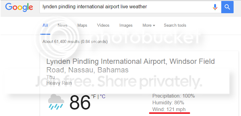
Here's a link to somewhat live updates from Nassau if anyone is interested: LINK
Posted on 10/6/16 at 8:58 am to ForeverLSU02
Explain this graph a bit more, please.
Is it just stating the areas that a storm could form?
Is it just stating the areas that a storm could form?
Posted on 10/6/16 at 8:59 am to bluemoons
Posted on 10/6/16 at 9:00 am to ThatMakesSense
Read the key at the bottom of it, its just showing areas where development is favorable. For the near future, Matthew is in highly favorable waters for development
Posted on 10/6/16 at 9:01 am to Y.A. Tittle
quote:
Usually, after a hurricane passes through, you have a good number of days of clear dry air to clean up. At best, if this thing does the loop they are predicting, it's going to pass through as a terrible storm, then three days later or so, come in and dump a ton of rain on top of them. Just because it will probably have a bit less wind, doesn't mean it won't be "anything worry about."
Sounds awful to me.
I know what you mean, but the current projections from the GFS don't suggest it will have much moisture with it when it crosses back after the loop. I wasn't simply dismissing it out of
hand because of a lack of wind.

Posted on 10/6/16 at 9:02 am to crazycubes
Bright side here is the humidity could be higher!
This post was edited on 10/6/16 at 9:03 am

Posted on 10/6/16 at 9:02 am to Hangit
85 is about top of the mark in terms of strengthening
Posted on 10/6/16 at 9:03 am to RATeamWannabe
I get that part of it.
Guess a better question would be, TD and hurricanes, don't normally form 50 miles off the gulf coast, yes or no?
Unless I just don't pay much attention until someone says I should GTFO and evacuate, I've always thought there has been days advanced warning, meaning the storms normally form far offshore.
Posted on 10/6/16 at 9:06 am to PurpGold 14-0
quote:
Too far off to say. It's going to come back and hit Florida again, likely as a category 1 or strong tropical storm on the second pass. What it does from there is still to be determined.
Fwiw none of the models suggest it will be a tropical storm at that point, much less a hurricane. We'll see as things move forward though obviously.
Posted on 10/6/16 at 9:06 am to Duke
quote:
Eyewall not about to replace via radar. Not looking good for our space coast bros.
I know they say eyewall replacement cycles are hard to predict, but do they happen with any regularity? For example, odds of one occuring before mid-day tomorrow?
Posted on 10/6/16 at 9:07 am to NorthEndZone
quote:
Matthew's wind field is forecast to spread outward as he travels up the coast as shown in the NHC forecast below.
I recall that in the 24-36 hours before Katrina, the wind field really exploded... with hurricane winds pushing out much further and TS winds as well.
Is this common as major hurricanes approach a large coastline?
Posted on 10/6/16 at 9:09 am to ForeverLSU02
quote:
Where are you reading that? No model has it going into the GOM right now
5-6 models have it coming into the GOM

Posted on 10/6/16 at 9:09 am to LSUFanHouston
quote:
For example, odds of one occuring before mid-day tomorrow?
Odds are good, but the more cycles it has the larger the wind field grows, all else being equal. Ideally you would want it to strike during a cycle, but the act of cycling doesn't mean it will be weaker in 18 hours.
Posted on 10/6/16 at 9:12 am to crazycubes
Last fall we took a cruise and spent the day at the British Colonial Hilton which is about 10 miles from the airport. This is crazy.
Posted on 10/6/16 at 9:12 am to Tigerpaw123
quote:I realize that. I was talking about right now. I'm not too concerned with what it does after looping back. All models have it as a very weak system if it does loop into GOM.
5-6 models have it coming into the GOM

 Page 123 of 181

Popular
Back to top