- My Forums
- Tiger Rant
- LSU Recruiting
- SEC Rant
- Saints Talk
- Pelicans Talk
- More Sports Board
- Fantasy Sports
- Golf Board
- Soccer Board
- O-T Lounge
- Tech Board
- Home/Garden Board
- Outdoor Board
- Health/Fitness Board
- Movie/TV Board
- Book Board
- Music Board
- Political Talk
- Money Talk
- Fark Board
- Gaming Board
- Travel Board
- Food/Drink Board
- Ticket Exchange
- TD Help Board
Customize My Forums- View All Forums
- Show Left Links
- Topic Sort Options
- Trending Topics
- Recent Topics
- Active Topics
Started By
Message


 0
0

Posted on 10/6/16 at 8:05 am to rds dc
Matthew's wind field is forecast to spread outward as he travels up the coast as shown in the NHC forecast below. The NW (northwest quadrant) numbers below are the key ones for determining how far inland the strongest winds will be.
As of this forecast the hurricane force winds will be about:
35 miles approaching the coast
45 miles when it first gets near the coast
60 miles around the central coast
75 miles around the northern coast
Use this link to get a detailed wind forecast for your neighborhood...
LINK
then enter your zip code and scroll down to the graph on the bottom -right
For example, Melbourne is 118 sustained gusting to 144 -
So even though it may stay just offshore, the strong winds will still be spreading farther inland - IF this forecast holds (could be better but could also be worse).
FORECAST VALID 06/1800Z 25.5N 78.4W
MAX WIND 120 KT...GUSTS 145 KT.
64 KT... 35NE 30SE 25SW 30NW.
50 KT... 70NE 70SE 40SW 50NW.
34 KT...150NE 140SE 80SW 90NW.
FORECAST VALID 07/0600Z 27.2N 79.9W
MAX WIND 125 KT...GUSTS 150 KT.
64 KT... 40NE 40SE 30SW 40NW.
50 KT... 70NE 70SE 50SW 60NW.
34 KT...150NE 150SE 80SW 100NW.
FORECAST VALID 07/1800Z 29.0N 80.7W
MAX WIND 115 KT...GUSTS 140 KT.
64 KT... 50NE 40SE 30SW 50NW.
50 KT... 80NE 80SE 60SW 70NW.
34 KT...160NE 160SE 90SW 110NW.
FORECAST VALID 08/0600Z 30.7N 80.7W
MAX WIND 95 KT...GUSTS 115 KT.
50 KT... 90NE 90SE 60SW 80NW.
34 KT...170NE 170SE 100SW 130NW.
Posted on 10/6/16 at 8:10 am to TennesseeFan25
I am wondering if Nikki is going to call back the buses to evac. Locally here in coastal Carolina Wilm, people are talking... saying she went too far with buses. Maybe she did this when she thought Cat4-5? And the buses thing; is it for the extreme poor or for the ones who are refusing to leave? There are ALWAYS people that refuse to leave. Some people are more worried about their material things to guard? than their life?
This post was edited on 10/6/16 at 8:12 am

Posted on 10/6/16 at 8:13 am to cajunangelle
Posted on 10/6/16 at 8:23 am to Roll Tide Ravens
quote:
Something else to consider, especially depending how close you are to the water, is that even if the eye does not make landfall there will still be a strong onshore flow of the wind. This means that the surge still has very deadly potential. Just something to re,ember if you're close to the water.
I'm about 15 miles inland. For water to get me, it would take an act of God in the form of a tsunami.
This post was edited on 10/6/16 at 8:25 am
Posted on 10/6/16 at 8:27 am to NOLA1128
I remember when people in Denham Springs said that
Posted on 10/6/16 at 8:29 am to RATeamWannabe
I think those exact words came out of my mouth as well.

Posted on 10/6/16 at 8:31 am to Muice
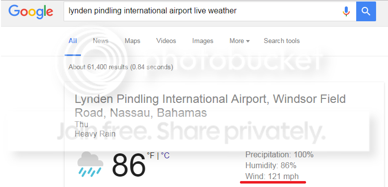
Anybody seen any live updates from Nassau?
Posted on 10/6/16 at 8:31 am to RATeamWannabe
quote:
I remember when people in Denham Springs said that
A little different situation in that than what I'm looking at now.
Posted on 10/6/16 at 8:32 am to NOLA1128
quote:
A little different situation in that than what I'm looking at now.
Yeah just monitor the NHC surge forecast and you should be okay.
Posted on 10/6/16 at 8:34 am to Muice
I really feel for Publix employees. They were at work until 10 last night and were there at 6 am today, all had smiles on their faces. Some of them wanted to evacuate but couldn't because they had to work.
I live in Boynton and work in West Palm and have absolutely no idea what I'm going to go back to. Scheduled to check out of our hotel at noon tomorrow and I'm wondering if I'll even be able to get back.
I live in Boynton and work in West Palm and have absolutely no idea what I'm going to go back to. Scheduled to check out of our hotel at noon tomorrow and I'm wondering if I'll even be able to get back.
Posted on 10/6/16 at 8:36 am to bluemoons
quote:
live updates from Nassau?
They are getting/about to get the NE eyewall right now.
Anyone outside right now is risking their life. It will be very bad there.

This post was edited on 10/6/16 at 8:38 am
Posted on 10/6/16 at 8:36 am to PurpGold 14-0
Joe Bastardi on Twitter saying this thing could go sub 920 MB once it crosses the gulf stream. Those are Katrina numbers.
Posted on 10/6/16 at 8:40 am to NorthEndZone
that is one evil looking image 
Posted on 10/6/16 at 8:44 am to NYNolaguy1
quote:
Joe Bastardi on Twitter saying this thing could go sub 920 MB once it crosses the gulf stream. Those are Katrina numbers.
I know what he means, but damn they treat the Gulf Stream with almost too much respect.
ETA: I mean this thing is sitting over incredibly warm waters the rest of the way no matter what.
This post was edited on 10/6/16 at 8:46 am
Posted on 10/6/16 at 8:44 am to NYNolaguy1
quote:
Joe Bastardi on Twitter saying this thing could go sub 920 MB once it crosses the gulf stream. Those are Katrina numbers.
Was just reading reports on WU blog of lighting in eye wall and speculation that RI could be happening but can't confirm that. Nasty situation with storm approaching gulf stream.

Posted on 10/6/16 at 8:48 am to slackster
quote:
Possible, sure, but nothing in the models suggest it will be anything to worry about after the loop.
Usually, after a hurricane passes through, you have a good number of days of clear dry air to clean up. At best, if this thing does the loop they are predicting, it's going to pass through as a terrible storm, then three days later or so, come in and dump a ton of rain on top of them. Just because it will probably have a bit less wind, doesn't mean it won't be "anything worry about."
Sounds awful to me.

Posted on 10/6/16 at 8:48 am to LSU1NSEC
Is this bastard coming into the GoM?
Posted on 10/6/16 at 8:50 am to NOLA1128
Your position now an evacuation area?
Posted on 10/6/16 at 8:50 am to jimbeam
Too far off to say. It's going to come back and hit Florida again, likely as a category 1 or strong tropical storm on the second pass. What it does from there is still to be determined.

 Page 122 of 181

Popular
Back to top