- My Forums
- Tiger Rant
- LSU Recruiting
- SEC Rant
- Saints Talk
- Pelicans Talk
- More Sports Board
- Fantasy Sports
- Golf Board
- Soccer Board
- O-T Lounge
- Tech Board
- Home/Garden Board
- Outdoor Board
- Health/Fitness Board
- Movie/TV Board
- Book Board
- Music Board
- Political Talk
- Money Talk
- Fark Board
- Gaming Board
- Travel Board
- Food/Drink Board
- Ticket Exchange
- TD Help Board
Customize My Forums- View All Forums
- Show Left Links
- Topic Sort Options
- Trending Topics
- Recent Topics
- Active Topics
Started By
Message

 1
1


Posted on 10/4/22 at 12:05 pm to trussthetruzz
quote:
91L will just slam into Nicaragua if anything forms right?
From this morning's forecast...
quote:
There are no indications this system will threaten the Gulf of Mexico or Florida. Instead, it is expected to track toward Nicaragua and Honduras. The disturbance consists of a large area of disorganized thunderstorms.
Posted on 10/4/22 at 2:15 pm to Oates Mustache
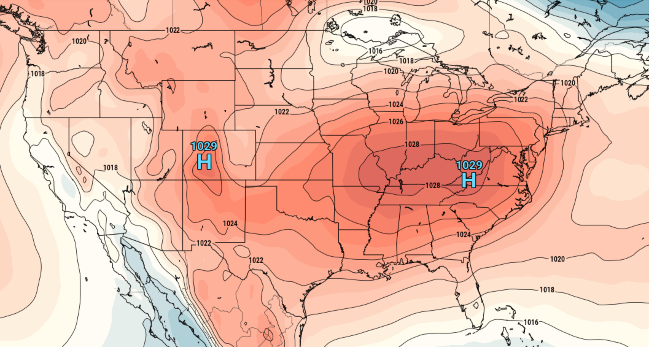
quote:
@BillKarins
A vast sprawling high-pressure system over the eastern half of the nation (blue H) will protect the Gulf Coast states from the next tropical threat in the Caribbean and steer it into Nicaragua or Honduras.

Posted on 10/4/22 at 2:16 pm to Cosmo
quote:
Lowered probability
Always nice to see that puddle of piss rather than the puddle of blood on the 5 day outlook
Not so fast my friend....

But hopefully it heads to Central America...
Posted on 10/4/22 at 2:30 pm to Oates Mustache
quote:
A vast sprawling high-pressure system over the eastern half of the nation (blue H) will protect the Gulf Coast states from the next tropical threat in the Caribbean and steer it into Nicaragua or Honduras.
don't want any tropical systems but we are going to get into a pretty significant drought here if all this dry air and high pressure keeps persisting, it hasn't rained in almost a month now

Posted on 10/4/22 at 8:51 pm to DVinBR
So still header for central America?
Posted on 10/4/22 at 8:56 pm to GREENHEAD22
It depends
Posted on 10/4/22 at 8:57 pm to GREENHEAD22
Everything is pointing that way and Im not seeing anything to open a door north. These storms historically have been flooders for Central America.

Posted on 10/4/22 at 9:05 pm to alphaandomega
quote:

Posted on 10/4/22 at 9:18 pm to Duke
It looks like one wave of high pressure after another for the next couple weeks. Strong fronts too. It’s finally knocked the love bugs out in swla after a damn month of swarming
This post was edited on 10/4/22 at 9:19 pm
Posted on 10/4/22 at 9:25 pm to BregmansWheelbarrow
It looks good to get Louisiana through this last part of the season for LA.
Starts getting really hard to get strong hurricanes into Louisiana by mid October generally.
Starts getting really hard to get strong hurricanes into Louisiana by mid October generally.
Posted on 10/4/22 at 9:35 pm to Duke
Maybe some insurance companies will start writing in our area again
Posted on 10/4/22 at 9:45 pm to alphaandomega
Nothing is happening to put either of these systems in the gulf. This thread can die along with this hurricane season.
Posted on 10/4/22 at 10:45 pm to rds dc
Will blow more Mexicans over the boarder
Posted on 10/6/22 at 10:42 am to Duke
quote:
I wouldnt sleep on the development chances just yet.
I know the models arent biting but it should end up in a favorable pocket of conditions once it gets in front of that upper low to its north.

Posted on 10/6/22 at 2:55 pm to Duke
You don't wish it on anyone but central america typically gets it very bad with these systems. Just goes to show how big the gap is in the world just with small things like information. Wouldn't shock me to see lots of deaths over there.
Posted on 10/11/22 at 8:11 am to rds dc
NHC going 60% for an area of disturbed weather in the BOC. Technically, this probably isn't Julia but it can be traced back to the larger circulation of Julia. It should stay pinned down in the BOC and mark the end of the Gulf season.

This post was edited on 10/11/22 at 8:13 am
Posted on 10/11/22 at 8:18 am to PetroBabich
i mean isn't one of them already in the gulf?
Posted on 10/11/22 at 8:26 am to rds dc
quote:
should stay pinned down in the BOC and mark the end of the Gulf season.
Would the cold front this weekend not open a door north for it if it hangs around that long?

 Page 7 of 7


Popular
Back to top