- My Forums
- Tiger Rant
- LSU Recruiting
- SEC Rant
- Saints Talk
- Pelicans Talk
- More Sports Board
- Fantasy Sports
- Golf Board
- Soccer Board
- O-T Lounge
- Tech Board
- Home/Garden Board
- Outdoor Board
- Health/Fitness Board
- Movie/TV Board
- Book Board
- Music Board
- Political Talk
- Money Talk
- Fark Board
- Gaming Board
- Travel Board
- Food/Drink Board
- Ticket Exchange
- TD Help Board
Customize My Forums- View All Forums
- Show Left Links
- Topic Sort Options
- Trending Topics
- Recent Topics
- Active Topics
Started By
Message
re: Southeast Severe Weather: January 8-9, 2024
Posted on 1/7/24 at 1:21 pm to LegendInMyMind
Posted on 1/7/24 at 1:21 pm to LegendInMyMind
quote:very well described thank you
LegendInMyMind
 1
1

Posted on 1/7/24 at 1:29 pm to cgrand
It is going to take patience with this one. There should be plenty of activity early that won't be too much of a threat. It will look like a bust until it doesn't. It still has a decent chance for a bust, as far as tornadoes are concerned, I think, but not as likely as the similar setup a few weeks ago. Even without a tornado threat materializing the winds could be an issue.
Posted on 1/7/24 at 1:46 pm to blzr
quote:
You also post nothingburger while tornadoes are going off..so
Only because it rustles your jimmies
Posted on 1/7/24 at 1:47 pm to FLTech
quote:
stopped crack years ago. Was getting too expensive
How broke are you? Crack is supposed to be the cheap stuff

Posted on 1/7/24 at 3:37 pm to deltaland
the NHS New Orleans facebook live update did not exactly paint a pretty picture
This post was edited on 1/7/24 at 3:38 pm
Posted on 1/7/24 at 4:35 pm to geauxtigers87
quote:
So when do they start ending school early tomorrow
Ascension apparently posted they are closing early...
quote:
Dear Ascension Public Schools Community,
In light of the upcoming weather forecast for Monday, January 8, 2024, Ascension Public Schools will be implementing a modified schedule due to the anticipated impact of a line of storms in Ascension Parish.
The weather forecast indicates the possibility of high winds in the afternoon, posing a potential threat to the safety of transporting students via school buses. In order to ensure the well-being of our students and staff, we have decided to implement an early dismissal schedule for all schools.
The modified schedule for Monday, January 8, 2024, is as follows:
· Middle Schools (grades 6-8): Dismissal at 11 a.m.
· Primary Schools (grades Pre-K – 5): Dismissal at 12 p.m.
· All Offices: Will close at 1 p.m.
In addition, all after-school activities will be canceled.
We understand the importance of maintaining a safe environment for our students, and this decision has been made with their safety as our top priority. We appreciate your understanding and cooperation in this matter.
Please be advised that high school students are not scheduled to report to school on Monday, January 8, 2024. They will resume their regular schedule on Tuesday, January 9, 2024.
We will continue to monitor the weather conditions closely, and any further updates will be communicated promptly through our official channels and posted on our website, AscensionSchools.org.
Thank you for your cooperation and understanding.
Posted on 1/7/24 at 4:46 pm to geauxtigers87
quote:
the NHS New Orleans facebook live update did not exactly paint a pretty picture
It is a violent atmosphere as far as shear goes. The trend to watch will be temps and dew points. If the mess early clears out and storms get some room to work, the environment only improves into the night.
Initial southeasterly low level flow early will carry those dews into SE Texas. As the surface low moves east, that flow will shift more southerly, increasing moisture across southern LA. The issue is timing and degree of moisture, everything else seems in place with maybe low level lapse rates being an issue, but they will also improve with time.
This post was edited on 1/7/24 at 4:50 pm
Posted on 1/7/24 at 5:03 pm to LegendInMyMind
NWS Mobile has a good Xwitter thread for tomorrow night:
@NWSMobile

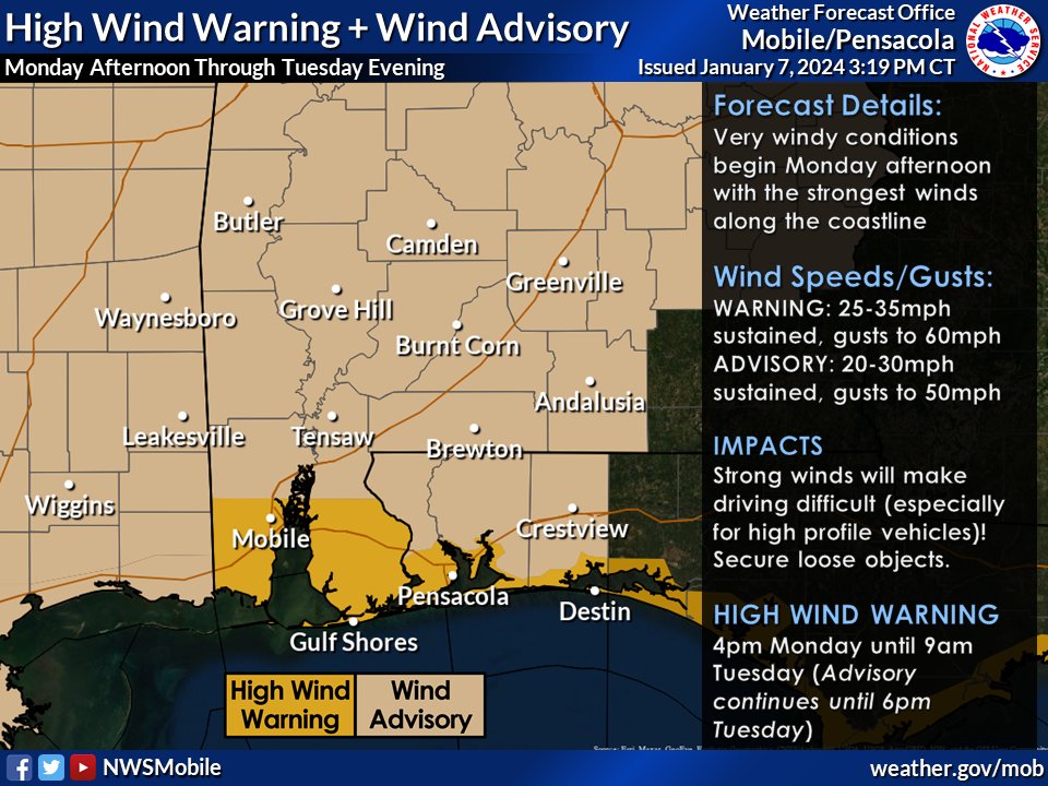
@NWSMobile
quote:
Where to begin? The beginning of this week is shaping up to be VERY IMPACTFUL with the worst of the impacts occurring in the overnight hours. That means you need to start considering how you will prepare SOON.
Let's break down what will happen and potential impacts. (1/6)
quote:
SEVERE STORMS - We are still increasingly concerned about the potential for damaging wind (70+ mph) & tornadoes (some could be strong EF2+) Monday night into Tuesday morning.
Greatest Tornado Threat: 3-9am Tuesday (conditions go downhill quick during that timeframe). (2/6)
quote:
Windy conditions are expected area-wide starting Monday afternoon with VERY WINDY conditions along the coast (gusts to 60mph).
You need to secure/relocate items outside that can blow around. Don’t forget MARDI GRAS DECORATIONS, trash cans, grills, potted plants. (3/6)
quote:
Given the strong winds, there will be a LOT of coastal impacts.
LIFE-THREATENING RIP CURRENTS Monday thru Wednesday night.
HIGH SURF builds to 10+ feet Monday night thru Tuesday night.
COASTAL FLOODING Monday night for the entire coast. Beach erosion likely. (4/6)
quote:
A *rare* STORM WARNING is in effect for all Gulf waters AND the bays, sounds, and waterways beginning Monday afternoon for sustained winds of 30-40 knots and gusts to 55 knots.
Note: this is only the 2nd Storm Warning issued by us since 1994 for the Gulf waters. (5/6)
quote:
Nighttime Storm Safety Reminders:
-Have multiple ways to receive warnings, including one that WAKE YOU UP
-Charge your cellphone before you go to bed
-Ensure the volume on your cellphone is turned up
-Your cellphone should NOT be set to silent or "do not disturb" (6/6)

Posted on 1/7/24 at 5:15 pm to LegendInMyMind
quote:
quote:A *rare* STORM WARNING is in effect for all Gulf waters AND the bays, sounds, and waterways beginning Monday afternoon for sustained winds of 30-40 knots and gusts to 55 knots. Note: this is only the 2nd Storm Warning issued by us since 1994 for the Gulf waters. (5/6)
This is pretty wild.
The Storm Warning calls for the possibility of 10-15 ft. seas.
This post was edited on 1/7/24 at 5:17 pm
Posted on 1/7/24 at 5:22 pm to Roll Tide Ravens
quote:
The Storm Warning calls for the possibility of 10-15 ft. seas.
i could have heard wrong, but the NHS guy in NOLA said 17-20 offshore LA
Posted on 1/7/24 at 5:36 pm to geauxtigers87
Whats the timeline for S Louisiana tomorrow was heading to Texas and may need to push it out a day from the looks of it.
Thx
Thx
Posted on 1/7/24 at 5:43 pm to geauxtigers87
Lafayette parish closing at 1130
Posted on 1/7/24 at 5:45 pm to Tigerfan19
quote:
Whats the timeline for S Louisiana tomorrow was heading to Texas and may need to push it out a day from the looks of it.
Thx
Well, you'll be driving into it. The line forms west of Dallas as early as 6am with rain/storms out ahead of it. There will be rain/thunderstorm chances pretty much all day with the severe threat increasing into the evening and night. Unless you leave very early you will have to drive through the line.
Posted on 1/7/24 at 5:45 pm to LegendInMyMind
Ok, so push the drive out until Tuesday to be safe
Posted on 1/7/24 at 5:59 pm to LegendInMyMind
quote:
You need to secure/relocate items outside that can blow around. Don’t forget FAKE-arse MARDI GRAS DECORATIONS, trash cans, grills, potted plants. (3/6)
FTFY
Posted on 1/7/24 at 6:07 pm to LegendInMyMind
Do you think it will be bad in in Meridian tomorrow night? Have offices in both Meridian and Montgomery that I gotta go visit this week and figure I'll just stay overnight tomorrow night. Which of these two will have the lowest severe threat?
This post was edited on 1/7/24 at 6:24 pm
Posted on 1/7/24 at 6:38 pm to Easye921
quote:
Do you think it will be bad in in Meridian tomorrow night? Have offices in both Meridian and Montgomery that I gotta go visit this week and figure I'll just stay overnight tomorrow night. Which of these two will have the lowest severe threat?
Meridian and Montgomery will definitely get rain and storms, but the worst of the severe weather threat *should* be mostly south of those locations. Both are basically right on the line between the level 1 and level 2 risks.
Strong gradient winds (non-thunderstorm winds) will be an issue across all of Mississippi and Alabama tomorrow/tomorrow night.
This post was edited on 1/7/24 at 6:40 pm
Posted on 1/7/24 at 6:40 pm to Roll Tide Ravens
quote:
The Storm Warning calls for the possibility of 10-15 ft. seas
When the alert hit my phone I didn’t even know what it was.
Thunderstorm warning?
Tornado warning?
Nope, just a “storm warning” in lower case text.
Honestly I thought the NWS was drinking and storm casting.
Posted on 1/7/24 at 6:48 pm to Serial
quote:
Lafayette parish closing at 1130
What happened to the good ole days when a tornado was outside and you got under your desk or in the hallway on the floor.
Posted on 1/7/24 at 7:03 pm to LPLGTiger
Washington Parish dismissal at 11:20.

 Page 3 of 36

Popular
Back to top