- My Forums
- Tiger Rant
- LSU Recruiting
- SEC Rant
- Saints Talk
- Pelicans Talk
- More Sports Board
- Fantasy Sports
- Golf Board
- Soccer Board
- O-T Lounge
- Tech Board
- Home/Garden Board
- Outdoor Board
- Health/Fitness Board
- Movie/TV Board
- Book Board
- Music Board
- Political Talk
- Money Talk
- Fark Board
- Gaming Board
- Travel Board
- Food/Drink Board
- Ticket Exchange
- TD Help Board
Customize My Forums- View All Forums
- Show Left Links
- Topic Sort Options
- Trending Topics
- Recent Topics
- Active Topics
Started By
Message
re: Significant Friday evening east Texas severe weather threat
Posted on 11/3/22 at 2:36 pm to East Coast Band
Posted on 11/3/22 at 2:36 pm to East Coast Band
I'll be leaving West of Fort Worth at noon driving to Toledo Bend. Knowing my luck I'll stay right under the storm cloud the entire way there.
 1
1

Posted on 11/3/22 at 2:42 pm to WhiskeyThrottle
quote:
I'll be leaving West of Fort Worth at noon driving to Toledo Bend. Knowing my luck I'll stay right under the storm cloud the entire way there.
If you could make that trip a couple hours earlier it would be much better for you.
Posted on 11/3/22 at 2:55 pm to LegendInMyMind
My buddy that is rolling with me has to work till noon. I'm going to see if he can get out a little earlier but he's saying it's a no go with work so far. Just hoping the storm stalls for an hour or two right now. Not holding my breath.
Fortunately I got new tires today so I won't be hydroplaning as easy as the previous set.
Fortunately I got new tires today so I won't be hydroplaning as easy as the previous set.
Posted on 11/3/22 at 2:58 pm to WhiskeyThrottle
This is around 3pm.

Posted on 11/3/22 at 2:59 pm to WhiskeyThrottle
Steve Caparotta, Ph.D.
@SteveWAFB
·
3h
Replying to
@SteveWAFB
The inital line of storms early Saturday morning may come with at least a low-end severe weather threat. SPC has a Level 1/5 (marginal) risk from Baton Rouge westward. Damaging winds are the primary concern.

Steve Caparotta, Ph.D.
@SteveWAFB
·
3h
While the news is good for the game itself, morning tailgates & tailgate setup could be a mess. Not only is rain likely, it could be heavy. WPC shows totals averaging 0.75"-2" across our area, locally higher possible. Level 1/4 (marginal) risk of flooding.

@SteveWAFB
·
3h
Replying to
@SteveWAFB
The inital line of storms early Saturday morning may come with at least a low-end severe weather threat. SPC has a Level 1/5 (marginal) risk from Baton Rouge westward. Damaging winds are the primary concern.
Steve Caparotta, Ph.D.
@SteveWAFB
·
3h
While the news is good for the game itself, morning tailgates & tailgate setup could be a mess. Not only is rain likely, it could be heavy. WPC shows totals averaging 0.75"-2" across our area, locally higher possible. Level 1/4 (marginal) risk of flooding.
Posted on 11/3/22 at 4:05 pm to rds dc
Lots of talk now about prefrontal discrete cells popping up tomorrow evening. NE Texas looks like the hot zone. SPC using the "strong tornado or two" language.
Posted on 11/3/22 at 4:28 pm to Lsuhoohoo
The most obvious failure mode, in regards to pre-frontal discrete development, for tomorrow is the cap not holding and allowing for a messy storm mode that lines out quicker/earlier.
That's still a possibility, though I don't think it is a likely one.
It would still result in embedded or semi discrete supercells that would have really good parameters to work with. It will eventually go linear, anyway, but with the amount of shear there will still be a tornado threat in the line itself.
Posted on 11/4/22 at 7:07 am to The Boat

quote:
Severe thunderstorms are likely today and tonight over parts of northern and eastern Texas, eastern Oklahoma, southwest Arkansas and western Louisiana. Several tornadoes are possible over far southeast Oklahoma and eastern Texas. A line associated with damaging winds will spread into Arkansas and Louisiana overnight. A strong tornado or two may occur from late afternoon into early evening.
Posted on 11/4/22 at 8:58 am to East Coast Band
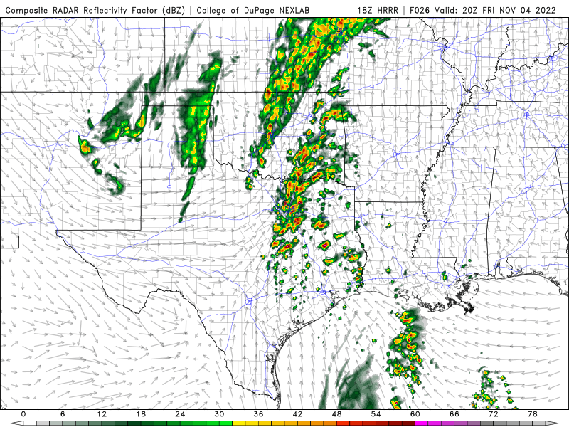
The broken line nature of this system heading into Louisiana is of some concern.
This is in the Alexandria area around 10pm:
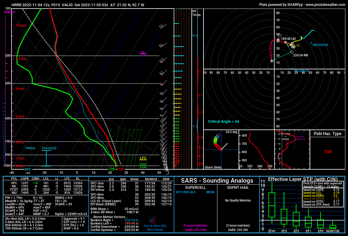
A sounding for the same time period from the NAM is similar, with higher SRH.
This is what the HRRR shows when it gets into LA:
It is similar for the NAM.
It'll be messy, but it will have good ingredients to work with. It still looks like pre-frontal activity will still be going on well into LA with at least embedded and/or semi-discrete supercells with the line playing catchup behind them. The line will eventually fill in, but it will take time.
Just because you're in the yellow, or Slight Risk, area doesn't mean a strong tornado won't be possible. It will be an overnight threat, so have a way to get warnings that will wake you up.
This is in the Alexandria area around 10pm:
A sounding for the same time period from the NAM is similar, with higher SRH.
This is what the HRRR shows when it gets into LA:
It is similar for the NAM.
It'll be messy, but it will have good ingredients to work with. It still looks like pre-frontal activity will still be going on well into LA with at least embedded and/or semi-discrete supercells with the line playing catchup behind them. The line will eventually fill in, but it will take time.
Just because you're in the yellow, or Slight Risk, area doesn't mean a strong tornado won't be possible. It will be an overnight threat, so have a way to get warnings that will wake you up.
Posted on 11/4/22 at 9:18 am to LegendInMyMind
quote:
The broken line nature of this system heading into Louisiana is of some concern
On the bright side, it looks like most all the rain should be done in BR by kickoff.
Posted on 11/4/22 at 9:23 am to LegendInMyMind
The rainfall will be good news concerning the low water level in the lower Mississippi River. Now we need a lot of rainfall in the Missouri River and Ohio River to help out the Upper Mississippi River and get these stranded barges loaded with soybeans, wheat, corn, etc moving to market.
Posted on 11/4/22 at 9:28 am to rds dc
quote:
On the bright side, it looks like most all the rain should be done in BR by kickoff.
I'd definitely throw something heavy on the smoker, maybe a whole hog.
Posted on 11/4/22 at 11:26 am to rds dc
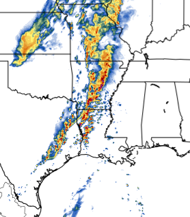
Latest observed sounding out of Dallas.

Posted on 11/4/22 at 11:51 am to LegendInMyMind
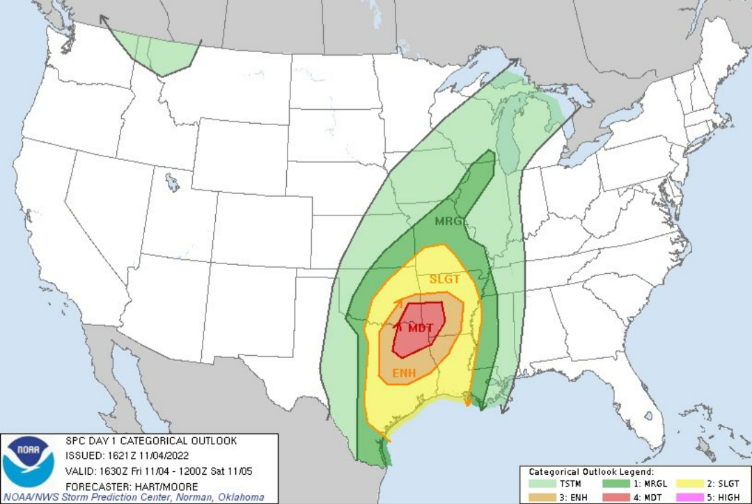
Got the MOD upgrade.

Posted on 11/4/22 at 11:59 am to LegendInMyMind
The current weather in the area looks pretty linear right now. Isnt this what we hope for?
The discrete cells are the bigger issue.
The discrete cells are the bigger issue.

Posted on 11/4/22 at 12:00 pm to LegendInMyMind
quote:
Got the MOD upgrade.
Don’t see a moderate risk too often in early November.

Posted on 11/4/22 at 12:04 pm to Roll Tide Ravens
You could feel it coming with a day 3 enhanced. The parameters are strong
Posted on 11/4/22 at 12:04 pm to 50_Tiger
The HRRR has shown that little line firing with discrete/semi-discrete cells firing to the South and moving NE and continuing to fire.
Anything to take some of the high end potential off is good, but I wouldn't be fooled by the early convection. So far, it isn't doing anything unexpected.
Anything to take some of the high end potential off is good, but I wouldn't be fooled by the early convection. So far, it isn't doing anything unexpected.
This post was edited on 11/4/22 at 12:05 pm
Posted on 11/4/22 at 12:19 pm to The Boat
Temps dropping in Western OK as the front passed through. Around a 25° swing.
This post was edited on 11/4/22 at 12:20 pm


 Page 3 of 14

Popular
Back to top