- My Forums
- Tiger Rant
- LSU Recruiting
- SEC Rant
- Saints Talk
- Pelicans Talk
- More Sports Board
- Fantasy Sports
- Golf Board
- Soccer Board
- O-T Lounge
- Tech Board
- Home/Garden Board
- Outdoor Board
- Health/Fitness Board
- Movie/TV Board
- Book Board
- Music Board
- Political Talk
- Money Talk
- Fark Board
- Gaming Board
- Travel Board
- Food/Drink Board
- Ticket Exchange
- TD Help Board
Customize My Forums- View All Forums
- Show Left Links
- Topic Sort Options
- Trending Topics
- Recent Topics
- Active Topics
Started By
Message
re: Severe weather threat for Today/Tomorrow across the SE All severe modes possible
Posted on 2/16/23 at 10:23 am to Thracken13
Posted on 2/16/23 at 10:23 am to Thracken13
quote:
well that isn't good - im on some of that yellow
It is just another product to use. It attempts to get more specific than the SPC. It has gotten better over the years, but isn't perfect.
 2
2

Posted on 2/16/23 at 10:24 am to LegendInMyMind
quote:
Nadocast has zeroed in on SE MS and Central AL for the highest tornado risk.
That seems to be the case with almost every severe system lately
Laurel, Ms and Eutaw, Al looks to be ground zero once again
Posted on 2/16/23 at 10:25 am to LegendInMyMind
in fairness - I typically do not go along with the color lines - if the cutoff between colors is within 100 miles of Birmingham, then I consider it a real possibility and trend to the worse side.
my nerves now is because my wife and I moved into our 1st house, and have been here less than a month. different creature when it is your house and not an apartment lol
my nerves now is because my wife and I moved into our 1st house, and have been here less than a month. different creature when it is your house and not an apartment lol
Posted on 2/16/23 at 10:29 am to Thracken13
quote:
in fairness - I typically do not go along with the color lines - if the cutoff between colors is within 100 miles of Birmingham, then I consider it a real possibility and trend to the worse side.
That's the outlook everyone should have. Colors on a graphic aren't definite. Too many people take those to heart.
Posted on 2/16/23 at 10:29 am to LegendInMyMind
I hate yellow. That color doesn't look good on me, but I'm smack dab in the middle of that yellow footprint
Posted on 2/16/23 at 10:30 am to East Coast Band
I am to your left Lol
Posted on 2/16/23 at 10:32 am to deltaland
quote:
Eutaw, Al
Never fails. About to lose some more trees at the very least I'm sure
Posted on 2/16/23 at 10:32 am to LegendInMyMind
I can't remember when exactly it was maybe last year or the year before. Whenever Jason Simpson was still in Huntsville but he said that more tornadoes at that time had happened slight (yellow) than the enhanced (orange). That's why he would stress don't pay attention to what color your are in.

Posted on 2/16/23 at 10:36 am to deltaland
quote:I think thats the area I saw ULM atmos deploy their mobile LiDAR.
Laurel, Ms and Eutaw, Al looks to be ground zero once again
Posted on 2/16/23 at 10:36 am to trussthetruzz
quote:
The new radar in St Francisville has been activated today!
quote:
Not seeing it on radarscope. Will it be added there?
It may not be publicly-accesible. It looks to be a proprietary WAFB radar. They and NWS offices would have access, but it will probably never show up on the radar apps for public use. It is probably on the WAFB weather app with limited features, though. That's how most stations do it.
ETA: Yep, that's the deal. No public access.
From a WAFB article:
quote:
BATON ROUGE, La. (WAFB) - WAFB today announced the installation of its exclusive new high-resolution weather radar, helping to fill a dangerous gap in radar coverage within the communities we serve.
quote:
As part of a public-private partnership agreement, emergency preparedness officials in West Feliciana Parish will also have access to the radar.
The new radar will also be accessible on WAFB’s website and news APP.
This post was edited on 2/16/23 at 10:45 am

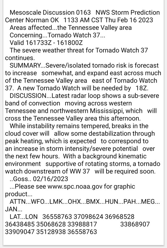
Posted on 2/16/23 at 11:34 am to Thracken13
quote:
in fairness - I typically do not go along with the color lines - if the cutoff between colors is within 100 miles of Birmingham, then I consider it a real possibility and trend to the worse side.
That’s the outlook to have. The storms aren’t aware of any of these graphics. They don’t cross from the enhanced risk area into the slight risk area and say to themselves “I’m in the slight risk area now, I better calm down some.” If a person is in a severe weather risk area, they should pay attention regardless of what level the risk is.
This post was edited on 2/16/23 at 11:35 am

Posted on 2/16/23 at 11:40 am to Roll Tide Ravens

Posted on 2/16/23 at 11:42 am to LegendInMyMind
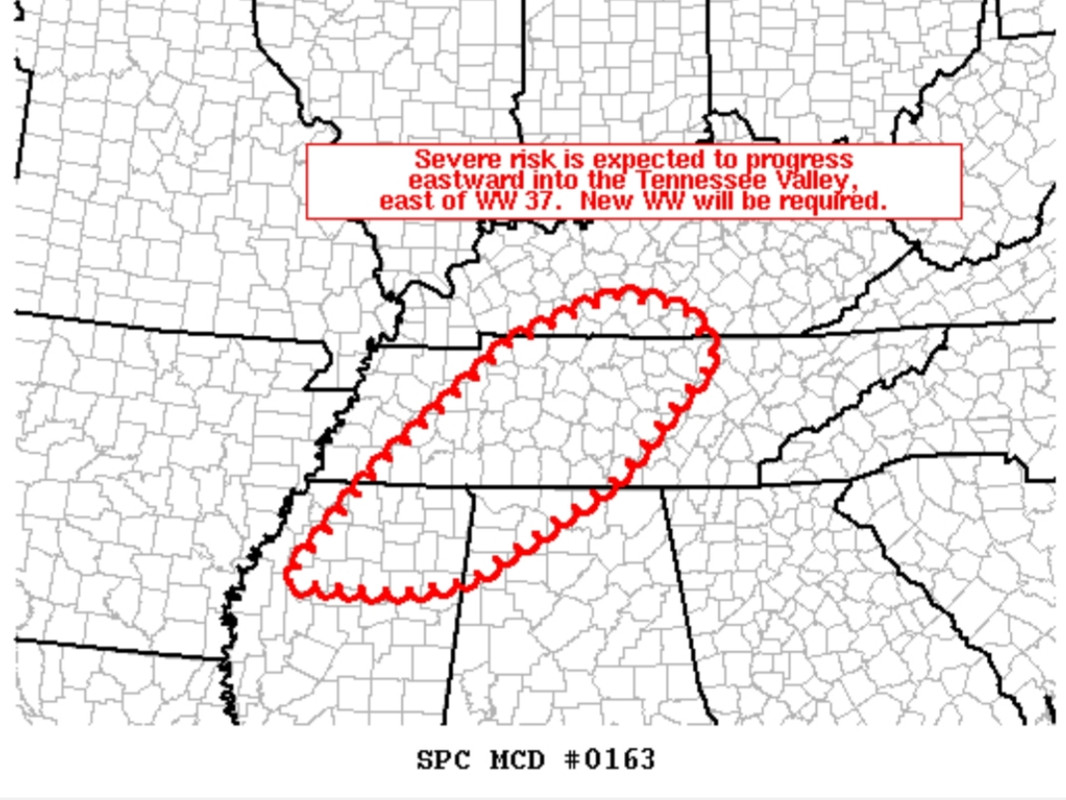
I may end up being horribly wrong but sort of seems to me Tennsippibama is gonna be relatively ok on the tornado front. We will prolly get a strong storm out of the line maybe with some winds but that'll be about it
Those to our south better hold onto their butts
Those to our south better hold onto their butts
Posted on 2/16/23 at 11:43 am to LegendInMyMind
Wonder if it'd be available through GR. I seem to remember the ULM radar being on there but that couldve just been because we were on campus.
Posted on 2/16/23 at 11:44 am to Wishnitwas1998
Sun just broke through the clouds temps just jumped from 70 to 76 in 10 minutes.
Won’t hurt us the line is almost here and looks like nothing. To our east it may get nasty once it has time to build up
Won’t hurt us the line is almost here and looks like nothing. To our east it may get nasty once it has time to build up
Posted on 2/16/23 at 11:44 am to Thracken13
quote:
Thracken13
Here we go again neighbor. I'm just south of you if I remember correctly.
We're going to have to start having tornado parties if this shite keeps up.
Posted on 2/16/23 at 11:47 am to Wishnitwas1998
quote:
I may end up being horribly wrong but sort of seems to me Tennsippibama is gonna be relatively ok on the tornado front.
The storm that just rolled through Memphis was mainly just really heavy rain
Posted on 2/16/23 at 11:50 am to deltaland
quote:
Sun just broke through the clouds temps just jumped from 70 to 76 in 10 minutes.
Won’t hurt us the line is almost here and looks like nothing. To our east it may get nasty once it has time to build up
Yeah, I've been thinking you'd luck out,timing wise, with this one.
Posted on 2/16/23 at 11:50 am to BoogaBear
LOL yup you are.

 Page 6 of 11

Popular
Back to top