- My Forums
- Tiger Rant
- LSU Recruiting
- SEC Rant
- Saints Talk
- Pelicans Talk
- More Sports Board
- Fantasy Sports
- Golf Board
- Soccer Board
- O-T Lounge
- Tech Board
- Home/Garden Board
- Outdoor Board
- Health/Fitness Board
- Movie/TV Board
- Book Board
- Music Board
- Political Talk
- Money Talk
- Fark Board
- Gaming Board
- Travel Board
- Food/Drink Board
- Ticket Exchange
- TD Help Board
Customize My Forums- View All Forums
- Show Left Links
- Topic Sort Options
- Trending Topics
- Recent Topics
- Active Topics
Started By
Message
re: Severe weather threat for Today/Tomorrow across the SE All severe modes possible
Posted on 2/16/23 at 11:53 am to Pedro
Posted on 2/16/23 at 11:53 am to Pedro
quote:
Wonder if it'd be available through GR. I seem to remember the ULM radar being on there but that couldve just been because we were on campus.
The ULM radar is available on Radar Omega and maybe some other apps, but not RadarScope. I don't know if GR would have it without the right kind of key code. It is the same with station radars in my area. The ABC affiliate has three exclusive radars here in the Shoals, Decatur area, and Sand Mountain. None are available to the public, except through their app, and only offers Reflectivity.
Radar Omega has quite a few radars not available elsewhere. They're actually working to fill radar gaps.
This post was edited on 2/16/23 at 11:55 am
 1
1

Posted on 2/16/23 at 11:55 am to LegendInMyMind
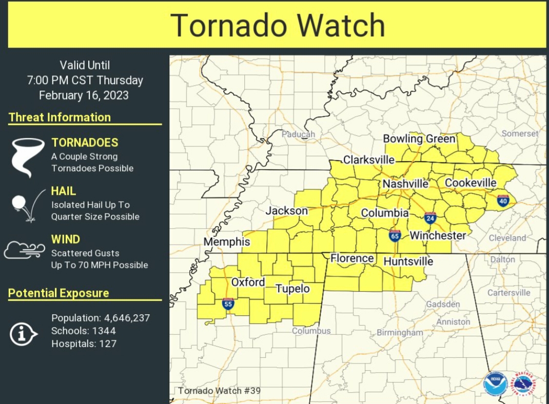
I post I think we are gonna be ok then they immediately circle me and release a graphic 
Posted on 2/16/23 at 12:00 pm to Wishnitwas1998
And that tornado watch just went out.
This post was edited on 2/16/23 at 12:02 pm
Posted on 2/16/23 at 12:04 pm to LegendInMyMind
Line is moving slow. It’s developing fairly rapidly looks like it wants to break up into more discrete cells instead of o QLCS
Posted on 2/16/23 at 12:07 pm to deltaland
Yea it does look like it's trying to break up
Pretty rare for one to form like that then break up into strong storms. They will break up and weaken but don't think I've seen them stay strong in our area very often. We will see
Pretty rare for one to form like that then break up into strong storms. They will break up and weaken but don't think I've seen them stay strong in our area very often. We will see
Posted on 2/16/23 at 12:22 pm to Wishnitwas1998
Was just heavy rain no storms. Must still be capped preventing convection

Posted on 2/16/23 at 12:42 pm to LegendInMyMind
Yea I just downloaded GR on my work computer and it looks like ULM is missing sadly. I forgot how nice this shite was
Posted on 2/16/23 at 12:44 pm to Pedro
I think you'd like Radar Omega. It is similarly priced to RadarScope.
Posted on 2/16/23 at 12:47 pm to LegendInMyMind
quote:I'll have to check that out. GR didnt give me the usual Trial warning so I'm holding out hope I have access since im accessing it from a school server. Im sure itll restrict me eventually though.
I think you'd like Radar Omega. It is similarly priced to RadarScope.

Posted on 2/16/23 at 1:01 pm to Roll Tide Ravens
Tornado Warning east of Clarksburg, TN.
Posted on 2/16/23 at 1:02 pm to Pedro
Tornado warning north of me up in west central Tennessee. Seemingly came out of no where
Posted on 2/16/23 at 1:09 pm to Wishnitwas1998
decent rotation on that cell. Doesnt seem like anythings on teh ground currently though

Posted on 2/16/23 at 1:28 pm to Pedro

Posted on 2/16/23 at 1:28 pm to Pedro
Nice volocity couplet on the warned cell north of mount pleasant, MS
Posted on 2/16/23 at 1:31 pm to Bobby OG Johnson
Warning NW of Laurel
Posted on 2/16/23 at 1:31 pm to Wishnitwas1998
We can always count on a warning near Laurel
Posted on 2/16/23 at 1:32 pm to deltaland
quote:
We can always count on a warning near Laurel
Always.
Posted on 2/16/23 at 1:32 pm to deltaland
WAs watching that cell earlier and it seemed like it was getting it's act together
Posted on 2/16/23 at 1:33 pm to Wishnitwas1998
quote:
Nice volocity couplet on the warned cell north of mount pleasant, MS
That one has potential.

 Page 7 of 11

Popular
Back to top