- My Forums
- Tiger Rant
- LSU Recruiting
- SEC Rant
- Saints Talk
- Pelicans Talk
- More Sports Board
- Fantasy Sports
- Golf Board
- Soccer Board
- O-T Lounge
- Tech Board
- Home/Garden Board
- Outdoor Board
- Health/Fitness Board
- Movie/TV Board
- Book Board
- Music Board
- Political Talk
- Money Talk
- Fark Board
- Gaming Board
- Travel Board
- Food/Drink Board
- Ticket Exchange
- TD Help Board
Customize My Forums- View All Forums
- Show Left Links
- Topic Sort Options
- Trending Topics
- Recent Topics
- Active Topics
Started By
Message
re: Severe weather threat for Today/Tomorrow across the SE All severe modes possible
Posted on 2/16/23 at 1:40 pm to LegendInMyMind
Posted on 2/16/23 at 1:40 pm to LegendInMyMind
Probably on the ground in Ripley.
 1
1


Posted on 2/16/23 at 1:46 pm to LegendInMyMind
yep confirmed

Posted on 2/16/23 at 1:47 pm to Pedro

Posted on 2/16/23 at 1:51 pm to Bobby OG Johnson

Posted on 2/16/23 at 1:52 pm to Wishnitwas1998
My wife does home health nursing and was in the direct path of that Warner storm south of selmer, TN. She was in Stantonville and had no where to take shelter so I told her to haul arse towards Selmer. Hopefully she will be able to stay north of it I think so
Posted on 2/16/23 at 1:52 pm to Bobby OG Johnson
If that one holds together I'll have to deal with it in a bit
Posted on 2/16/23 at 1:54 pm to Wishnitwas1998
Looks like the Laurel cell may have a bit of a debris signature
Posted on 2/16/23 at 1:55 pm to Wishnitwas1998
quote:
My wife does home health nursing and was in the direct path of that Warner storm south of selmer, TN. She was in Stantonville and had no where to take shelter so I told her to haul arse towards Selmer. Hopefully she will be able to stay north of it I think so
The good news is that most of the line isn't severe right now, so she should be fine just getting out of the line of that storm.
Posted on 2/16/23 at 1:56 pm to LegendInMyMind

Posted on 2/16/23 at 1:56 pm to Pedro
quote:
Looks like the Laurel cell may have a bit of a debris signature
Looks like it may have briefly, but has broadened out again.
Posted on 2/16/23 at 1:59 pm to Bobby OG Johnson
They still have the confirmed tag on that Ripley warning. Doesn't look as good on radar. Radar confirmed, but there should be some chasers on that storm, several were in the Columbus area earlier.
Posted on 2/16/23 at 2:00 pm to LegendInMyMind
Yea she made it to selmer and is behind the line now.
Posted on 2/16/23 at 2:00 pm to LegendInMyMind
Little energy popping
Posted on 2/16/23 at 2:08 pm to Bobby OG Johnson
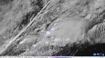
So much going on there, so cool to look at could watch it for a hour
Posted on 2/16/23 at 2:18 pm to Wishnitwas1998
Corinth cell is trying to wrap back up.
Posted on 2/16/23 at 2:20 pm to LegendInMyMind
Yea if it holds its current track it's gonna be a close call but should go a mile or two to my south

Posted on 2/16/23 at 2:22 pm to LegendInMyMind
Legend do me a favor and see whats going on in Walker. I’m at the ER
With wife. Worried about my puppy.
With wife. Worried about my puppy.
Posted on 2/16/23 at 2:25 pm to LegendInMyMind
Just heard a new one
"A wet microburst"
The jokes write themselves
"A wet microburst"
The jokes write themselves
This post was edited on 2/16/23 at 2:25 pm
Posted on 2/16/23 at 2:25 pm to Wishnitwas1998

Posted on 2/16/23 at 2:26 pm to dukke v
quote:
Legend do me a favor and see whats going on in Walker.
Nothing right now. The line is still a ways away, and there's nothing severe to the west of there.
This post was edited on 2/16/23 at 2:28 pm

 Page 8 of 11

Popular
Back to top