- My Forums
- Tiger Rant
- LSU Recruiting
- SEC Rant
- Saints Talk
- Pelicans Talk
- More Sports Board
- Fantasy Sports
- Golf Board
- Soccer Board
- O-T Lounge
- Tech Board
- Home/Garden Board
- Outdoor Board
- Health/Fitness Board
- Movie/TV Board
- Book Board
- Music Board
- Political Talk
- Money Talk
- Fark Board
- Gaming Board
- Travel Board
- Food/Drink Board
- Ticket Exchange
- TD Help Board
Customize My Forums- View All Forums
- Show Left Links
- Topic Sort Options
- Trending Topics
- Recent Topics
- Active Topics
Started By
Message
re: Severe weather threat for Today/Tomorrow across the SE All severe modes possible
Posted on 2/16/23 at 7:07 am to Bobby OG Johnson
Posted on 2/16/23 at 7:07 am to Bobby OG Johnson
No way Alabama or Mississippi makes it through the day without at least one tornado warning.
 1
1

Posted on 2/16/23 at 7:12 am to East Coast Band
Fun drive into work. fricking monsoon, hail, wind, crazy arse lightning.
Love doing 30mph on the interstate.
Love doing 30mph on the interstate.
Posted on 2/16/23 at 7:46 am to LegendInMyMind
Large hatched area for tornados

Posted on 2/16/23 at 7:51 am to NorthEndZone
All in the hatched area.
Looks like another day with Spann the man.
Looks like another day with Spann the man.
Posted on 2/16/23 at 8:28 am to BoogaBear
Driving back to Bham from Atlanta this afternoon should be fun.
Posted on 2/16/23 at 8:30 am to ATLwreck
quote:
Driving back to Bham from Atlanta this afternoon should be fun.
I hope your username doesn’t come to fruition

Posted on 2/16/23 at 8:32 am to lsuman25
quote:
The new radar in St Francisville has been activated today!
Not seeing it on radarscope. Will it be added there?
Posted on 2/16/23 at 8:34 am to schwartzy
quote:
I hope your username doesn’t come to fruition

Posted on 2/16/23 at 8:37 am to ATLwreck
We were supposed to have storms overnight and Nada

Posted on 2/16/23 at 8:58 am to Jim Rockford
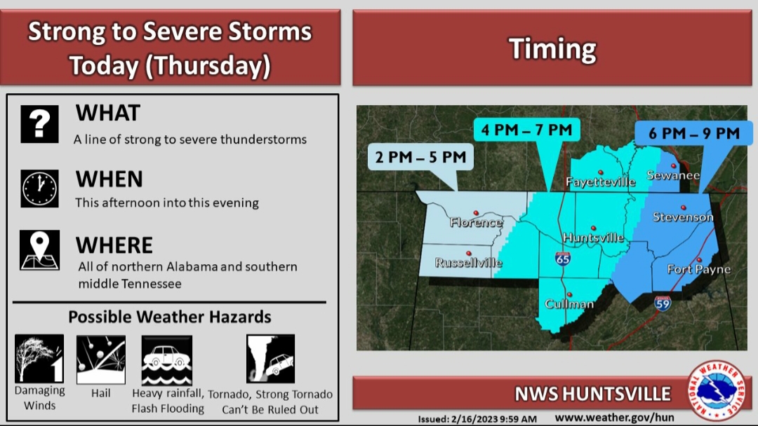
In the graphic they put out overnight NWS Bham noted the potential for strong tornadoes in the enhanced risk area.

Posted on 2/16/23 at 9:21 am to Roll Tide Ravens
im in, got ABC3340 ready to stream.
i love severe weather - but i sincerely hope noone gets hurt .
i love severe weather - but i sincerely hope noone gets hurt .

Posted on 2/16/23 at 9:22 am to LegendInMyMind
Steve Caparotta, Ph.D.
@SteveWAFB
·
8m
Keeping a close eye on a cell tracking right toward our new radar in W. Feliciana Parish. That radar with a good look at the low-levels detecting some rotation.


This post was edited on 2/16/23 at 9:24 am
Posted on 2/16/23 at 9:37 am to Thracken13
Getting some peeks of sun in the Birmingham area. Not what we want to see.
This post was edited on 2/16/23 at 9:39 am
Posted on 2/16/23 at 9:41 am to Roll Tide Ravens
that was my thought as I was coming in from getting the trash can from the street.
Posted on 2/16/23 at 10:00 am to Thracken13
For those smarter than me: from the NWS in Birmingham a short while ago:
quote:
Area Forecast Discussion National Weather Service Birmingham AL 858 AM CST Thu Feb 16 2023 ...New MESOSCALE UPDATE... .MESOSCALE UPDATE FOR SEVERE WEATHER... Issued at 856 AM CST THU FEB 16 2023 Previous forecast remains on-track. Overnight modeling along with 06z and 12z local and regional soundings indicate stronger capping has materialized and is helping to suppress shower development across the area early this morning. The forecast area remains positioned between a broad mid-level ridge over the Bahamas and Cubs while a closed low was located over North-Central Kansas embedded within a positive tilt trough over the plains. Surface high pressure was positioned further east across the Central Atlantic while surface low pressure was positioned across the Ozark Mountains in Arkansas. A stationary front extends northeast of the low across the Ohio River Valley while a cold front extends from the surface low south into Coastal Texas. Local enhanced RAP 13 km mesoanalysis depicts a broad warm sector encompassing all of Mississippi into at least the western half of Central Alabama, characterized by temperatures already in the upper 60s to around 70 degrees. Dew points, likewise, are in the low to mid 60s across Mississippi into much of Alabama. With the more robust capping and some cloud breaks, while our forecast high temperatures have been toward the upper end of guidance, it remains potentially attainable in this scenario. More that sufficient instability will exist with uncharacteristically high numbers of buoyancy that exceeds the more typical values experienced for this time of year in our part of the country. In the shear-instability parameter space, we more typically focus on the lower CAPE-higher shear portion of the spectrum, however, setups like this resemble the more opposite end of the spectrum for our area with higher CAPE values that do not require as strong of magnitude of shear than we typically expect. Wind shear is more than sufficient for severe thunderstorms and tornadoes. The capping off the surface, as depicted on the observed soundings, are associated with a slug of drier air that composes the Elevated Mixed Layer. Some of this drier air will work downward toward the surface and can result in at least a temporary reduction in low level moisture. As we progress through later this afternoon and into the evening hours, boundary layer vertical mixing will decrease and this will allow for low-level moisture values to increase. Due to this potential, we may see slightly higher-based convection through the afternoon hours with potentially increased visibility of supercell structures with the more classic supercell storm mode preferred. As we move into the evening and overnight, the low-level moisture values will again increase and result in lower cloud bases, lower lifted condensation level heights, and will continue to support nocturnal severe weather and tornado potential. Additionally, as vertical mixing decreases into the evening, the low-level jet is expected to intensify as well, further providing sufficient wind fields for severe storms and some tornadoes. The overall event storm mode will support supercell structures with an overall general tendency to eventually attempt to congeal into a line of deep convection. It is expected for supercells to develop and move across portions of the western and into the central counties this afternoon and evening. For the later part of the evening and overnight, we could retain some supercells across the eastern counties, though some linear formation would eventually be expected. Given continued cloud breaks south, persistent low-level warm advection and a gradually eroding capping inversion that looks to give way across the area with time as shortwave impulses with some height falls later today will support all modes of severe weather. Tornadoes will be an areawide risk with best potential at least initially across portions of the west and southwest counties through early afternoon. Damaging winds will be possible, especially with any linear convective configuration that materializes later today. Large hail will be possible with the stronger storms as more intense updrafts are expected given the stronger buoyancy. Additionally, localized flooding will be possible where training of heavy convection occurs, especially over terrain and urbanized areas. Through noon, expect a few low-topped light showers will still occur from time to time through the morning hours that develop beneath the cap located around 805 mb per latest sounding. This activity will move quickly northeast over 50 mph as the low-level jet from the southwest continues to increase in the lower and mid levels. We are monitoring convection developing over Southern Mississippi that will be moving northeast toward our southwest counties towards early afternoon. The next mesoscale update will be sent by noon. 05
Posted on 2/16/23 at 10:08 am to Roll Tide Ravens
Across the warm sector of MS/AL we still have a cap in place this morning. That's not really a good thing. The cap should erode (looking at soundings on the HRRR) within the next couple hours. BMX's observed sounding this morning also showed the cap in place.
The problem is, temps are already touching 70° in MS and the upper 60s across most of AL. You don't need anything except your eyes to see the moisture in place. There's a light fog/haze in the air at my place right now in North AL. We're still pretty socked in by clouds right now, but any sun that peeks through will only help destabilize us more.
The latest HRRR runs show a mess of storms forming ahead of the front in central AL. My hope is that those aren't all that bad and they can cut off the storms over North AL. That would be the best thing for most AL folks.
Now, we just wait and see. Personally, I hope to see a lot of bitching about this being a bust tonight. That wouldn't hurt my feelings at all.
This post was edited on 2/16/23 at 10:14 am
Posted on 2/16/23 at 10:11 am to LegendInMyMind
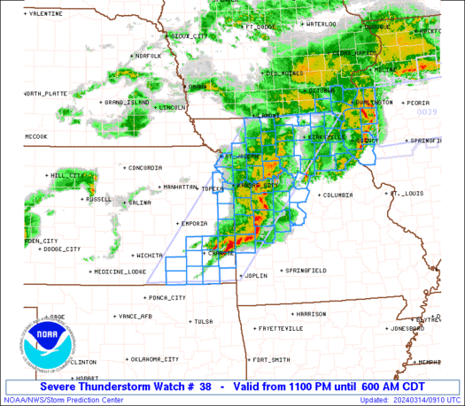
New tornado watch...
Posted on 2/16/23 at 10:17 am to NorthEndZone
Nadocast has zeroed in on SE MS and Central AL for the highest tornado risk.
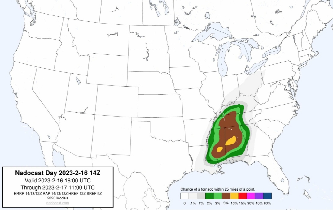
The colors are pretty much equivalent to the SPC products.
The colors are pretty much equivalent to the SPC products.
Posted on 2/16/23 at 10:20 am to LegendInMyMind
well that isn't good - im on some of that yellow

 Page 5 of 11

Popular
Back to top