- My Forums
- Tiger Rant
- LSU Recruiting
- SEC Rant
- Saints Talk
- Pelicans Talk
- More Sports Board
- Coaching Changes
- Fantasy Sports
- Golf Board
- Soccer Board
- O-T Lounge
- Tech Board
- Home/Garden Board
- Outdoor Board
- Health/Fitness Board
- Movie/TV Board
- Book Board
- Music Board
- Political Talk
- Money Talk
- Fark Board
- Gaming Board
- Travel Board
- Food/Drink Board
- Ticket Exchange
- TD Help Board
Customize My Forums- View All Forums
- Show Left Links
- Topic Sort Options
- Trending Topics
- Recent Topics
- Active Topics
Started By
Message

 0
0

Posted on 4/12/22 at 1:49 pm to deltaland
Oh boy! We got a slew of 18z soundings to take a look at.
Davenport, IA:

Hodo nearly textbook. Thermo sucks. Going to really need to warm up and get some higher dew points advected in quickly if the chasers are going to have a good day.
Norman, OK:

Thermo better, but still quite dry. In addition there's a pretty stout cap there. It has risen some and eroded since this morning, but that's expected. Fight between building low level instability and forcing vs no upper level help for ascent.
Dallas:

Once again, we have a cap. It is not as pronounced as Norman and the moisture is better overall. Just above the cap looks primed for hail, and the low level shear is better than I was expecting.
Gonna have to watch Texas this afternoon for sure.
Now the most surprising profile, to me, Lake Charles:

That's more shear in the low levels than was being advertised by models yesterday. Plenty of instability already with a very modest inversion about 800 mb. Don't trust storms that can get going in this environment.
Corpus has 6000 J/kg CAPE but I have some questions about the moisture and temperature from the surface vs just above. The mixed layer is probably more realistic at 2800 J/kg (which is plenty).
Davenport, IA:
Hodo nearly textbook. Thermo sucks. Going to really need to warm up and get some higher dew points advected in quickly if the chasers are going to have a good day.
Norman, OK:
Thermo better, but still quite dry. In addition there's a pretty stout cap there. It has risen some and eroded since this morning, but that's expected. Fight between building low level instability and forcing vs no upper level help for ascent.
Dallas:
Once again, we have a cap. It is not as pronounced as Norman and the moisture is better overall. Just above the cap looks primed for hail, and the low level shear is better than I was expecting.
Gonna have to watch Texas this afternoon for sure.
Now the most surprising profile, to me, Lake Charles:
That's more shear in the low levels than was being advertised by models yesterday. Plenty of instability already with a very modest inversion about 800 mb. Don't trust storms that can get going in this environment.
Corpus has 6000 J/kg CAPE but I have some questions about the moisture and temperature from the surface vs just above. The mixed layer is probably more realistic at 2800 J/kg (which is plenty).

Posted on 4/12/22 at 1:55 pm to Duke
Directional shear in Davenport is nuts
Posted on 4/12/22 at 1:56 pm to Duke
I predict many insurance claims coming up in East TX.
Posted on 4/12/22 at 1:58 pm to Pedro
quote:
Directional shear in Davenport is nuts
Gonna take some work to get the storms to fire before the front moves through, but if they do, they'll be spinning.
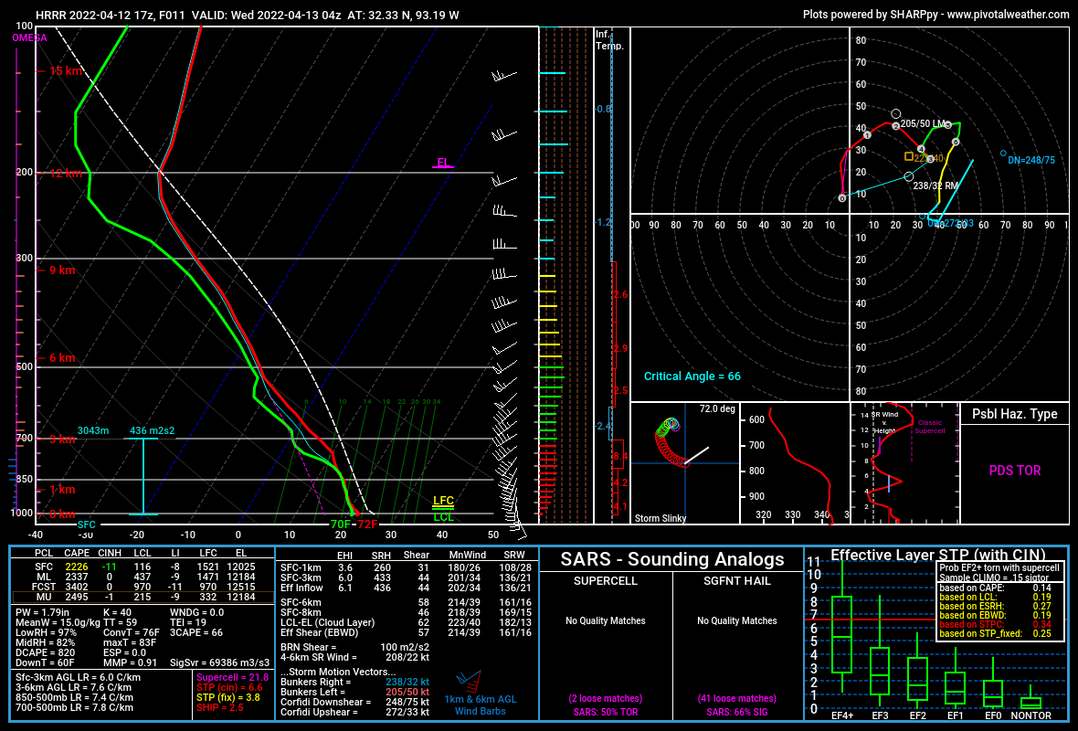
Posted on 4/12/22 at 2:03 pm to Duke
From up around Shreveport. The PDS was a little surprising.
Posted on 4/12/22 at 2:13 pm to Duke
Without pulling it up I’m gonna guess our upper air profile in Wichita resembles Norman pretty closely? Wind is nuts but it’s dry as hell outside.

Posted on 4/12/22 at 2:17 pm to Pedro
We have a moderate risk for tomorrow now, btw.

Tornado probabilities:

Severe wind probabilities:
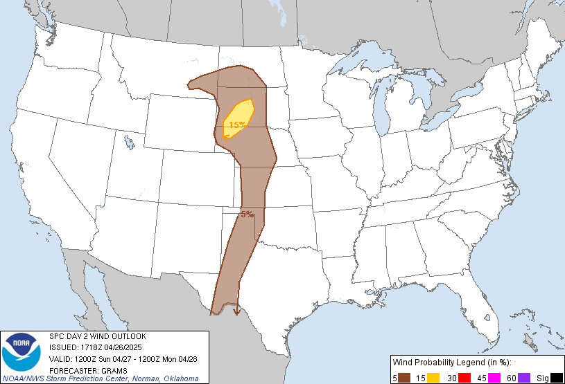
Tornado probabilities:
Severe wind probabilities:
Posted on 4/12/22 at 2:17 pm to Pedro
They didnt do one for some reason, but Id have to image you're like Norman but a bit drier.

Posted on 4/12/22 at 2:26 pm to Duke
DFW (Frisco) initially showed cells popping up around 4:00 - carpool time. Radar now shows line moving through around 6:00ish. Need to figure out if I’m good for 4:30 carpool or picking him up a little early to miss any hail or severe weather.
Looks like 6:00 is the sever time now?
Looks like 6:00 is the sever time now?
Posted on 4/12/22 at 2:32 pm to Roll Tide Ravens
Looks like y’all will get a “suns out we are gonna die” catfish farm pic tomorrow
Posted on 4/12/22 at 2:47 pm to deltaland
Cells firing in central TX.
Iowa chewing on a big nothingburger
Iowa chewing on a big nothingburger
Posted on 4/12/22 at 3:14 pm to deltaland
Some storms building up in SE Arkansas as well
Posted on 4/12/22 at 3:44 pm to deltaland
Already decent hail in those TX storms.
Posted on 4/12/22 at 3:45 pm to LegendInMyMind
Gravity waves all over east Nebraska western Iowa. If anything can get going and rooted lookout

Posted on 4/12/22 at 3:47 pm to LegendInMyMind
The wind is whipping in LC right now.
Posted on 4/12/22 at 3:49 pm to beebefootballfan
Noticed that on radar. Gonna be a fun time out there. Looks like we’re primed for 11/midnight to get some t storms.
Posted on 4/12/22 at 3:53 pm to Pedro
In an update on the home front, I bought a jumbo rain gauge at Lowe's last week. I didn't pay attention and it is jumbo in size and measurement. Basically, one inch equals two inches....the gauge measurements are double what they should be. That's neither here nor there, though, because after only the second rain this morning the damn thing now doesn't seem to hold water.

Posted on 4/12/22 at 3:53 pm to Pedro
No severe weather, but this cell passing through BR right now has produced the most rain for me by far out of all the threats we have had over the past few weeks.
Posted on 4/12/22 at 3:55 pm to LegendInMyMind
quote:
From up around Shreveport. The PDS was a little surprising.
Is this for tonight or Wednesday? And please explain like I’m a 1st grader, cause I can follow along somewhat with text and radar but those squiggly lines all look the same to me. I’m about 40 miles SE of Shreveport.

 Page 26 of 81

Popular
Back to top