- My Forums
- Tiger Rant
- LSU Recruiting
- SEC Rant
- Saints Talk
- Pelicans Talk
- More Sports Board
- Coaching Changes
- Fantasy Sports
- Golf Board
- Soccer Board
- O-T Lounge
- Tech Board
- Home/Garden Board
- Outdoor Board
- Health/Fitness Board
- Movie/TV Board
- Book Board
- Music Board
- Political Talk
- Money Talk
- Fark Board
- Gaming Board
- Travel Board
- Food/Drink Board
- Ticket Exchange
- TD Help Board
Customize My Forums- View All Forums
- Show Left Links
- Topic Sort Options
- Trending Topics
- Recent Topics
- Active Topics
Started By
Message
 0
0


Posted on 1/9/20 at 1:02 pm to McCaigBro69
quote:
Driving to Houston tomorrow at noon for a wedding. Should be eventful.
Better channel your inner Bill Paxton baw!
Posted on 1/9/20 at 1:26 pm to 50_Tiger
I guess I better get to channeling Bill as well since I will be driving from Houston to Cut Off tomorrow afternoon. I can't leave Houston until after 1 pm or so so I should be ahead of the main line of storms, but I assume I will run into a few cells ahead of the front. Oh well, gonna be a stressful trip it looks like.
I don't mind the rain but the strong winds I hate while driving. I mean I have no problem changing lanes on I-10 but I would like to choose when and where my truck changes lanes LOL.
I don't mind the rain but the strong winds I hate while driving. I mean I have no problem changing lanes on I-10 but I would like to choose when and where my truck changes lanes LOL.

Posted on 1/9/20 at 1:44 pm to biggsc
I'm scheduled to fly into MSY at 10:30am on Saturday. This should be interesting.

Posted on 1/9/20 at 1:47 pm to ElPresidenteGrande
If you could. I’d try to change my flight and fly in tonight or early tomorrow.
Safe travels my friend
Safe travels my friend
This post was edited on 1/9/20 at 1:54 pm
Posted on 1/9/20 at 2:02 pm to biggsc
I have to drive from BR to Mobile Saturday morning. 
Posted on 1/9/20 at 2:07 pm to rds dc
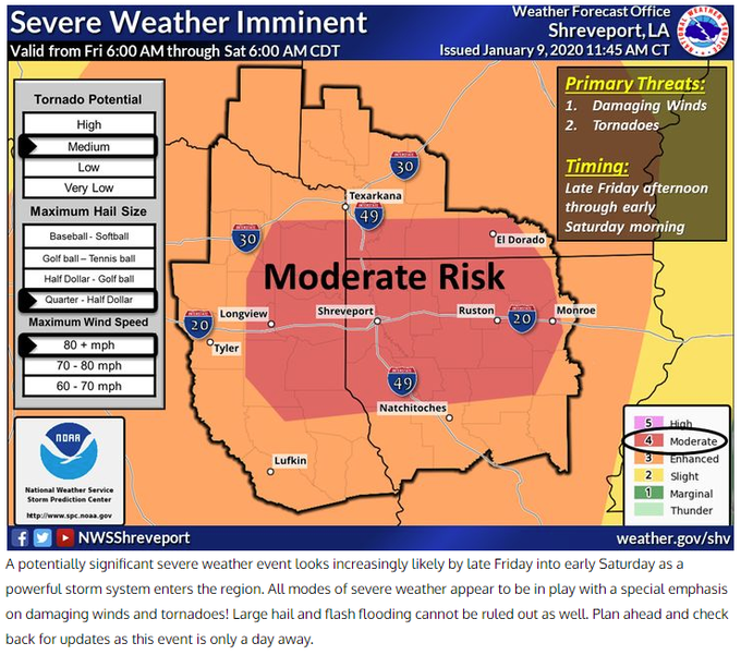
Update from Shreveport NWS, confidence is growing in a damaging wind event.

Posted on 1/9/20 at 2:10 pm to ell_13
I have to exist within the affected region during the projected window of concern.
Posted on 1/9/20 at 2:11 pm to rds dc
Shreveport looking like the bulleyes. Good luck

Posted on 1/9/20 at 2:12 pm to rds dc
well tomorrow is going to be fun
Posted on 1/9/20 at 2:16 pm to ell_13
quote:
I have to drive from BR to Mobile Saturday morning.
I'd leave really early in the morning
Posted on 1/9/20 at 2:18 pm to rds dc
URGENT - WEATHER MESSAGE
National Weather Service Birmingham AL
149 PM CST Thu Jan 9 2020
ALZ011>015-017>050-101115-
/O.NEW.KBMX.WI.Y.0001.200111T0600Z-200112T0300Z/
Marion-Lamar-Fayette-Winston-Walker-Blount-Etowah-Calhoun-
Cherokee-Cleburne-Pickens-Tuscaloosa-Jefferson-Shelby-St. Clair-
Talladega-Clay-Randolph-Sumter-Greene-Hale-Perry-Bibb-Chilton-
Coosa-Tallapoosa-Chambers-Marengo-Dallas-Autauga-Lowndes-Elmore-
Montgomery-Macon-Bullock-Lee-Russell-Pike-Barbour-
Including the cities of Hamilton, Sulligent, Vernon, Fayette,
Double Springs, Jasper, Oneonta, Gadsden, Anniston, Centre,
Heflin, Carrollton, Tuscaloosa, Birmingham, Hoover, Columbiana,
Pelham, Alabaster, Pell City, Moody, Talladega, Sylacauga,
Ashland, Roanoke, Livingston, Eutaw, Greensboro, Moundville,
Marion, Centreville, Clanton, Rockford, Alexander City,
Dadeville, Valley, Lanett, Lafayette, Demopolis, Linden, Selma,
Prattville, Fort Deposit, Hayneville, Wetumpka, Tallassee,
Montgomery, Tuskegee, Union Springs, Auburn, Opelika,
Phenix City, Troy, and Eufaula
149 PM CST Thu Jan 9 2020
...WIND ADVISORY IN EFFECT FROM MIDNIGHT FRIDAY NIGHT TO 9 PM CST
SATURDAY...
* WHAT...South to southeast winds 10 to 20 mph with gusts up to
40 mph expected.
* WHERE...all of Central Alabama.
* WHEN...From midnight Friday night to 9 PM CST Saturday.
* IMPACTS...Gusty winds could blow around unsecured objects and
blow down tree limbs. With saturated soils, weakened trees
could also be knocked down. A few power outages may result.
PRECAUTIONARY/PREPAREDNESS ACTIONS...
Use extra caution when driving, especially if operating a high
profile vehicle. Secure outdoor objects.
&&
$$
This post was edited on 1/9/20 at 2:23 pm
Posted on 1/9/20 at 2:21 pm to biggsc
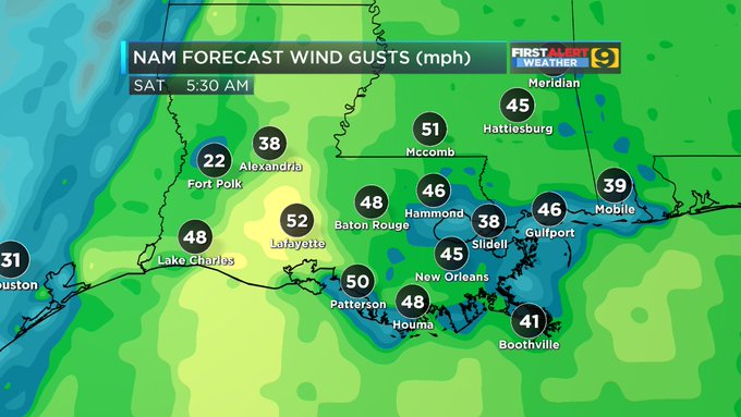
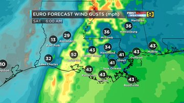
That's gonna be a problem also non thunderstorm wind gust on Saturday. Steve Caparotta put out a map saying Southeast Louisiana will see 40 to possibly 50 mph wind gust in non thunderstorms on Saturday.
Posted on 1/9/20 at 2:22 pm to lsuman25
Steve Caparotta, Ph.D.
@SteveWAFB
·
5h
Point of emphasis...severe weather or not, Saturday morning will be windy around the area. It's quite possible that we see some non-thunderstorm related power outages as winds gust over 40 mph, possibly over 50 mph in spots. #LAwx #MSwx
Posted on 1/9/20 at 2:24 pm to lsuman25
Especially from all these recent major rain events
Posted on 1/9/20 at 2:35 pm to rds dc
2 pm Thursday:
SLP at Austin , Tx. 1012.3 mb
SLP at Houston Bush: 1016.3 mb
SLP at MSY ( New Orleans ) 1023.5 mb
Difference of 11.2 mb over a distance of 450 miles.
SLP at Austin , Tx. 1012.3 mb
SLP at Houston Bush: 1016.3 mb
SLP at MSY ( New Orleans ) 1023.5 mb
Difference of 11.2 mb over a distance of 450 miles.
This post was edited on 1/9/20 at 2:41 pm

Posted on 1/9/20 at 2:59 pm to deltaland
quote:
2 shots for every use of the word “nothingburger”
Both center of mass, or are we putting one upstairs to make sure?
I'm not looking forward to the wind in SELA, but I'll take it over what it's looking like NWLA is gonna get.
This post was edited on 1/9/20 at 3:04 pm

Posted on 1/9/20 at 3:14 pm to Lsuhoohoo
Fulltilt Weather might be very legit but it would be helpful if they could write coherently.
Posted on 1/9/20 at 3:23 pm to Pettifogger

quote:
Probability of severe weather within 25 miles of a point.
Hatched Area: 10% or greater probability of significant severe weather within 25 miles of a point. (More Info)
Posted on 1/9/20 at 3:24 pm to slackster
What's that mean Slack? like high winds/tornado/hail as opposed to a standard severe t storm?

 Page 9 of 51

Popular
Back to top